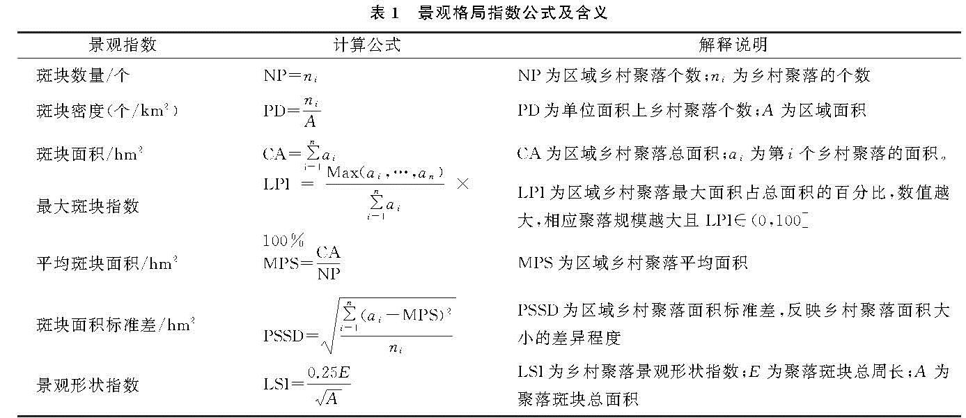
3.2.1 乡村聚落全局关联格局
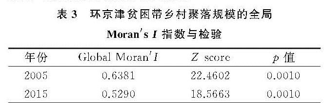
以环京津贫困带所辖乡镇作为空间分析单元,运用ArcGIS软件统计2005年、2015年各乡镇乡村聚落规模,借助Geoda软件的空间分析工具计算全局Moran's I指数,并对结果进行显著性检验。从表3中可以看出,2005年全局Moran's I为0.638 1年、2015年为0.529 0,且p值均小于0.01,均通过显著性检验。表明环京津贫困带全域范围内乡村聚落空间分布呈正相关,且存在显著的空间集聚态势,但这一集聚分布态势逐步减弱,乡村聚落空间分异性增强。
表3 环京津贫困带乡村聚落规模的全局Moran's I指数与检验
3.2.2 乡村聚落局部关联格局
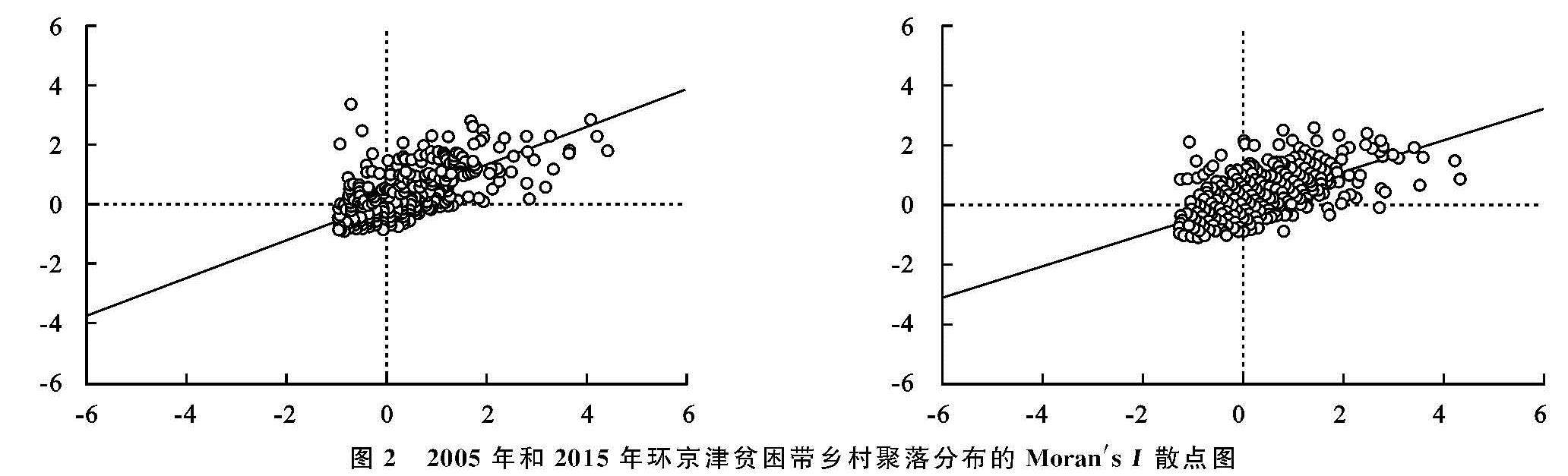
借助Geoda软件空间分析功能,采用邻接权重矩阵,生成环京津贫困带乡村聚落局部Moran's I散点图。横轴为2005年和2015年环京津贫困带乡村聚落的面积,纵轴表示相邻各县乡村聚落面积的滞后值。根据横纵坐标将Moran's I散点图划分为4个象限:第一象限(高—高型集聚)和第三象限(低—低型集聚),表示各县乡村聚落面积呈正相关关系; 第二象限(低—高型异常)和第四象限(高—低型异常)表示各县乡村聚落面积呈负相关关系(图2)。
由图2可以看出:(1)环京津贫困带乡村聚落分布大部分点落于第一象限和第三象限中,2005年和2015年点数总和分别为196个和156个,远多于落在第二象限和第四象限中的11个和13个。伴随旧村改造、新农村建设等政策推行,将原本零散分布或地处恶劣环境的乡村聚落实行迁并,新建乡村聚落有计划的集中布局,使得环京津贫困带乡村聚落分布呈现明显的空间集聚特征,并呈正相关关系。(2)环京津贫困带乡村聚落分布具有高值区和低值区集聚现象,且低值区占主导地位,占乡镇总数的21.33%。2015年同2005年相比,高值区和低值区乡镇数量均减少,落在第一象限乡镇数量由87个变为72,落在第三象限乡镇数量由109个变为84个。铁路、道路等城乡基础设施建设的不断完善,改变了乡村聚落空间扩展方向,可供乡村聚落规划选址区域增多,环京津贫困带乡村聚落异质性分布特征加强。(3)环京津贫困带乡村聚落分布整体呈现集聚态势,但局部异质性增强。散点图中趋势线反映了区域空间自相关水平一般趋势,2005年与2015年大部分数据点在趋势线两侧分布,尤其是落入第二象限的数据点2015年比2005年明显向趋势线集聚,远离趋势线分布的数据点主要出现在第四象限。
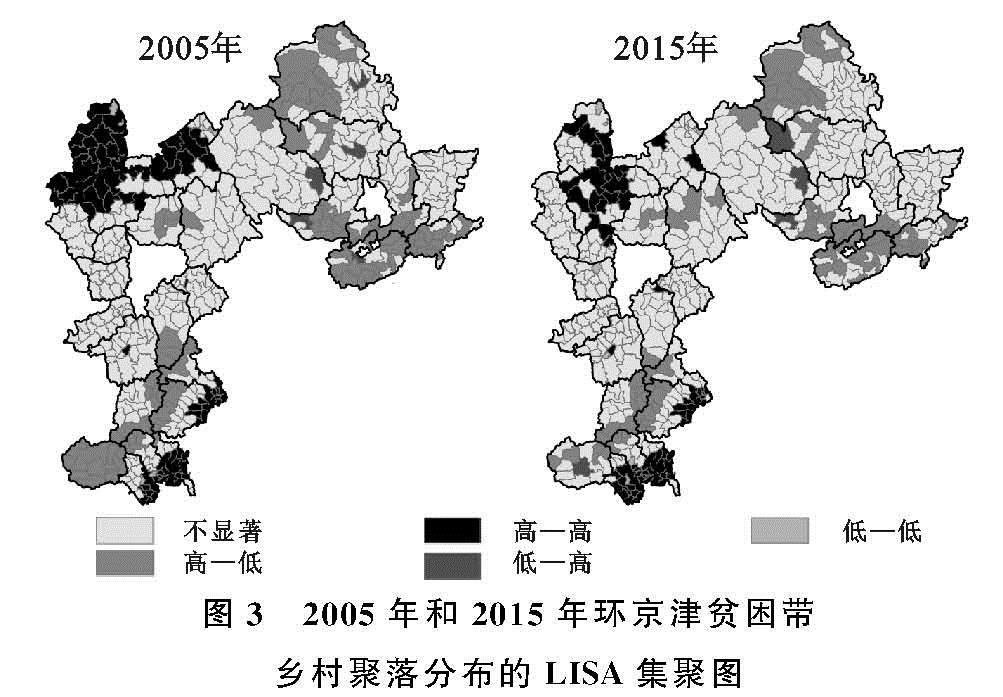
为了更加直观反映环京津贫困带乡村聚落的空间集聚特征,进一步探索乡村聚落的空间关联情况,本文在Z值检验的基础上,借助ArcGIS软件将Moran's I散点图绘制成LISA集聚图,见图3。
图2 2005年和2015年环京津贫困带乡村聚落分布的Moran's I散点图
图3 2005年和2015年环京津贫困带乡村聚落分布的LISA集聚图
(1)“高—高”类型区的乡镇数据点落于Moran's I散点图的第一象限内,存在显著的空间正相关。该类型区域主要分布在环京津贫困带东南部的涞水、易县、顺平、望都、唐县及曲阳县部分乡镇,以及西北部的沽源、尚义、张北及康保的部分乡镇,零散分布于逐鹿和蔚县的个别乡镇。该区内乡镇之间乡村聚落分布的局部差异小,2015年与2005年相比,乡村聚落高值区在空间分布上出现一定变化,西北部的高值区大幅度减少且呈现向南部蔓延趋势,东南部的高值区呈增加与减少并存趋势,其中曲阳县高值区增幅较为剧烈。
(2)“低—低”类型区的乡镇数据点落于Moran's I散点图的第三象限内,存在显著的空间正相关。该类型区主要分布在燕山—太行山脉附近及坝上高原区。由于区内海拔较高、地形起伏较大,极易发生自然灾害,如滑坡、崩塌、泥石流等。导致乡村聚落数量相对较少,且乡村聚落的规模也较小; 从时间变化来看,2005—2015年乡村聚落“低—低”类型区明显减少,主要是人们在居民点选址中更倾向于地形条件好、基础设施完善的区域。
(3)“高—低”类型区的乡镇数据点落于Moran's I散点图的第四象限内,存在显著的空间负相关。2015年同2005年相比,兴隆县平安堡镇、隆化县汤头沟镇以及围场朝阳湾镇从该类型区转为相关性不显著区,滦平县滦平镇与隆化县郭家沱镇则由“低—低”类型区转为该类型区,由空间正相关转为空间负相关。由于环京津贫困带乡村聚落相对密集的乡镇不断带动周边乡镇发展,致使乡村聚落规模增加,由“高—低”类型区转为不显著区。
(4)“低—高”类型区的乡镇数据点落于Moran's I散点图的第二象限内,存在显著的空间负相关。2015年同2005年相比,唐县雹水村转为“高—高”区域,唐县迷城乡、蔚县蔚州镇、万全县第六屯乡、怀来县鸡鸣驿乡转为该类型区。该类型区乡村聚落分布规模差异较大,异质特征明显,在乡村聚落规模小的区域,其周围乡镇的乡村聚落规模大,从而形成局部异质的“冷点区”。
3.3 环京津贫困带乡村聚落空间分布的影响因素
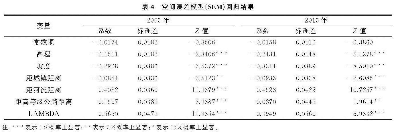
乡村聚落作为一个复杂系统,其空间分布和格局演变受到多种因素的影响,各种因素之间相互作用、相互影响,共同驱动乡村聚落空间系统的演变和发展。本文引入空间计量模型,从空间维度探讨影响乡村聚落时空分异要素之间的关联性。参考已有研究[22-23],本文选取各乡镇乡村聚落规模面积的均值(KD)作为被解释变量,以乡村聚落所在高程(DEM)均值、坡度(SLO)均值和乡村聚落距离各城镇(URB)、河流(RIV)及高等级公路(ROA)最近距离的均值作为解释变量,并标准化处理所有变量。基于Geoda软件平台的空间依赖性检验,根据Anselin提出的模型判别准则选取模型,结果显示空间误差模型(SEM)优于空间滞后模型(SLM),更适合判断环京津贫困带乡村聚落分布与影响因素的空间相关性。基于空间回归模型相关理论,探讨影响环京津贫困带乡村聚落空间分布的影响机理,见表4。
(1)选取的影响因素对乡村聚落空间分布均有明显作用,两个年份的检验系数均通过5%的显著性。高程、坡度与距城镇距离表现出负相关,其他影响因素均为正相关。其中,高程的高低与坡度的大小决定了该地区土地开发利用难易程度,是居民点选址的首要考虑因素,直接关系到乡村聚落的空间分布与集聚特征,因此,高程越高、坡度越大的地区,乡村聚落分布较少。河流流经区域水土条件相对较好,有利于农业生产和居住生活,是乡村聚落选址所要考虑的重要因素之一; 交通路网是聚落之间进行物质、能量和信息流动的重要载体,临近高等级公路的村落通勤和生活成本都较低,使得乡村聚落倾向于在河流两侧与高等级公路周边集聚。近年来,随着城镇化进程不断推进,城镇除了通过辐射作用影响乡村聚落分布以外,其扩张也会吸引附近乡村聚落用地向城镇工矿用地转变,距离城镇中心越近,转为城镇工矿用地的可能性越大; 同时,由于环京津贫困带整体城镇化程度较低,城镇建成区面积用地规模小,大部分乡村聚落距离城镇较远,城镇对其周边乡村聚落辐射能力较弱,不能在城镇周边形成集聚和吸引; 因此,距城镇距离变量与乡村聚落分布表现出负相关,从侧面体现出贫困地区城镇化发展对乡村聚落布局影响的复杂性。
(2)2005年与2015年各解释变量的系数绝对值大小均为:距河流距离>坡度>高程>距高等级公路距离>距城镇距离。相关系数绝对值大小反映该因素对环京津贫困带乡村聚落空间分布的影响程度,由绝对值大小可知距河流距离与坡度是影响乡村聚落空间分布的主要因素。分析2015年同2005年系数变化值,距河流距离、坡度、高程与距城镇距离的回归系数分别增加0.044 1,0.040 3,0.082,0.009 1,距高等级公路距离的回归系数减少0.063 7; 也体现出高程与距河流距离是引起乡村聚落空间分布变化关键因素,一方面,环京津贫困带内6个县位于坝上高寒地区,其余均位于太行山及燕山深山区,为方便农业生产和农民生活,自然本底的高程因素成为乡村聚落选址时着重考虑的因素; 此外,环京津贫困带干旱缺水、河网体系不发达,距河流距离对乡村聚落集聚和空间分布起到了显著的主导作用; 另一方面,由于该贫困带高等级公路网络不健全、道路等基础设施不完善,导致距高等级公路距离对于乡村聚落空间布局的影响呈减小趋势。