4.1 生态需水测评模型
4.1.1 植被生态需水测评模型
影响植被蒸散水平的主要因素包括气候条件、土壤和植被生长状况等。研究选用的植被生态需水量测评模型为:
Wp=Ep×Ap=(ET0×Kc×Ks)×Ap(1)
式中:Wp为植被生态需水(m3); Ep为植被蒸散量(mm); Ap为植被分布面积(m2); ET0为参考作物潜在蒸散量(mm); Kc为植被系数; Ks为土壤水分限制常数。研究采用植被在生长期各月蒸散量的最小值来计算植被最小生态需水。
4.1.2 土壤生态需水测评模型
对于不同的区域,如果植被不是完全覆盖,那么只有植被生长下的土地的土壤含水量,才是真正意义上的土壤需水量。故利用GIS叠加分析工具对植被类型分布图和土壤质地分布图进行处理,得到植被—土壤类型分布图。研究选用的土壤生态需水测评模型为:
Ws=as×Hs×As(2)
式中:Ws为土层深度Hs下的土壤需水(m3); as为植被区土壤含水定额(m3/m3); Hs为土层深度(m); As为植被区面积(m2)。植被的生长阻滞含水量是指能够维持植物生存和基本生长所需要的土壤最小含水量。参考相关土壤文献[16-18],根据杨志峰等[19-20]对黄河流域植被生态需水的研究,以土壤含水量占土壤田间持水量的55%来确定土壤的最小需水等级,由于渭河流域为黄河流域的二级子流域,同时结合课题组野外采集土壤样本经烘干法测得不同土壤质地含水量,计算结果和文献资料里的土壤田间含水量接近,所以研究取田间持水量的55%作为土壤的最小含水定额来计算土壤最小生态需水[21-22]。
4.1.3 植被—土壤复合系统生态需水量测评结果与分析
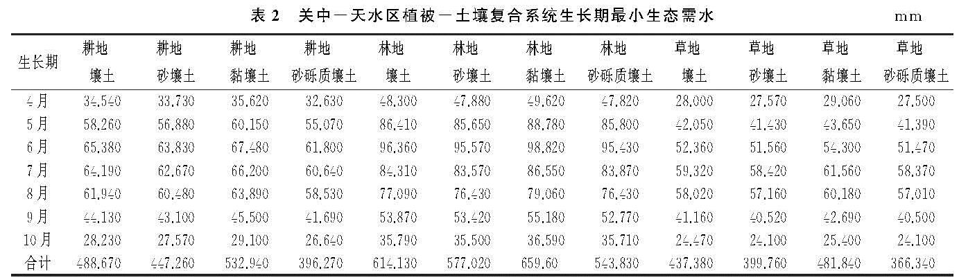
根据选用的生态需水测评模型,计算得到关中—天水区植被—土壤复合系统在生长期多年平均单位面积最小生态需水量(表2)。
表2 关中-天水区植被-土壤复合系统生长期最小生态需水mm
结合表2分析可知,植被—土壤复合系统的最小生态需水是先增加后减少的趋势,生态需水较高的时期主要出现在每年的6—8月,这和作物的发育生长阶段相一致。研究区北部北山及南部秦岭地区是高度生态需水的主要集中区域,低度生态需水的区域相间分布于区域河流两侧,其中天水中、北部地区较为集中。高度生态需水的地区主要为与林地组合的各类景观类型,其中林地—黏壤土的生态需水量最大,约为659.60 mm,比最低的景观类型单位面积最小生态需水多293.26 mm。中度生态需水的景观类型主要为草地—壤土、草地—黏壤土、耕地—砂壤土、耕地—壤土、耕地—黏壤土,其单位面积生态需水介于437.38~532.94 mm。草地—砂壤土、耕地—砂砾质壤土、草地—砂砾质壤土的单位面积最小生态需水均低于400 mm,其中草地—砂砾质壤土最低,约为366.34 mm。
4.2 基于CA-Markov模型的土地覆被空间分布预测结果与分析
元胞自动机(CA,Cellular Automata)是一种能实现巨复杂系统时空演变过程模拟的数学模型[23],马尔可夫模型(Markov Model)通过利用系统已有离散状态的经验传递概率来实现其未来发展状况的模拟预测[24-25]。将CA和Markov组合为CA-Markov模型,可以实现对土地利用的数量结构及空间分布进行准确预测[26]。
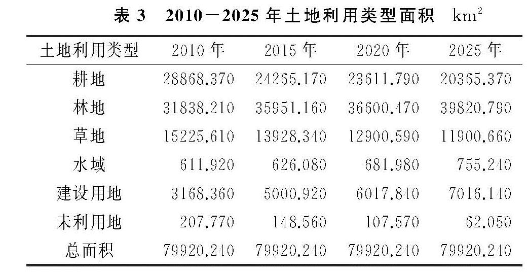
研究基于IDRISI 17.0软件中的CA-Markov模型,以2010年、2015年数据为基础计算其概率矩阵,迭代系数取10,过滤器为5×5,完成研究区2020年和2025年土地利用空间分布的预测(图2),各年份土地利用类型面积见表3,并利用ArcGIS的分区统计功能,统计得到不同景观类型和不同生态功能区的生态需水(表4)。
2010—2025年期间,关中—天水经济区土地利用面积减少的有耕地、草地、未利用地,土地利用面积逐年增加的有林地、建设用地、水域,变化幅度较大的为耕地、林地、草地和建设用地[26]。其中耕地面积减少了8 503 km2,这与国家退耕还林政策的实施和城市化的发展有关[27]。林地面积增加了7 982.58 km2,主要原因在于各重要森林保护区和渭河整治绿化工程的建设。建设用地面积增加了3 847.78 km2,主要分布于河流两岸和西安等大中城市周边。水域面积略有增加,这与各调水工程和人工水库的修建有关。草地面积减少了3 324.95 km2,增加的耕地、林地和建设用地主要来源于草地的转换。未利用地面积逐渐减少,表明区域土地利用开发效率不断增强。
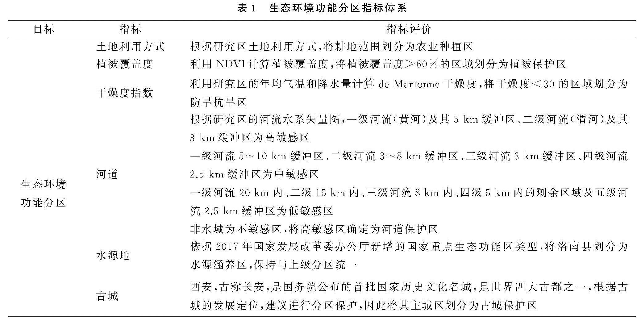
图2 2015-2025年关中-天水区土地利用空间分布模拟结果与生态功能类型分布
根据图2分析可知,生态功能区的分布与土地利用方式密切相关。植被保护区和水源涵养区分布的地区主要为林地,农业种植区分布的地区主要为耕地,河道保护区分布的地区主要为水域,古城保护区分布的地区主要为建设用地,防旱抗旱区在耕地、林地、草地等都有分布。这表明生态功能区的生态需水与土地利用方式存在相关性。
4.3 基于生态环境功能分区尺度的生态需水量测评结果与分析
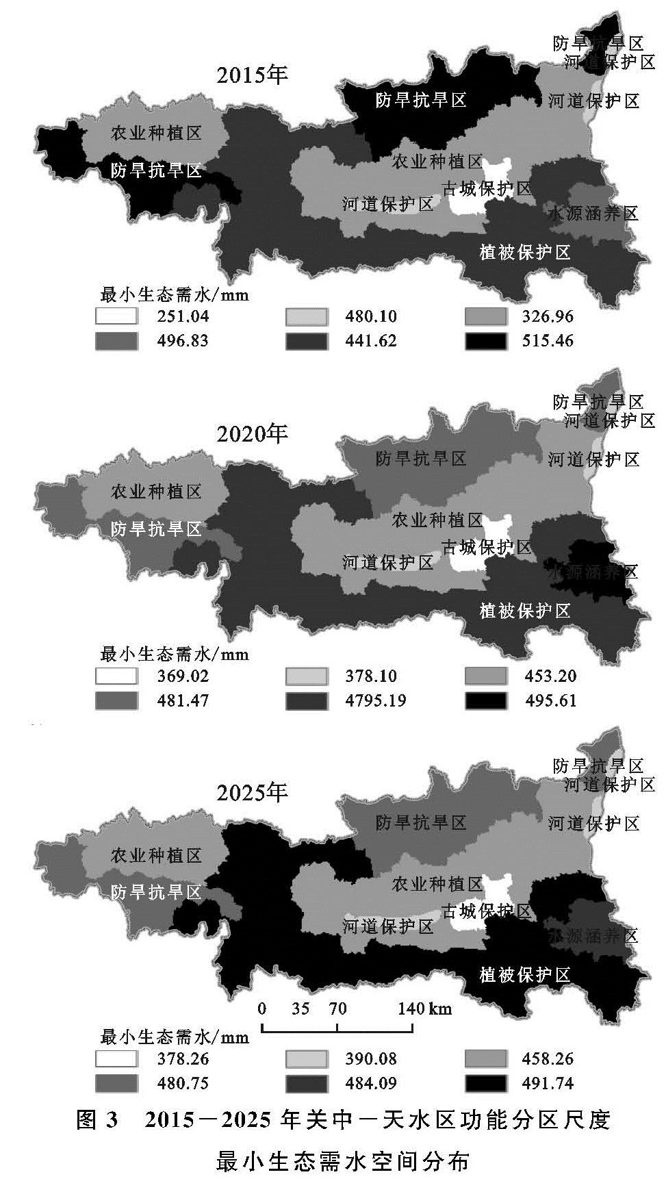
基于测算的植被—土壤系统多年平均生态需水量,利用ArcGIS的分区统计功能,以CA-Markov模型模拟预测的2020年、2025年土地利用空间分布作为输入图层,以植被—土壤系统平均生态需水量栅格数据作为赋值图层,统计得到2020年、2025年土地利用空间分布变化后的生态需水量,再以该图层作为赋值栅格,以生态环境功能区作为输入图层,统计得到不同生态功能区的生态需水量(图3)。
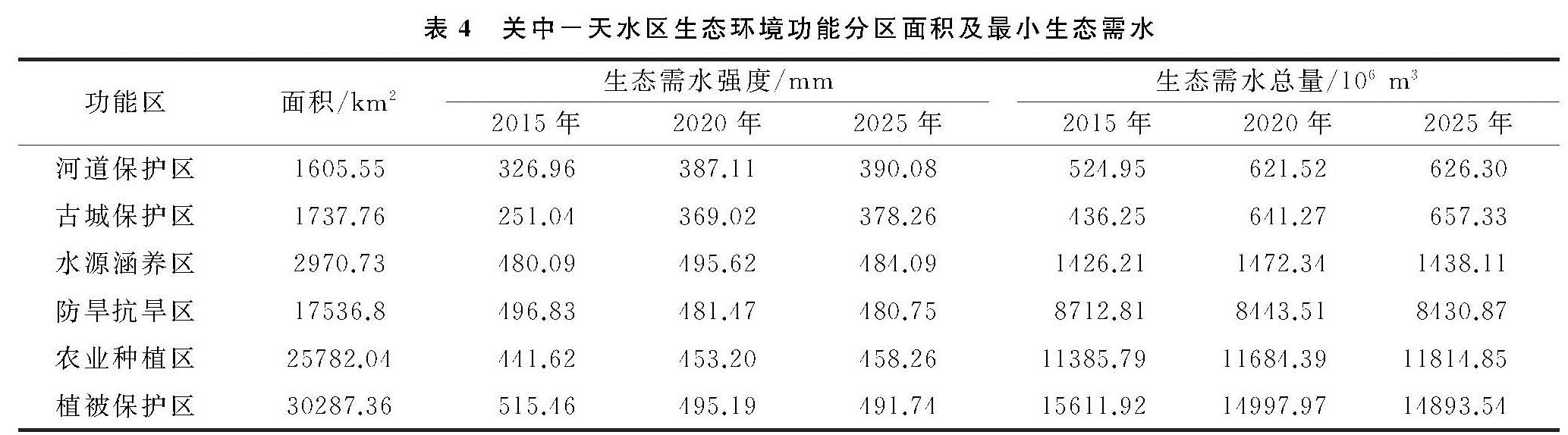
表4 关中-天水区生态环境功能分区面积及最小生态需水
由表4可知,不同年份生态功能区的生态需水略有差异,从单位面积生态需水量来看,测评的3个年份中,古城保护区的单位面积生态需水量是最小的,原因在于古城保护区主要分布于西安城区,土地利用类型主要为建设用地,本研究未测评建设用地和水域的生态需水,其生态需水是留空白的,因此生态需水量小; 植被保护区的单位面积生态需水量最大,原因在于林地的单位面积生态需水量是各种土地利用方式当中最大的,而植被保护区主要分布的植被类型为林地,因此生态需水量大; 值得注意的是2020年单位面积生态需水量最大的为水源涵养区。由图2可知,2020年水源涵养区相比2015年、2025年其林地覆盖面更广,而对应的2020年植被保护区内有更多的林地转换为了其他用地类型,因此,植被保护区单位面积生态需水量变小了,但比水源涵养区的单位面积生态需水仅小了0.43 mm。
从生态需水总量来看,测评的3个年份中,生态需水总量从小到大依次为:河道保护区、古城保护区、水源涵养区、防旱抗旱区、农业种植区、植被保护区,这与各功能区的面积顺序保持一致。结合图2分析可知,河道保护区和古城保护区主要分布的土地利用类型为水域和建设用地,因此生态需水量小; 而植被保护区主要分布的土地利用类型林地,且又是各功能区中面积最大的,因此其生态需水总量最大。
图3 2015-2025年关中-天水区功能分区尺度最小生态需水空间分布