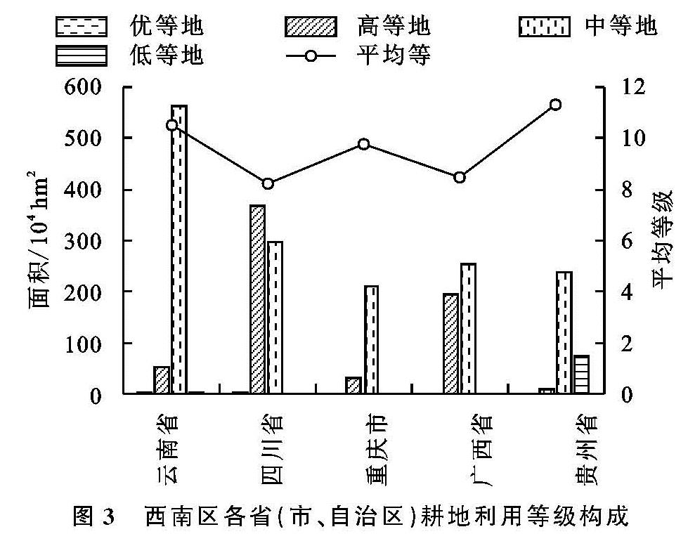
西南5省(市、自治区)因四川省2015年耕地质量等别年度更新中尚未明确提供各市耕地等别分布情况,因此未将四川省地类数据统计在内,剔除其耕地质量空间分析,本文以其余4省(市、自治区)共有77个市(区、县)为研究单元进行空间自相关分析。
3.4.2 局部自相关分析
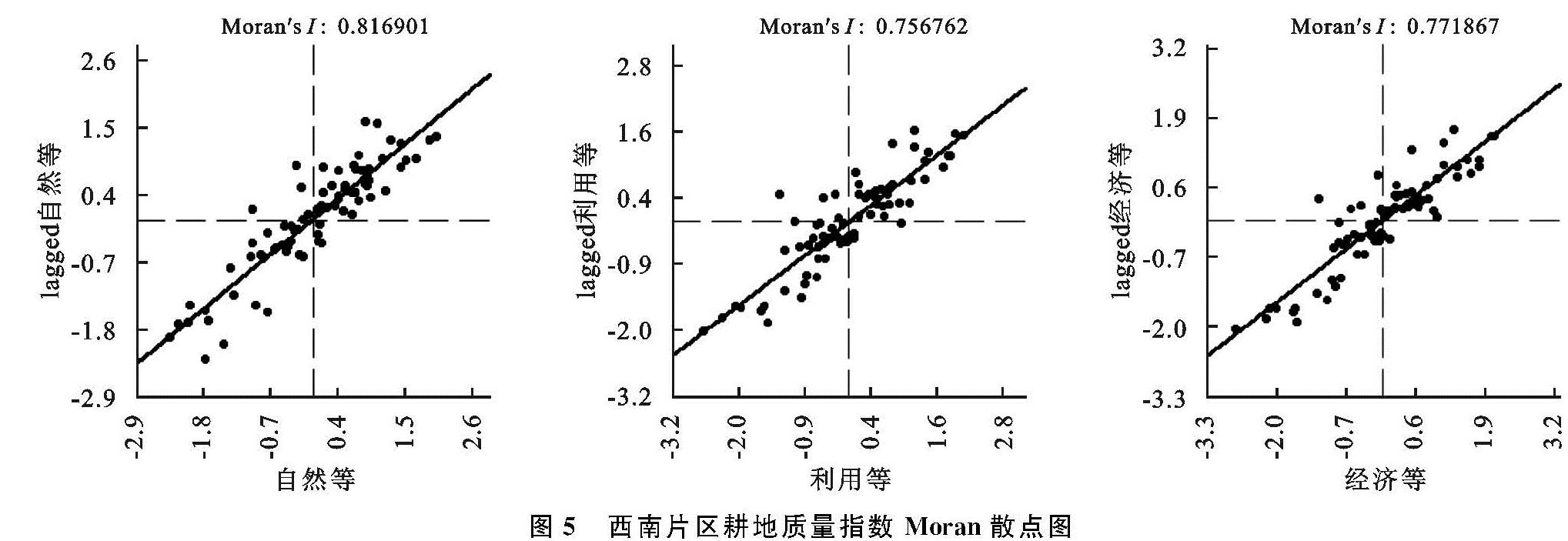
利用局部空间自相关指数将耕地质量空间分布划分为5 种类型:HH 型(高—高)、LL型(低—低)、HL型(高—低)、LH(低—高)型和NS(非显著)型(农用地分类中,国家等的等别数值越低代表耕地质量最高,反之代表质量越低)。西南片区4省(市、自治区)耕地质量自然等、利用等和经济等指数LISA图如附图12所示。
自然等指数HH地区呈现片状聚集于云南省北部的横断山区、云贵高原区中部及贵州省西部地区,包括迪庆州、黔西南及贵阳市等14个州(市); LL地区也呈现片状分布于广西自治区东南部自然条件较好的江南区和华南区,包括桂林市、玉林市和北海市等11个市,其中LL还包括了重庆市的璧山区; LH和HL区域内无分布。利用等指数HH地区呈团状聚集,区别于自然等的连片聚集,HH型聚集于云南省西北部横断山区和贵州省大部,包括迪庆州、怒江州、六盘水市和毕节市等13个州(市); LL地区呈现片状分布于广西自治区大部,较自然等聚集更多,除河池市和百色市外,其余12个市均为LL型; LH和HL区域内无分布。经济等指数HH云南省地区有所减少,贵州省除遵义市外,都为HH型,云南省昭通市、曲靖市及西北部的怒江州和迪庆州等地,共13个州(市)为HH; LL地区依旧呈现片状分布于广西自治区大部的11个市; 大理州是唯一的一个LH型地区,经济等无HL型。
3.5 讨 论
(1)将自然条件与西南片区自然质量等别进行叠加分析。市际分布和聚类分析均显示云南省西北部的怒江州、丽江市等地与贵州省西部的威宁县和毕节市等地由于地处横断山区和云贵高原区,受到地形地貌的影响,区域内整体地势高低起伏,光热条件较差,水资源匮乏,土壤贫瘠,且多以坡耕地和旱地为主,容易引发水土流失等自然灾害,生态环境极其脆弱,耕地质量整体较差与HH型在空间分布上相匹配; 而位于东南部的广西自治区各市(州),地处华南区和江南区,占据优越的自然条件,受到海洋暖气流的影响,降雨量充足,光热条件较好,土壤含水量较高,在一定程度上决定了耕地质量,与自相关LL型空间分布相匹配; 此外,重庆市西北部的璧山区、江津区和永川区等地与云南省西南部的西双版纳州和德宏州地处四川盆地区和华南区,地势平坦,虽不及沿海地区的农业自然条件,但光温生产潜力及降雨充沛部分弥补了影响,耕地质量呈现中上水平; 其余各区域内耕地数量分布较多但质量较为一般,多以中等地分布为主。
(2)将耕地自然质量、生产投入等条件与西南片区利用等别进行叠加综合分析。结果显示质量较好的耕地集中分布于广西自治区大部和云南省德宏州和西双版纳州等地,因地处华南区和江南区热量灌溉水源充足,农业条件较好,精细耕种历史悠久,耕作方式多样,生产投入和粮食作物产量明显高于其余地区,利用等别都相对较高,与自相关LL型在空间分布相匹配; 利用等别较低的耕地主要分布于横断山区的怒江州、迪庆州等地和云贵高原区的贵州省大部和昭通市等地,区域内耕地多分布于峡谷地带,不利于机械化耕作,少数名族聚集,耕地分布零散且多以旱地和坡耕地为主,农业条件较差,水资源相对匮乏,得不到相应的投入—产出效益,与HH型在空间分布上相匹配; 此外,重庆市西部涪陵区和璧山区等地与云南省大理州、玉溪市等地利用等呈现中上水平,地处四川盆地区具有良好的自然条件,也为农业发展提供了基础,而大理州、玉溪市境内的洱海流域及抚仙湖流域灌溉水源充足,土壤肥沃,机械化耕作便利,为当地农业发展提供了良好的基础; 其余重庆市南部山区各区(县)和云南省大部耕地质量一般,区域内耕地多分布于地形相对平缓和自然条件较好的坝区,耕地数量分布较多,等别差异明显,但受限于自然条件、水热搭配的影响,利用等整体中等偏下。
(3)经济等反映了耕地的综合质量的优劣,将自然条件、生产投入、区域经济发展状况和基础设施建设等各方面因素与西南片区经济等别进行叠加分析。经济等较低的区域与自然等及利用等相似,聚集于横断山区的怒江、迪庆等地与云贵高原区的毕节市和威宁县等地,区域内地形地貌已严重影响耕地的综合投入—产出效益,农业生产交通不便,此外由于城镇化的推进,占用了地势较为平缓区域的耕地,经济等质量整体较差,与自相关HH型在空间分布上相匹配; 而位于华南区的德宏州以及广西省大部,由于优越的自然条件,地势平坦,生产交通和机械化耕作便利,农业发展可观,刺激农业发展的因素较多,建设投入也相对较高,耕地综合质量都较高,与LL型空间分布相匹配; 重庆市西部及西北部各区(县)和云南省大理、玉溪和昆明等地经济等呈现中上水平,除地处四川盆地区或境内的高原湖泊影响外,这些区域都为社会经济发展发达,交通便利的平坝区; 经济等一般的耕地主要聚集在云南省大部和重庆市北部和南部山区,区域内耕地分布较广且零散,交通不便,依据各地经济发展状况,综合质量中等偏下。
综合来看,西南片区耕地质量整体呈现出由北往南耕地质量逐渐上升的空间分布规律,西南片区的自然环境、社会经济条件复杂多样与各地农业生产条件和方式、农业生产力水平差异,是耕地质量呈现区域差异的自然基础。生产投入和区域经济发展等在空间地域上分布有部分影响,但耕地等别的聚集很大程度上受到自然条件限制。通过以上分析,3类指数整体呈现出位于西北横断山区的怒江州、迪庆州等地和位处云贵高原区的贵州省大部由于自然条件和农业生产等条件的限制,直接影响耕地的综合投入—产出效益,区域内低等地高度聚集,此外地形坡度和气候等因素影响,土地整治及生态建设等措施也难以大幅度提高该地区各市的耕地质量,与HH型在空间分布上相匹配。而位于江南区和华南区的广西大部,有充足的灌溉水源,土壤肥沃,热量充足等优越的自然条件,刺激农业发展因素也较多,从而在一定程度上对耕地质量具有较大的影响,其表现特征也与LL型空间分布相匹配。