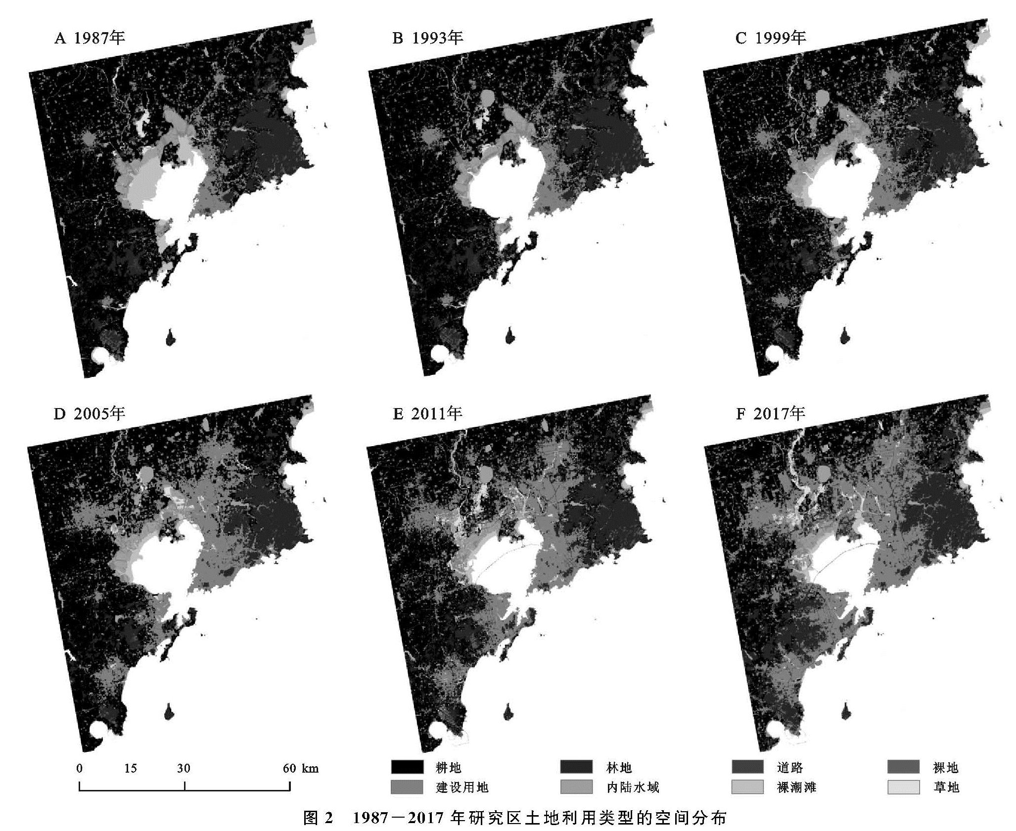
3.1 近30 a胶州湾周边土地利用变化
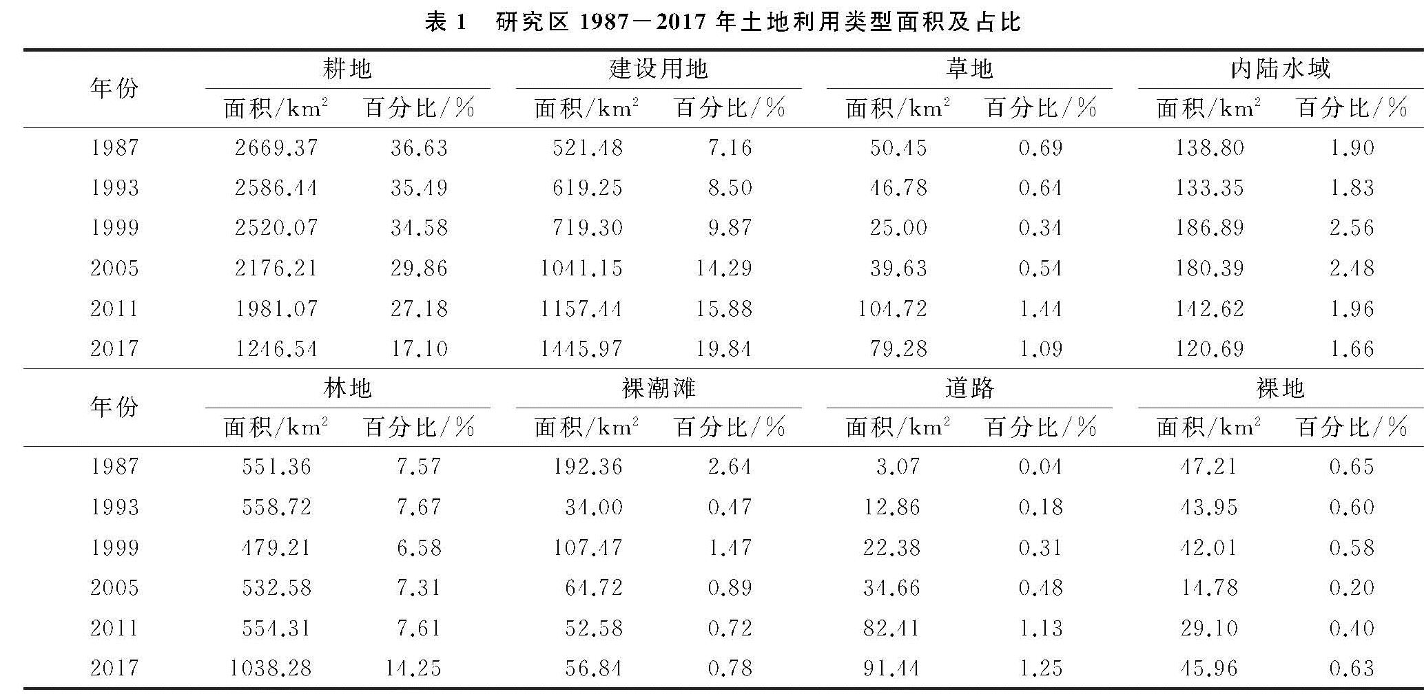
胶州湾及其周边地区近30 a来的土地利用变化情况见表1,土地利用类型的空间分布见图2,主要表现为:耕地面积不断减少,由1987年的36.63%减少到2017年的17.10%,面积总共减少了1 422.63 km2; 建设用地面积不断增加,由1987年的7.16%增加到2017年的19.84%,面积总共增加了924.49 km2; 道路面积不断增加,由1987年的0.04%增加到2017年的1.25%,面积总共增加了88.37 km2; 草地以及内陆水域的面积呈现“减少—增加—减少”的变化趋势; 林地面积呈现出“增加—减少—增加”的趋势; 裸地面积则呈现出“减少—增加”的趋势。由于裸潮滩为卫星成像时刻的潮滩,并非实际潮滩湿地,因此在此处不予讨论,将在下文进行讨论分析。
表1 研究区1987-2017年土地利用类型面积及占比
3.2 近30 a胶州湾潮滩湿地时空特征分析
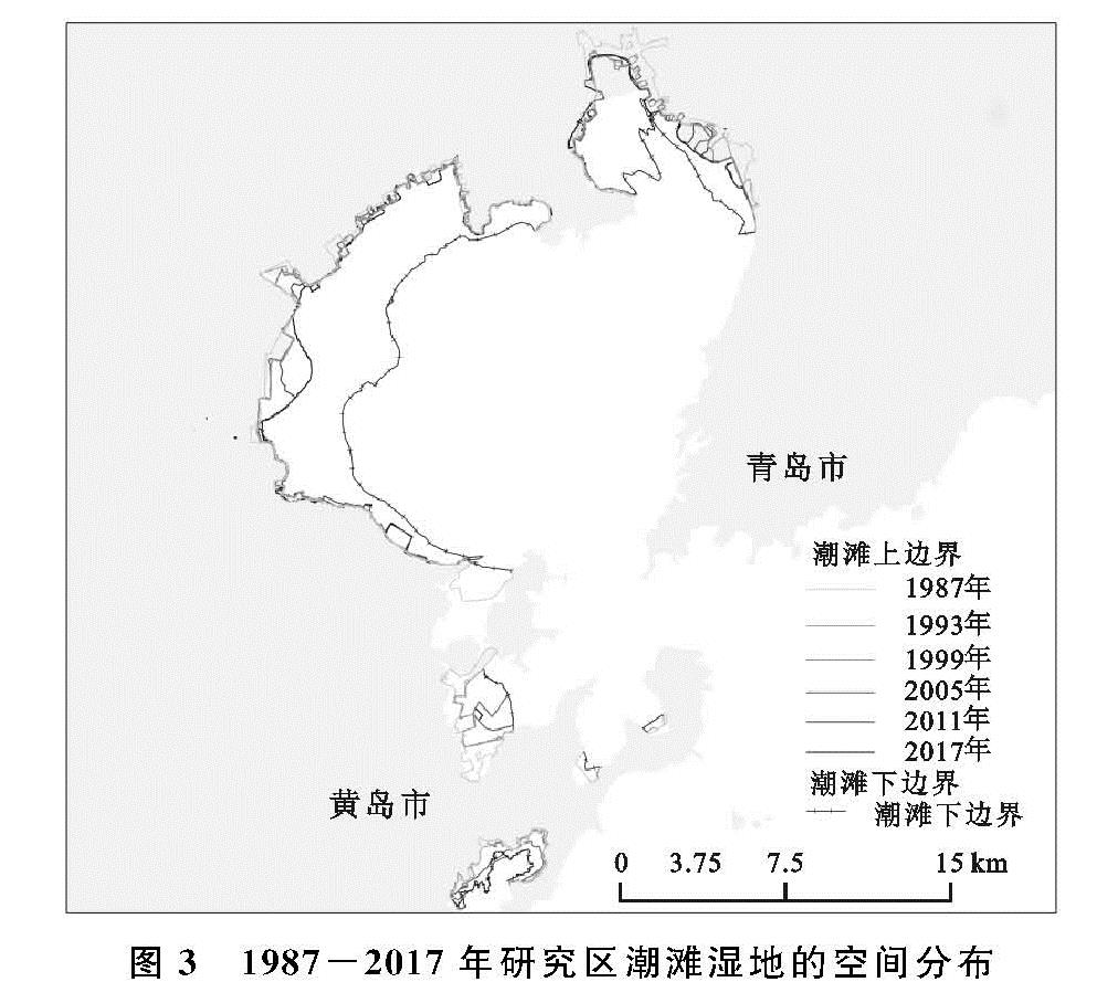
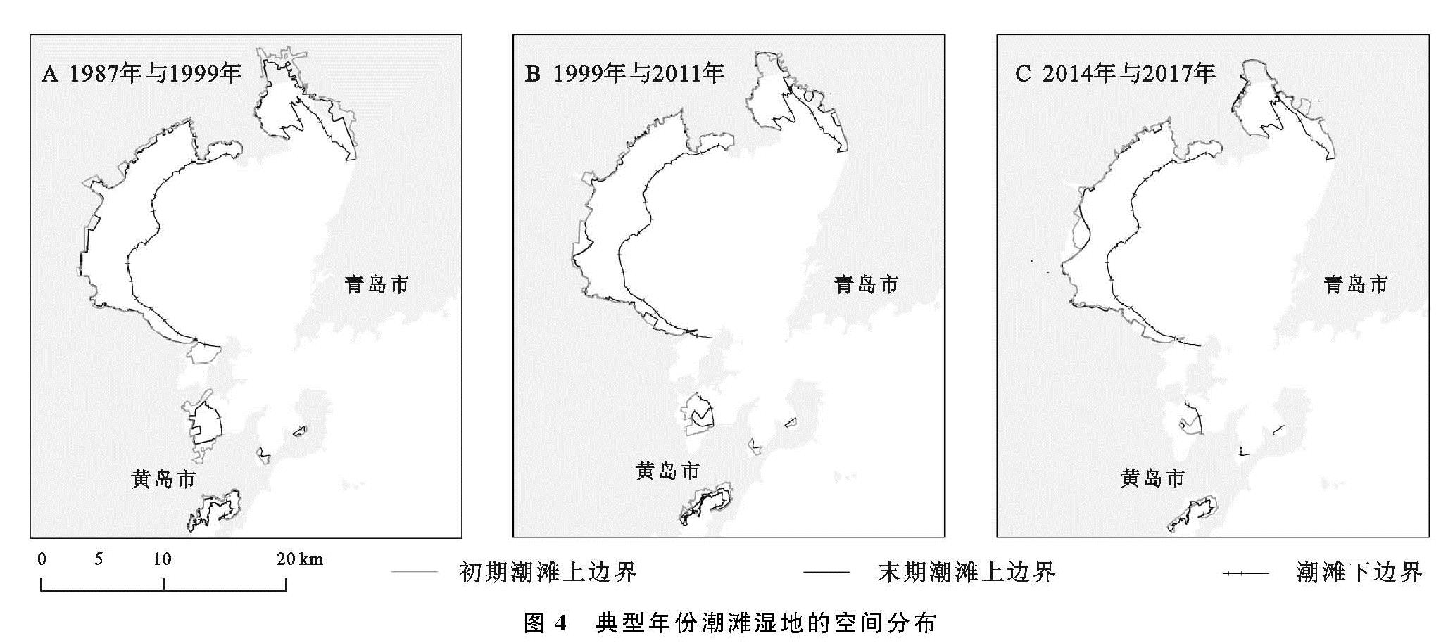
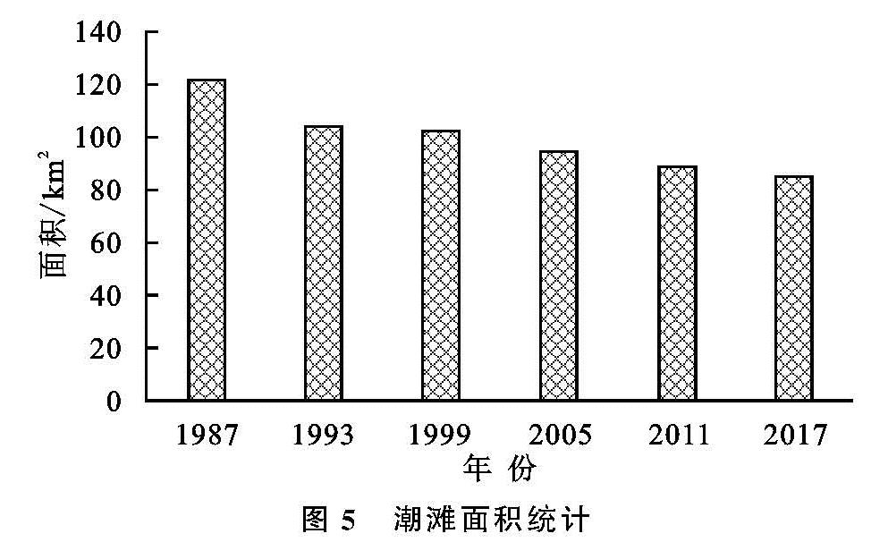
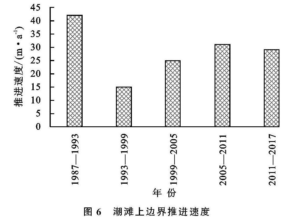
对潮滩湿地下边界校正完毕后,利用ArcGIS软件制作潮滩湿地的空间分布图(图3—4)、统计近30 a潮滩湿地的面积(图5)以及潮滩湿地上边界的平均推进速度(图6)。
图2 1987-2017年研究区土地利用类型的空间分布
1987年胶州湾的潮滩湿地面积最多,高达122.27 km2,该年的潮滩湿地分布广泛,集中分布于胶州湾的西岸、北岸以及唐岛湾沿岸; 1993年与1999年的潮滩湿地面积分别为104.03,102.73 km2,这两年的潮滩湿地空间分布范围大致相同,集中分布于胶州湾的北岸以及唐岛湾沿岸,有少量的潮滩湿地分布于胶州湾西岸; 2005年与2011年的潮滩湿地面积分别为94.73,89.09 km2,主要集中分布于胶州湾北岸以及唐岛湾沿岸,而胶州湾西岸的分布范围变小; 2017年潮滩湿地面积最少,为85.31 km2,主要集中分布在胶州湾北岸以及唐岛湾沿岸。
潮滩湿地上边界在1987—2017年30 a间向胶州湾内部推进,且近30 a的平均推进速度呈现出“减慢—加快—减慢”的趋势,1987—1993年的平均推进速度最快,约为42 m/a,而该时间段的青岛墨水河入海口处以及前湾港处的推进速度最快,为120 m/a; 1993—1999年的平均推进速度约为15 m/a; 1999—2005年的平均推进速度约为25 m/a,该时间段的唐岛湾沿岸的推进速度最快,最快推进速度约为135 m/a; 2011—2017年的平均推进速度与2005—2011年相比有所减慢,平均推进速度分别为31,29 m/a。
图3 1987-2017年研究区潮滩湿地的空间分布
总之,胶州湾近30 a来的潮滩湿地面积不断减少; 潮滩湿地上边界随着时间的推移不断地向胶州湾内部推进,年平均推进速度则呈现出“减慢—加快—减慢”的趋势。
3.3 潮滩湿地变化原因分析
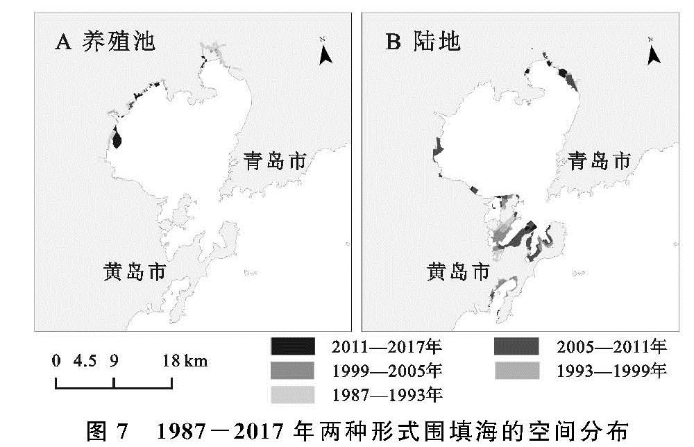
根据胶州湾近30 a的土地利用类型以及潮滩湿地分布的矢量数据,通过ArcGIS软件对而二者进行叠加分析得到近30 a胶州湾地区潮滩湿地变化的主要原因。
如图7所示,围填海活动是胶州湾近30 a潮滩湿地变化的主要原因,胶州湾近30 a围填海面积呈现“减少—增加—减少”的趋势。1987—1999年的围填海面积逐年减少,由1987—1993年的围填海面积16.36 km2减少到1993—1999年的最小面积4.30 km2; 1999—2011年的围填海面积则逐年增加,在2005—2011年,面积达到最大,为19.32 km2; 2011—2017年,围填海面积则呈现减少趋势。
图7 1987-2017年两种形式围填海的空间分布
通过结合近30 a的胶州湾周边的土地利用类型,进一步将围填海活动分为:潮滩湿地向养殖池转变、潮滩湿地向陆地转变。养殖池面积在1987—2011年逐年减少,其中1987—1993年的养殖池面积最大,高达11.59 km
2,而在2005—2011年养殖池的面积最小,为0.66 km
2,在2011—2017年面积有所增加,由0.66 km
2增加到4.70 km
2; 填海造陆面积在1987—2011年则逐年增加,在2005—2011年,造陆面积达到最大,高达18.66 km
2,在2011—2017年则有所减少,由18.66 km
2减少到4.26 km
2。
就两种围填海活动的空间分布而言,潮滩湿地向养殖池的转变在1987—2017年30 a间,集中分布于胶州湾北岸,少量分布在胶州湾西岸以及唐岛湾沿岸; 潮滩湿地向陆地的转变在近30 a间则集中分布于胶州湾东北岸、西岸的黄岛区以及唐岛湾沿岸。
3.4 围填海土地利用结构分析
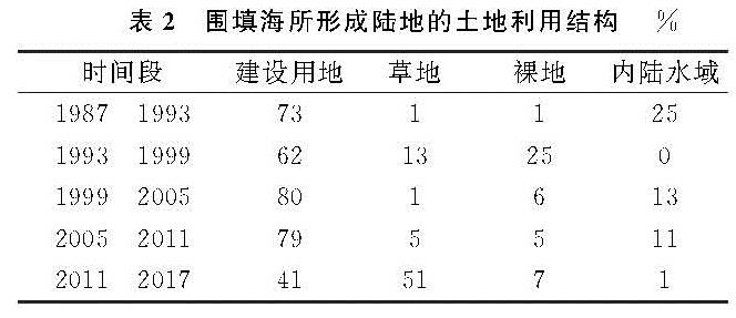
从表2可以看出,围填海所形成的陆地的土地利用方式主要分为建设用地、草地、裸地以及内陆水域。1987—1993年主要的围填海土地利用方式为建设用地和内陆水域,二者占比分别为73%,25%,而草地和裸地的占比总共为2%; 1993—1999年建设用地、裸地以及草地成为主要的土地利用方式,占比分别为62%,25%,13%,在该时间段没有内陆水域; 1999—2005年,建设用地、内陆水域、裸地以及草地的占比分别为80%,13%,6%,1%; 2005—2011年,建设用地占比最大,高达79%,草地、裸地以及内陆水域的占比分别为5%,5%,11%; 2011—2017年,大部分围填海陆地转移到了建设用地和草地,转移比例分别为41%,51%,8%的围填海土地向裸地以及内陆水域发生转变。
1987—2011年的24 a间,建设用地在4种土地利用类型中占比最大,是胶州湾围填海活动主导的土地利用类型,内陆水域、裸地以及草地次之; 2011—2017年,草地占比最大,成为该时间段围填海活动主导的土地利用类型,建设用地占比则位于草地之后。
![图1 潮位校正模型[15]](2020年06期/pic212.jpg)