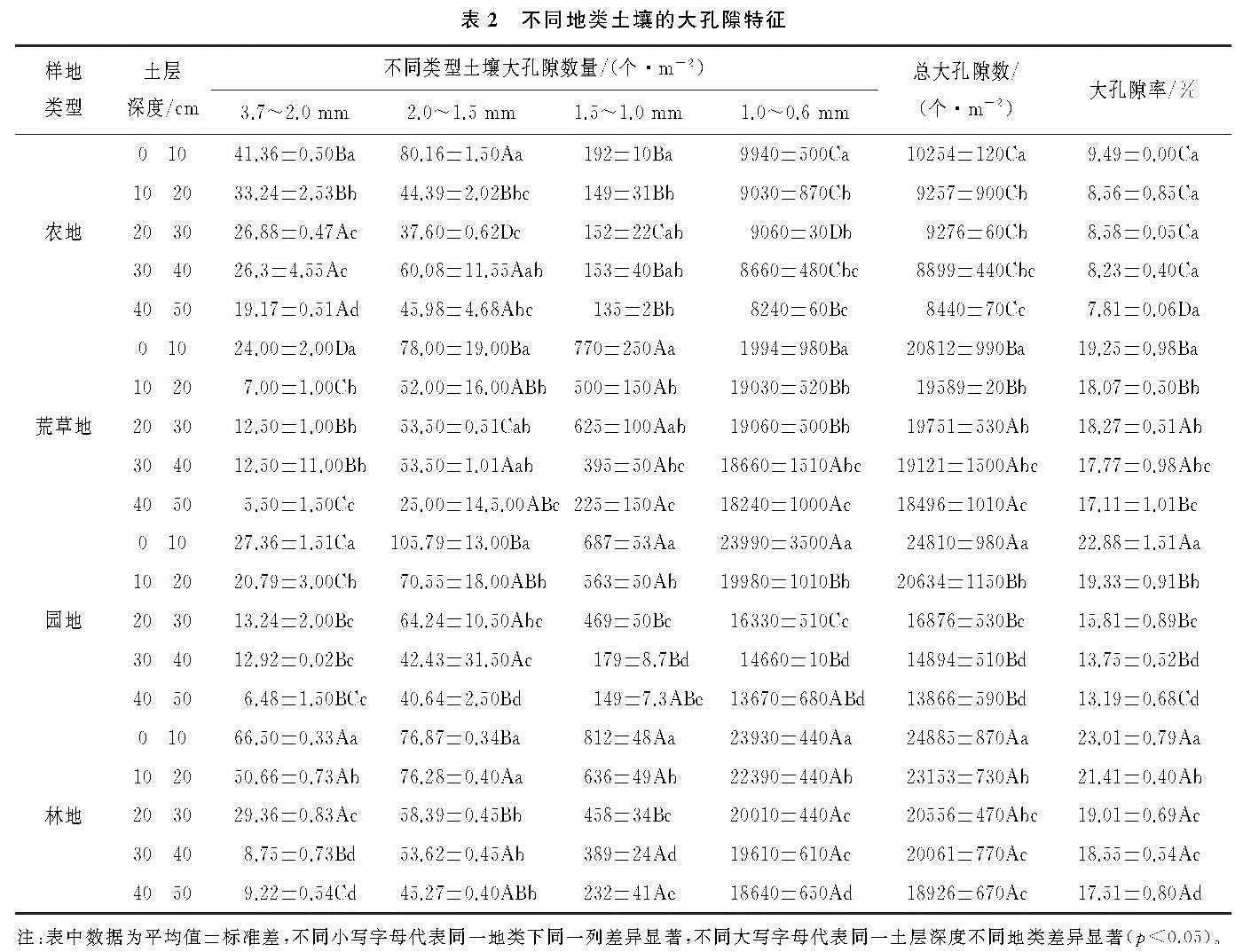
基于水分穿透曲线法对干旱河谷地区4种地类土壤大孔隙的特征和分布与土体中根系特征关联开展探究。干旱河谷区土壤大孔隙的当量半径范围为0.3~3.7 mm,其中最小孔径0.3 mm和水能无限制运移孔隙半径的最低要求相同(d>0.3 mm)[19],孔径范围与Beven[4]、王红兰[13]等的研究结果一致,比时忠杰等[12]分析得到的孔径区间0.4~2.3 mm更宽。当量半径0.3~1.0 mm的孔隙数量最多,孔径>1.0 mm的孔隙数小于总大孔隙数的4.08%。各个地类土壤的大孔隙数量与大孔隙率相比较:林地>园地>荒草地>农地。此外,人类耕种活动毁坏了土壤构造,大孔隙数量急剧减少,其在农地中仅为9.15×10³个/m2,比荒草地、园地和林地的大孔隙密度均值1.912×104个/m2少一半左右。
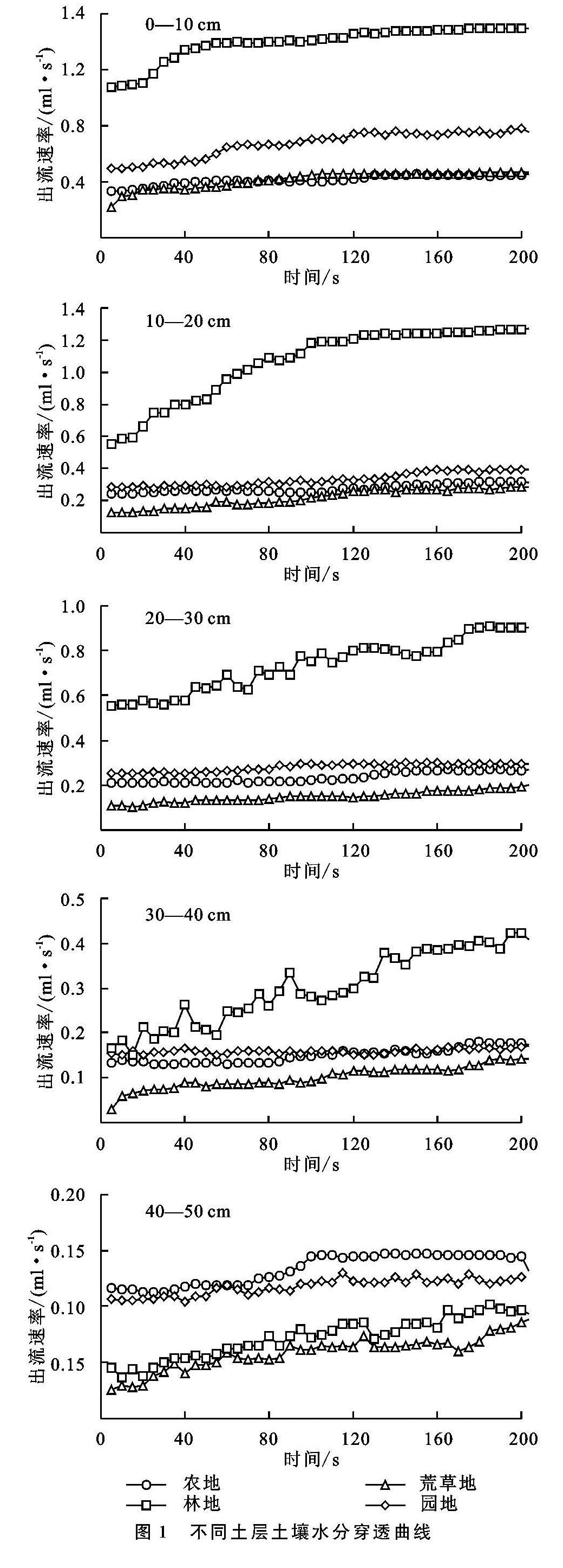
从本研究上看,几种不同地类的土壤水分穿透曲线呈现逐渐增大再趋于稳定的变化趋势,在60~80 s逐渐平稳,所有样地均在40—50 cm土层深度时平稳出流速率最小,4个样地稳定出流速率均值只有0.11 ml/s,而0—10 cm土层深度时的平稳出流速率最大,平均达到0.78 ml/s。其中林地0—10 cm土层的稳定出流速率(1.485 ml/s)为40—50 cm(0.085 ml/s)的17倍。多种因素共同影响土壤出流速率,受到土壤结构、石砾含量[12]、植被根系[17]、根孔[17,23]、动物活动通道[23-24]、人为活动(耕作)[25]以及由于干湿交替[26]和冻融交替[4,26]引发的土壤裂隙等作用影响。
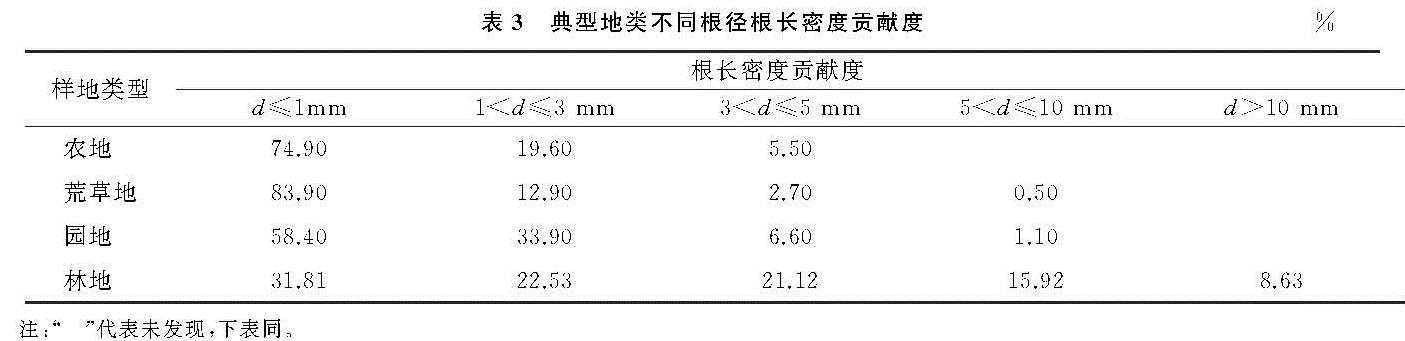
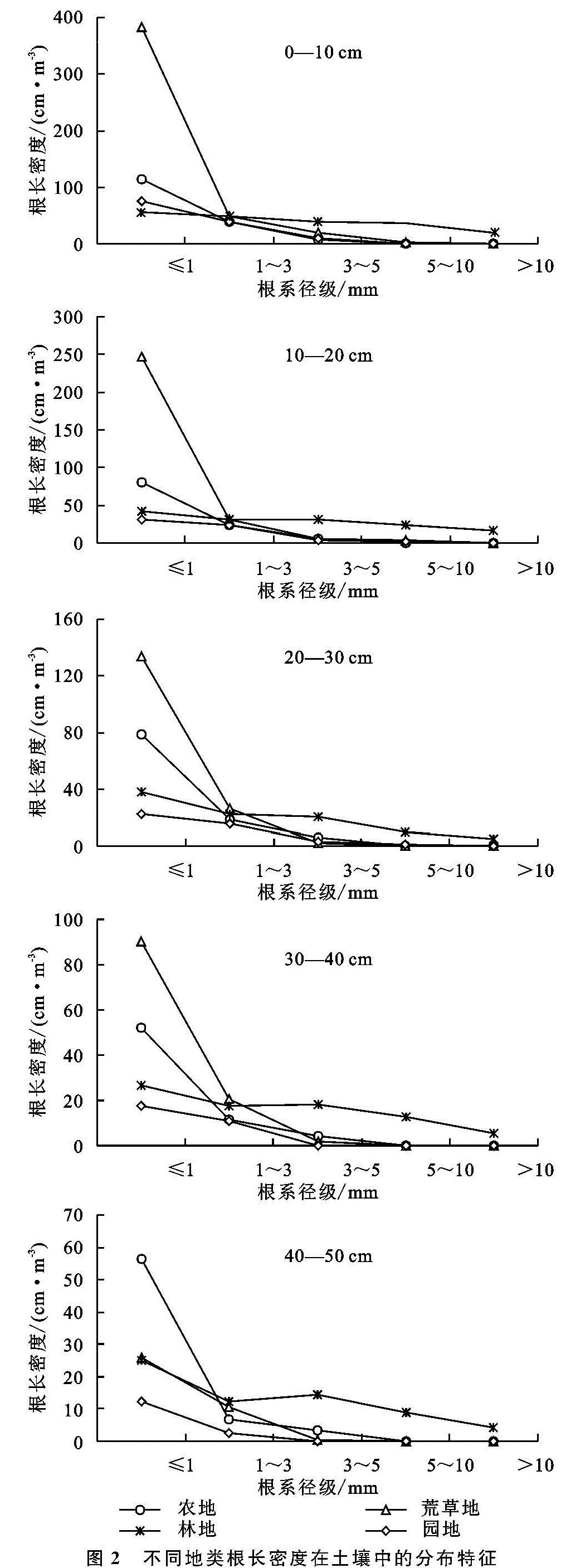
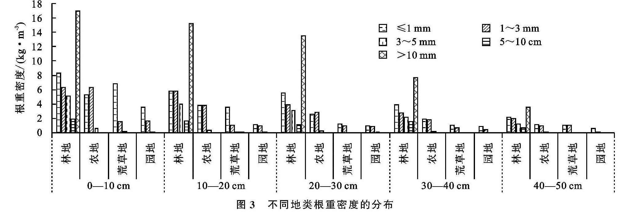
根系特征作为影响土壤大孔隙形成的重要因素之一[17],相关研究表明根系特征可以间接反映土壤内孔隙的数量、直径和大小,土壤大孔隙率随土层深度的增加呈现降低的趋势[27],本文将不同地类植物根长密度和根重密度与土壤大孔隙率进行拟合,得到不同根径的根长密度同根重密度与土壤大孔隙率的相关关系,结果表明细根系根长密度对大孔隙形成的具有贡献度,细根系的根重密度对土壤大孔隙的形成具有显著相关性。随土层深度递增4种地类植物不同根径根长密度及根重密度均降低。主要原因为土壤表层中聚集着大多数根系,根系在深层土壤中占比较少。4种地类根径0<d≤1 mm根长密度对土壤大孔隙的贡献度最高; 其中d≤1 mm,1<d≤3 mm,3<d≤5 mm根径范围内的根重密度都跟土壤大孔隙率具有相关性。农地土壤大孔隙率和0<d≤5 mm根径范围内的根重密度具有极显著相关性(p<0.01); 荒草地则是跟3<d≤5 mm根径范围内的根重密度存在相关性但却不显著(p<0.05); 园地大孔隙率和1<d≤5 mm根径范围内的根重密度具有极显著相关性(p<0.01); 林地大孔隙率跟1<d≤5 mm根径范围内的根重密度具有极显著相关性(p<0.01),与陈晓冰等[28]的研究结果一致。但孙龙等[29]通过研究柑橘地优先流特征表明只有1<d≤3 mm根径范围内的根长密度与染色面积相关性显著,其他径级的根系根长密度与染色面积无相关性,与本文研究不符,其原因除了植物根系不同外,区域不同也是造成这种差异的原因,干旱河谷区土壤感化严重,土壤中石砾含量等也会对优先流的形成产生影响。另外,本研究发现,大于5 mm的根系与大孔隙率均无相关性,此结果与董宾芳[30]的研究成果一致,细根系与土壤大孔隙形成的影响比粗根系更大,细根系生长期短,生长及腐烂后会形成更多的根孔隙通道,促进大孔隙的形成。
土壤大孔隙与土壤优先流的形成密切相关,用来分析干旱河谷地区土壤水分运动和溶质运移规律是合理的。土壤中大孔隙的形成与植被根系及根孔有关联。本文定量分析根系与土壤大孔隙形成的关系,但影响土壤大孔隙形成的因子复杂多变,今后研究土壤大孔隙的重点应放在对土壤大孔隙特征和环境因子对其影响的量化分析上,进一步明晰土壤大孔隙的形成原理,以期为红河干旱河谷地区水资源管理、保护以及植被恢复工作提供理论基础和科学依据。