2.1 不同植被位置下坡面侵蚀输沙来源辨析
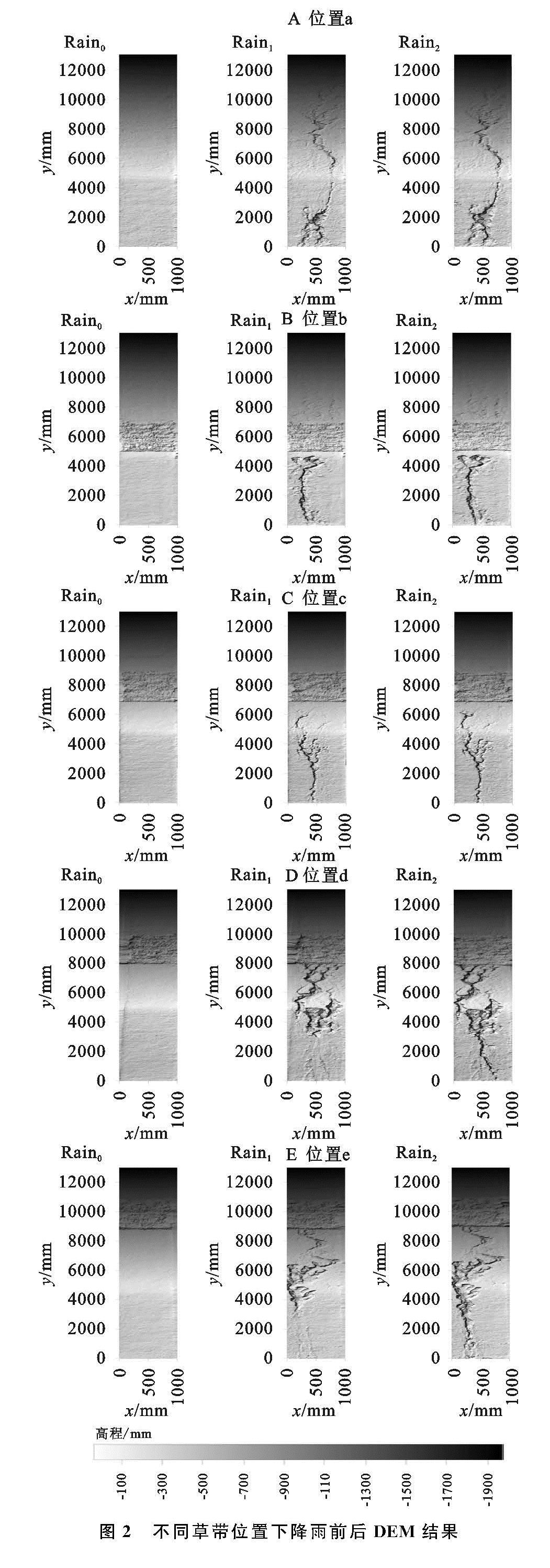
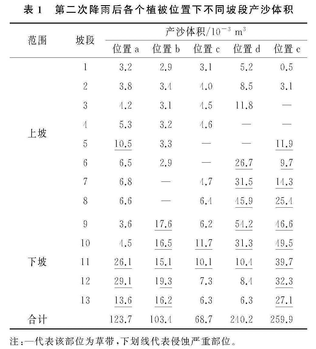
坡面从坡顶至坡底每1 m为一个坡段,上坡为“坡段1—8”的8个坡段; 下坡为“坡段9—13”的5个坡段。以每个坡段产沙体积表征侵蚀量(产沙量),第2次降雨后各坡段产沙体积计算结果见表1。
裸坡条件下,整个坡面的产沙体积为0.123 72 m3,均值9.52×10⁻³ m3/m2。第5坡段的侵蚀量是1.048×10-2 m3/m2,达到坡面产沙量的8.48%,是上坡主要产沙部位。下坡范围内的中部、中下部以及下部(坡段11—13)是整个坡面范围内侵蚀最为严重的部位(图2),3 m长的坡段产沙体积为6.876 ×10⁻² m3,产沙率为29.80 kg/m2,占整个坡面产沙量的55.56%。
位置b条件下,坡面侵蚀总体积为0.103 38 m3,略小于裸坡时的0.123 72 m3,植被具有一定的减缓侵蚀的作用,但作用较弱。位置b下的上坡产沙量在所有试验场次中最少,为1.88×10⁻² m3,占整个坡面产沙量的18.11%,侵蚀程度最低。但下坡产沙量较裸坡却有增加,主要的侵蚀区域集中于下坡整个5 m的坡段,产沙多集中于此(图2),侵蚀体积为8.466×10⁻² m3,产沙率为22.01 kg/m2,占整个坡面产沙量的81.89%,这说明草带调控(减缓)侵蚀的范围有限,仅对上坡有效果。与此相反,位置c条件下,草带布设于上坡60%位置,整个坡面的产沙体积仅为6.872×10-2 m3,小于裸坡时的0.123 72 m3,说明植被种植位置较为合适,就可以具有较好的减缓侵蚀的作用,其调控范围覆盖整个坡面。上坡产沙体积仅为2.719×10⁻² m3,占整个产沙量的39.57%; 下坡产沙量仅为4.153×10⁻² m3,占整个坡面的60.43%,侵蚀程度最低。只有下坡中上部(坡段10)和中部(坡段11)产沙量较大,是坡面产沙的主要来源部位(图2),其2 m的坡段的侵蚀体积为2.179×10⁻² m3,产沙率仅为14.16 kg/m2,占整个坡面产沙的31.71%。
位置d条件下,整个坡面的产沙体积达到0.240 16 m3,远大于裸坡,侵蚀的程度增强,草带减缓侵蚀效果较差,甚至失去调控效果。此时上坡、下坡的侵蚀程度均较为严重。从下坡中部至上坡中下部6 m范围内的侵蚀程度十分严重(图2),侵蚀产沙多来源于此,其产沙量达到0.199 87 m3,产沙率为43.30 kg/m2,占坡面产沙量的83.22%。
位置e与位置d侵蚀情况类似,但侵蚀剧烈程度强于位置d,整个坡面的产沙体积达到了0.259 86 m3,远远大于裸坡,植被减缓侵蚀的效果最差。此时从下坡下部一直延伸至上坡中部9 m范围内的侵蚀程度达到试验范围内峰值,侵蚀严重,其产沙体积高达0.256 25 m3,产沙率增至37.01 kg/m2,占坡面产沙总量的98.61%,侵蚀程度和产沙量达到峰值。
2.2 不同植被位置调控坡面侵蚀输沙作用辨析
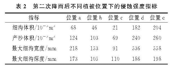
对不同植被位置下的DEM进行提取[17],测量、计算第2次降雨后的产沙体积等侵蚀强度指标(表2)。与裸坡相比,位置b条件下的细沟体积和产沙体积分别减少了32%,16%,细沟宽度减少30%,细沟深度降低39%。而位置c与裸坡相比各个指标均大幅降低,细沟体积降低69%,产沙体积降低44%; 细沟宽度减少36%,深度降低58%,达到谷值。位置d和e的情况则刚好相反,较裸坡相比,侵蚀程度大幅加剧,位置d的细沟体积和产沙体积分别增加1.67倍和94%,最大细沟深度和宽度分别增加7.5%和1.46倍; 位置e的产沙体积和细沟体积分别增加1.1,1.98倍,细沟深度增加14%,宽度增加1.56倍达到峰值。
对比5种植被位置,草带位置d和e下的细沟侵蚀量占总侵蚀量的76%,78%,远大于其他位置的情况,这与文献记载结论一致[18]。说明草带位置d,e条件下,细沟侵蚀成为了主要的侵蚀方式,细沟侵蚀部位(侵蚀产沙来源)多处于下坡下部至上坡下部(图2)。草带位置b和c下的细沟侵蚀量达到谷值,不到总侵蚀量的45%,说明此时主要的侵蚀方式是击溅侵蚀和片蚀,而不再是细沟侵蚀,细沟侵蚀也仅仅发生在下坡下部的小区域内(图2)[19]。
在合理的位置条件下,尽管草带没有改变侵蚀部位,但能够减缓侵蚀,降低了侵蚀强度。值得注意的是,位置b和c的草带减缓侵蚀的程度和作用范围是不同的。位置b的草带调控侵蚀的效果稍弱于位置c,调控范围仅限于上坡,其范围内的产沙量很小; 但下坡范围内产沙量却超过了裸坡。此时下坡成为侵蚀的主要部位,产沙体积为8.466×10⁻² m3,占整个坡面的82%。位置c时草带调控侵蚀的效果更加明显,调控侵蚀范围从下坡至上坡,有效减少了坡面所有坡段的产沙水平,侵蚀强度指标处于谷值(图2和表2)。将坡面产沙的主要部位控制在下坡中上部和中部2 m的坡段,使得产沙率仅为14.16 kg/m2,产沙体积仅为2.179×10-2 m3,占坡面产沙的31.71%。
尽管位置d,e的植被减缓侵蚀效果、范围不同,但产沙主要部位均是由下坡中部、中下部逐渐向上扩展至下坡上部至上坡下部、中部。同时由于位置d,e时草带布设相对靠上,留给了植被下部更多的裸坡与出口直接相连,流速快速增长,侵蚀能力急剧增大。加之植被过滤,含沙量有所降低,径流携运泥沙能力增强[20],使得侵蚀程度(产沙量)增加,产沙的主要部位也因此发生改变,各个侵蚀指标较裸坡均有一定程度的增加(表2)。
综合以上分析,草带种植于坡面,下坡始终是坡面产沙的主要部位。植被种植位置偏于上坡上部会在一定程度上加剧侵蚀,使得产沙量达到峰值; 但由于植被减缓侵蚀的部位和调控的范围有所不同,侵蚀加剧的程度和泥沙主要来源存在不同。草带种植位置偏于坡面下部,都会减缓侵蚀,产沙量为最低; 但减缓的侵蚀范围不同,侵蚀主要的部位也会不同。草带种植于上坡底部,植被减缓侵蚀的范围有限,仅可以有效降低上坡范围的侵蚀,而下坡的产沙量较裸坡有增长(图2)。草带种植于上坡中下部,植被减缓侵蚀的范围达到整个坡面,可以在较大程度上抑制流速的增长,减缓整个坡面的侵蚀强度,使产沙量达到最低。