2.2.1 生态系统服务功能重要性评价
与生态敏感性评价生态系统服务功能重要性与生态敏感性评价是生态安全格局成功构建的基础。生态系统服务功能指生态系统为满足人类生存所提供生态空间的能力,本研究从水源涵养、生物多样性、水土保持三方面展开研究; 生态敏感性指生态系统因人类活动所引发生态变化的敏感性大小,本研究从水土流失与地质灾害两方面展开研究[15]。
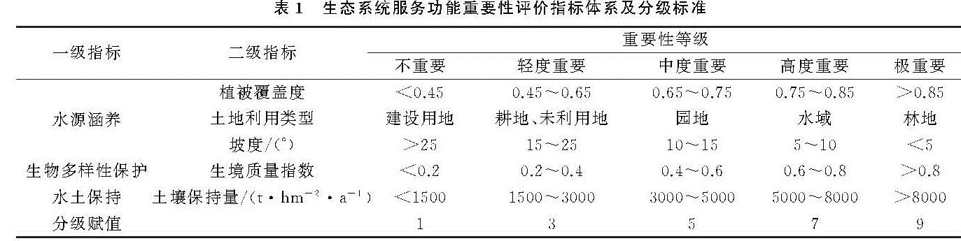
(1)生态系统服务功能重要性评价。水源涵养功能指生态系统用于协调区域水资源平衡的重要生态系统服务功能,本研究选取植被覆盖度、土地利用类型、坡度三项指标展开水源涵养功能重要性评价。首先,将三项指标参考白杨、初东等[16]研究的分类标准进行五级赋值; 其次,利用几何平均数模型计算水源涵养重要性指数,利用自然断点法将评价结果分为5个等级,具体分级标准见表1。
表1 生态系统服务功能重要性评价指标体系及分级标准
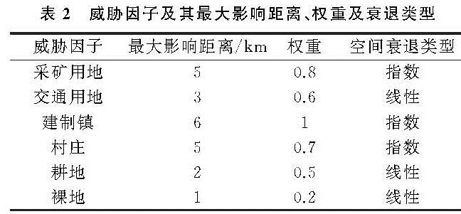
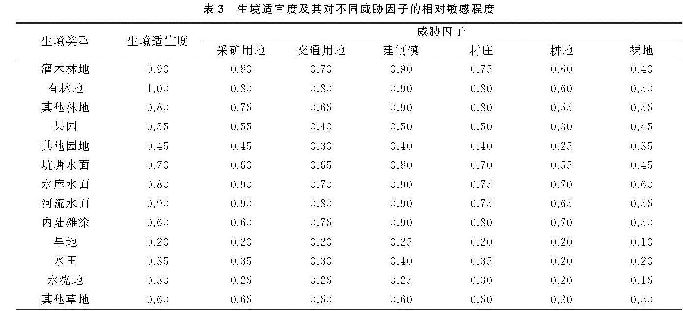
生物多样性保护功能指生态系统为物种生存与繁衍所提供场所与保护作用的能力。生物多样性与生境质量存在显著的正相关性[17],因此本研究以Invest模型计算的生境质量大小代表生物多样性保护功能的重要性,模型的相关参数参照Invest模型(3.2.0)使用说明书[18]与相关研究[19-20]综合确定,具体参数见表2—3。
根据公式(1)计算得出研究区生境质量大小,其范围在0~1之间,将其等间隔分为5个等级。计算公式如下[12]:
Qxj=Hj[1-((Dzxj)/(Dzxj+k2))](1)
式中:Qxj为生境类型j中栅格单元x的生境质量; Hj表示生境类型j的生境适宜度; Dxj表示生境类型j中x栅格单元的生境退化度; z为归一化指数,默认设置2.5; k为半饱和常数,通常为生境最大退化值的一半,取值0.5。
水土保持功能指生态系统保持区域水土平衡、减少因水蚀导致土壤侵蚀的重要生态系统服务功能。本研究利用修正通用土壤流失方程(RUSLE)计算土壤保持量的大小,根据土壤保持量的大小判断水土保持功能的强弱,按照表1中的规则将水土保持量分为5个等级。计算公式如下:
Ac=R×K×LS×(1-C×P)(2)
式中:Ac为土壤保持量[t/(hm2·a)]; R为降雨侵蚀力因子[MJ·mm/(hm2·h·a)],采用查良松等[21]计算巢湖流域降雨侵蚀力因子的经验公式计算; K为土壤可蚀性因子[t·hm2·h/(MJ·mm·hm2)],根据研究区土壤类型图与门明新等[22]学者的研究结果,进行对比赋值; R,K两个因子需在其计算结果的基础上分别乘以17.02,0.131 7以转为国际制单位; LS为坡度坡长因子(无量纲),坡度因子采用刘宝元[23]的坡度公式计算,坡长因子采用Wischmeier[24]提出的公式计算; C为植被与经营管理因子(无量纲),采用蔡崇法等[25]学者建立的模型计算; P为水土保持措施因子(无量纲),根据相关研究结果[26]与研究区实际情况对六大地类进行赋值,未利用地:1,林地:0.8,园地:0.8,耕地:0.5,建设用地:0,水域:0。
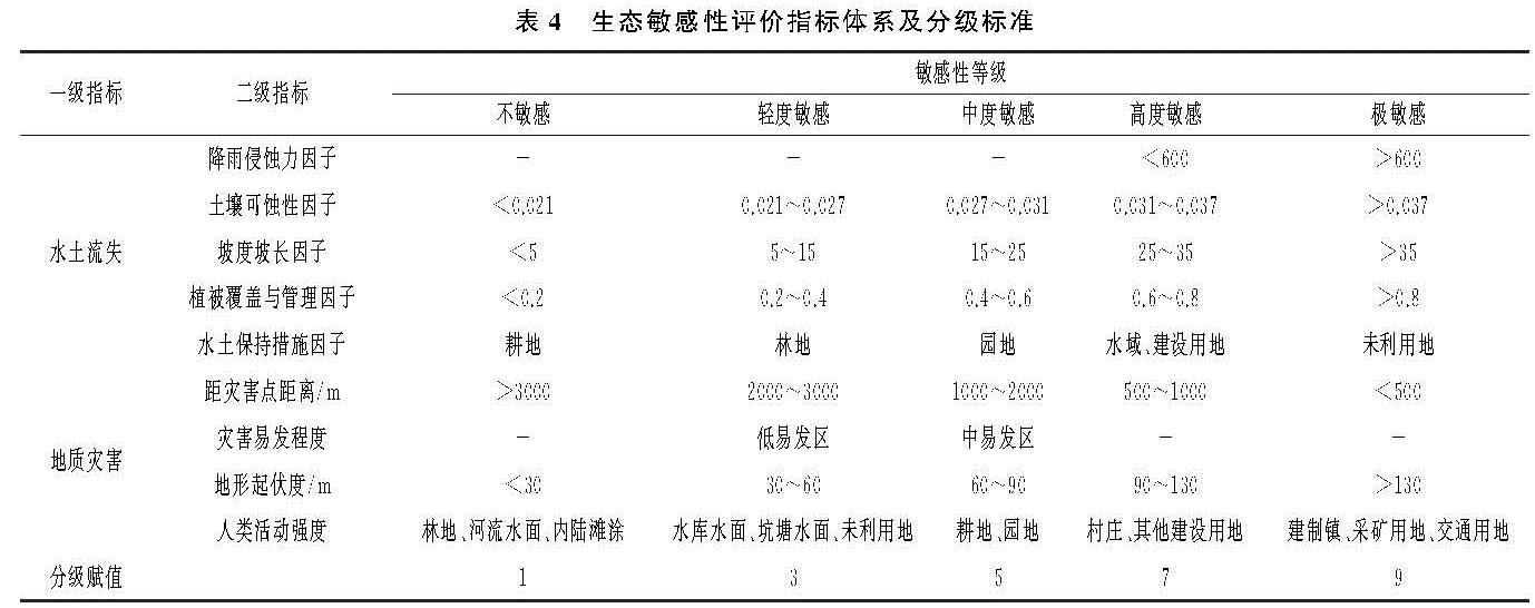
(2)生态敏感性评价。水土流失敏感性评价可以有效评估因人类活动引发水土流失的可能性大小,本研究以RUSLE模型为基础,展开水土流失敏感性评价(各指标含义同上); 通过评价地质灾害敏感性以识别地质灾害易发区,达到加强预防的目的,本研究选取距灾害点距离、灾害易发程度、地形起伏度、人类活动强度四项指标对青龙县地质灾害敏感性展开评价。首先,将各指标参照周锐、王新军等[27]学者的研究及《生态保护红线划定指南》[28]进行分级赋值,评价因子及其分级标准见表4; 其次,利用几何平均数模型计算水土流失、地质灾害敏感性指数,依据自然断点法将敏感性指数分为5个等级。
(3)几何平均数模型。针对单项生态系统服务功能重要性与生态敏感性,本研究将评价指标进行五级赋值,参照杨远琴等[29]研究,利用几何平均数模型通过计算其单项重要性与敏感性指数来判断其生态安全水平,计算公式如下:
式中:Sj为评价单元生态重要性/敏感性指数; j=1,2,3,即分别对应上文中水源涵养、水土流失、地质灾害三项评价因子; Cij为第j项评价因子第i项指标的生态重要性/敏感性分值; n为第j类评价因子对应的评价指标个数。
2.2.2 生态安全格局构建
(1)生态源地的识别。生态源地是生态过程向外扩散的起点,利于维护区域生态安全[30]。本研究选取水源涵养、生物多样性保护、水土保持三项生态系统服务功能均属于极重要等级的地区作为研究区生态源地。具体利用GIS空间分析工具,依据“木桶原理”提取三项生态系统服务功能极重要区,通过合并临近斑块、删除零星碎小斑块等处理,取并集得到研究区生态源地。
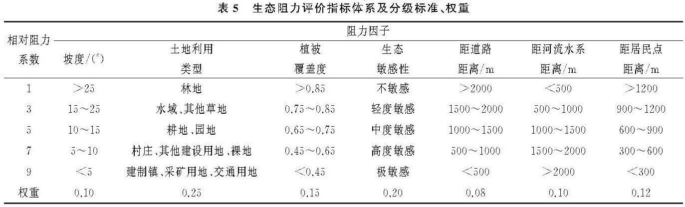
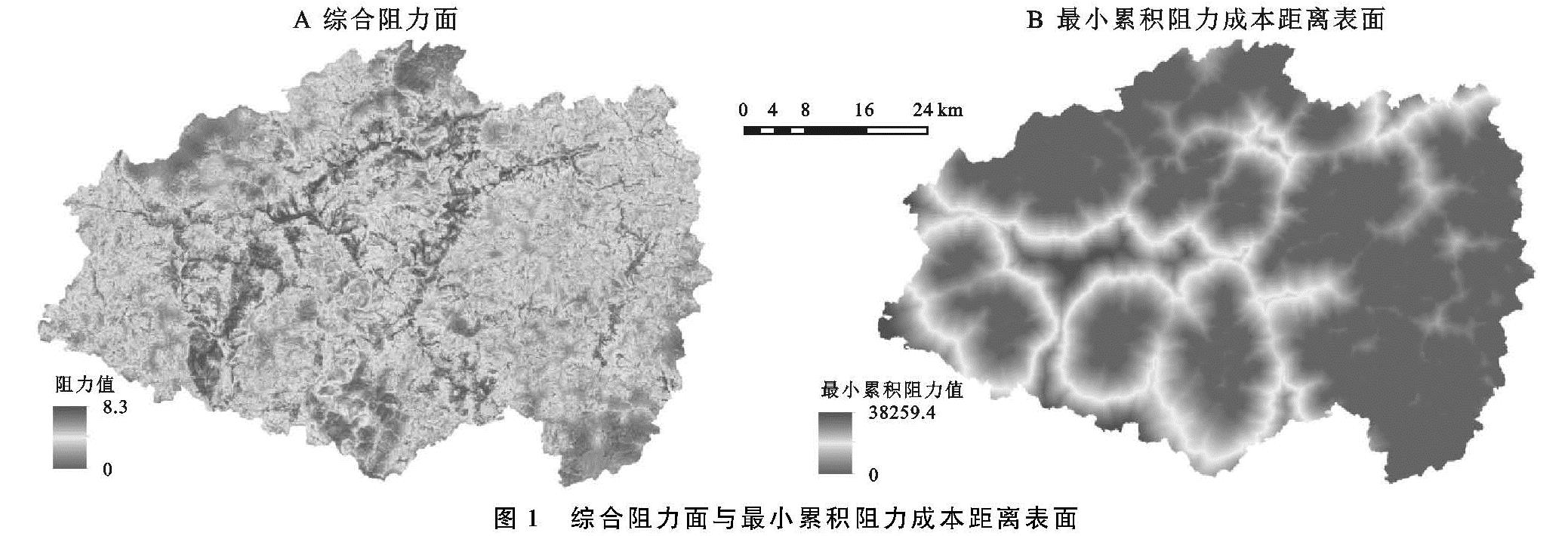
(2)综合阻力面的构建。生态系统中物质和能量的流动以及物种的迁徙都需要通过克服阻力来实现[17]。结合研究区生态基底,本研究利用综合生态敏感性评价结果构建综合阻力面,同时考虑自然与社会因素,最终选取7个阻力因子,通过加权求和的方法构建综合阻力面。其中,各阻力因子的权重依据特尔斐法确定,综合生态敏感性通过对单项敏感性结果取最大值镶嵌的方法得到。各阻力因子及其分级标准与权重见表5。
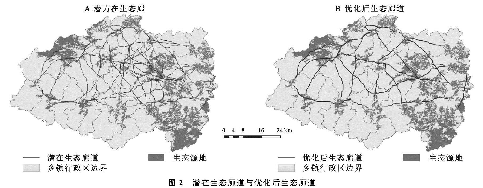
(3)生态廊道的构建。生态廊道是连通生态源地,维持能量流动与物种交流的重要通道[31]。依据MCR模型及其原理,计算源地与目标斑块间的最小累积阻力成本距离,依据该结果可以得到生态安全等级空间分布情况,并且可以进一步计算生物的迁徙路径,即生态廊道。MCR模型计算公式如下:
MCR=fmin∑i=mj=n(Dij×Ri)(4)
式中:MCR为最小累积阻力值; Dij为从生态源点j到空间单元i的距离; Ri为空间单元i的阻力系数。
根据公式(4),将综合阻力面作为MCR模型的成本数据,利用GIS空间分析模块中的费用距离工具,计算每个像元到成本面上最近源地的最小累积阻力成本距离。接着利用成本路径工具生成潜在生态廊道,由于该工具生成的成本路径是双向的,为了去除冗余,需将各廊道的累积阻力值量化,即以数值的形式将各廊道的累积阻力值提取出来,去除相同、相似廊道,并保留低阻力廊道,最终得到研究区优化后的生态廊道。
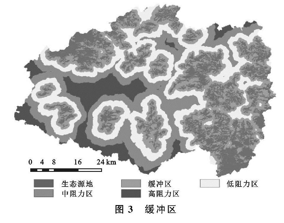
(4)缓冲区的识别。缓冲区是生态源地外围为物种生存提供保护与恢复功能的生态潜力区。依据最小累积阻力面,利用自然断点法划定除去生态源地的4个不同等级生态安全水平的缓冲区。缓冲区作为物种修复的调节地带,需要执行严格的保护政策。随着源地向外扩散,最小累积阻力值逐渐增加,代表生态保护用地扩张的阻力值越来越大,生态敏感性逐渐变弱,可进行合理的开发建设。
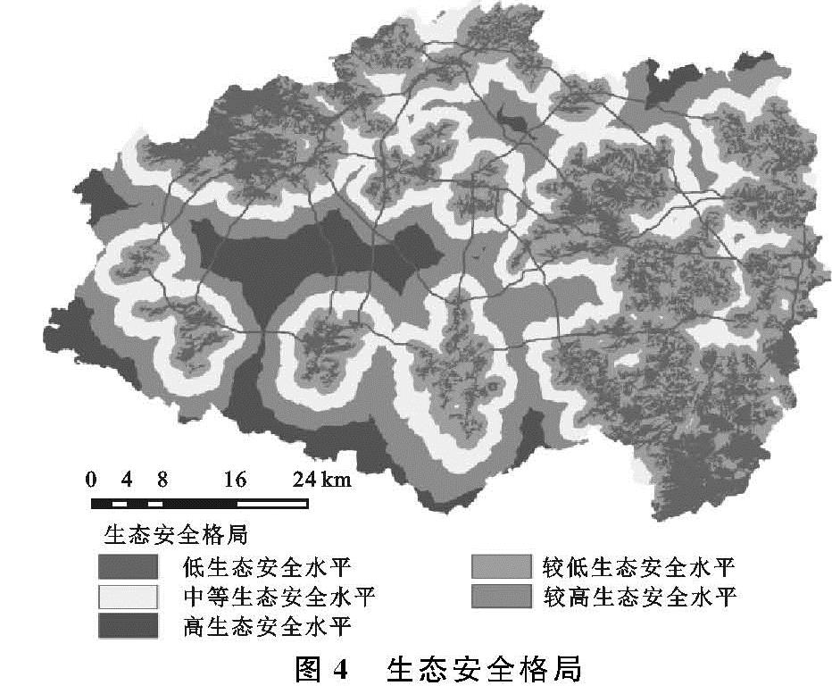
(5)综合生态安全格局构建。本研究构建的生态安全格局组分包括:源地、廊道、缓冲区。缓冲区的等级代表了生态安全格局水平的高低情况,因此依据缓冲区的划定结果综合划定研究区不同安全水平的生态安全格局。同时,考虑到土地利用冲突识别体系中生态廊道与生态源地的同等重要性,在构建综合生态安全格局时,创新性的将生态廊道一定宽度内的区域纳入保护范围。参考相关研究成果[31-32],并考虑青龙县生态廊道的生物多样性保护、大型生物迁移通道、隔离、绿带等功能,最终选取200 m作为生态廊道的保护宽度,将生态廊道保护区列为低生态安全水平行列。综合考虑缓冲区与生态廊道划定结果的基础上,最终划定青龙县低、较低、中等、较高、高5个安全水平的生态安全格局。
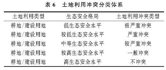
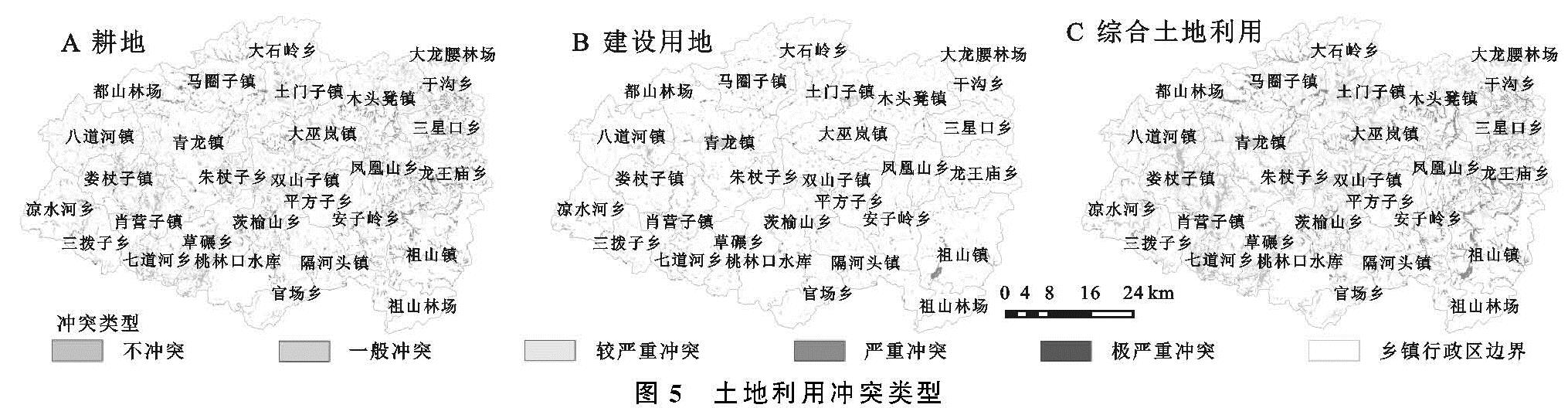
2.2.3 土地利用冲突识别与分类
本研究分析生态安全视角下土地利用冲突的空间分布特征。基于以上研究,定义生态安全视角下土地利用冲突为:多利益主体因农业耕作、城镇扩张等经济建设活动对生态安全空间的不合理占用,由此引发的土地资源竞争结果。具体体现为耕地、建设用地对生态安全用地的占用。构建土地利用冲突识别体系:首先,根据引发土地利用冲突的人类经济活动主导用地类型,将土地利用冲突定义为耕地、建设用地、综合土地利用冲突三大类型,耕地、建设用地冲突分别指农业耕作、开发建设活动对生态安全用地的占用,综合土地利用冲突是耕地与建设用地冲突叠加效应的综合体现; 其次,确定土地利用冲突类型,即利用GIS的空间分析功能,根据耕地、建设用地分别对低、较低、中等、较高、高安全水平空间格局的占用依次将土地利用冲突划定为极严重、严重、较严重、一般、不冲突5个类型,具体划分标准见表6。生态安全水平的等级越低,其生态重要性越高,越应执行严格的保护政策,禁止人类建设开发活动,因此产生土地利用冲突时造成的后果越严重。