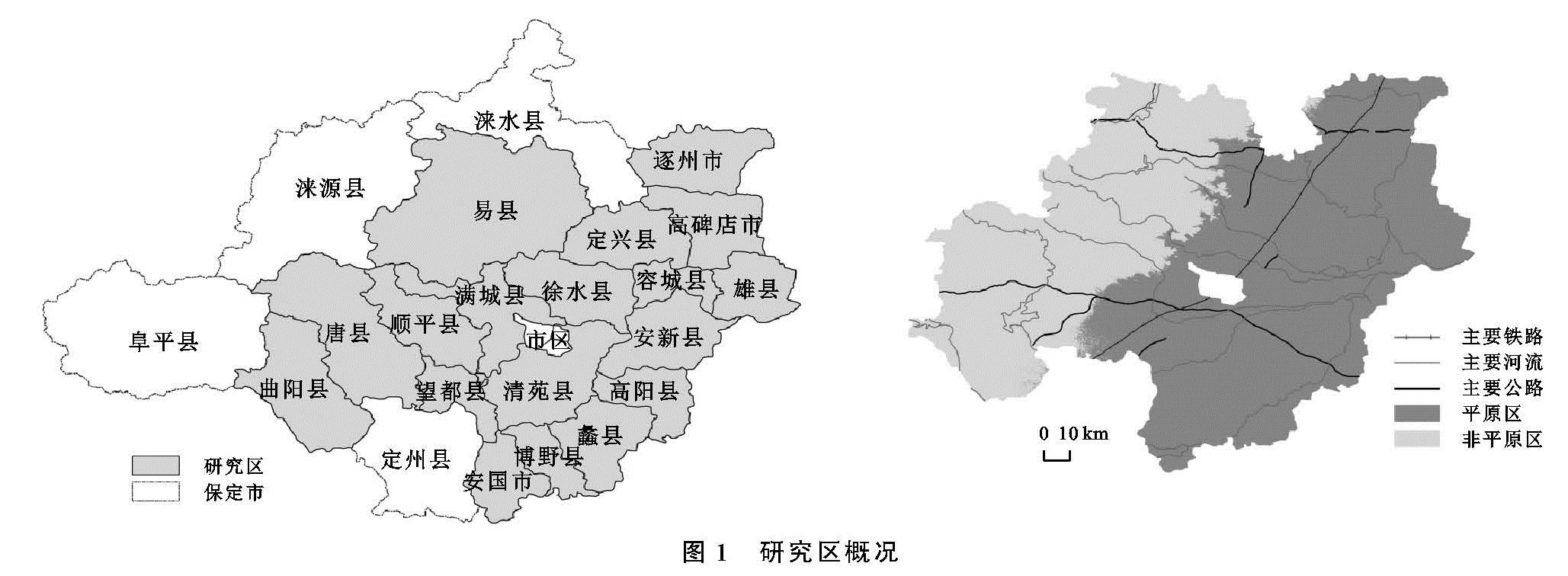
3.3.1 影响因子筛选
随着区域经济的快速发展,农村居民收入水平不断提高,在解决温饱问题之后,对美好生活的向往与追求使得农民迫切要求改善自身的居住环境,最明显的表现就是扩大自己的住房面积“住的更宽敞”,这一过程加大了对固定资产的投入; 此外,随着城乡一体化进程的推进,城镇与农村的差异化减小,城镇的一些社会服务进入农村,此时农村居民也有经济能力去追求和体验丰富多彩的社会服务,因此这样的行为又进一步刺激了农村区域产业非农化的快速发展,扩宽了农村居民获取收入的途径。参照Qu[7]的研究成果,选取人均GDP(F1)、农村居民人均纯收入(F2)、固定资产投资(F3)和产业非农化率(F4)作为经济影响因子,来探测经济因素对农村居民点格局演变的驱动作用。
农村居民点的格局演变除了受到经济发展的影响,也受到社会生活的浸化。农村社会生活的发展状况可以从农民拥有的生产资料以及农村人口和城镇人口分布上加以衡量。在经济发展水平比较低的小农经济时代,农民为了解决生活中最为基本的温饱问题,通常会把农村居民点选址与耕地资源联系起来,耕地资源生产条件又与粮食产量相挂钩; 随着城镇化进程的快速推进,大量的农村人口向城镇转移,带动着农民生活方式的变革,一些农民离开传统的独立独户的院落,住进统一建设的居民小区里,驱动着农村居民点格局发生变化; 人口增长最直接的表现是对粮食和住房需求的增加,住房需求影响着农村居民点的布局。因此,选取人均耕地面积(F5)、人均粮食产量(F6)、城镇化率(F7)和人口密度(F8)作为社会影响因子[7]。
3.3.2 地理探测器探测结果
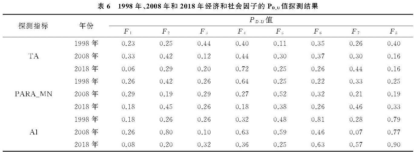
根据地理探测器模型的计算公式将每一个影响因子通过K-means分类算法把全域划分为9个等级区。运用模型分别探测影响因子对农村居民点规模、形状和分布上的影响作用力大小,分别用斑块面积(TA)、斑块平均周长面积比(PARA_MN)和聚集度(AI)来表征,结果见表6。
表6 1998年、2008年和2018年经济和社会因子的PD,U值探测结果
依据模型运算结果,1998—2018年:(1)农村居民人均纯收入、产业非农化率和城镇化率对农村居民点的规模、形状和分布均产生显著的影响,只是其对规模、形状和分布的地理探测PD,U峰值出现的时间有差异; 其他因子对农村居民点空间格局的影响是片面的,例如人均粮食产量对农村居民点分布的地理探测PD,U值最高达到0.81,但对形状的地理探测PD,U值最高值只有0.32。(2)经济和社会因子对农村居民点规模、形状和分布的影响具有一定的独立性和交叉性。例如产业非农化率对规模的影响作用力逐渐增大,在2018年产业非农化率对规模的地理探测PD,U值达到0.72,但产业非农化率对形状的地理探测PD,U值逐渐减小,对分布的地理探测PD,U值先增大后减小; 人口密度和人均粮食产量对农村居民点分布的影响作用力大小比较稳定,其地理探测PD,U值均保持在0.40以上,但其对规模和分布的地理探测PD,U值最高不超过0.40。(3)经济和社会因子对研究区农村居民点空间布局的影响是多样的、复杂的,比如城镇化率对农村居民点分布的地理探测PD,U值在2008年只有0.07,但在2018年PD,U值达到0.57; 人均GDP对农村居民点规模的地理探测PD,U值由0.33降为0.06。
除去灾害等破坏性自然因子,自然因素作为能够持续影响农村居民点格局的因素,产生的作用是潜移默化的,与此不同的是,农村居民点格局能够对经济和社会因素的某些因子产生相对迅速的反映,比如固定资产投资的增加直接影响到农村居民点格局的变化。此外,经济和社会因素易受到国家宏观政策的影响,地理探测PD,U值难免出现为大幅度变化的情况。总结来看,经济和社会因素对研究区农村居民点空间格局的影响存在综合性、多样性和复杂性,经济和社会因素中均存在对农村居民点规模、形状和分布均产生显著影响综合性因子,比如经济因子农村居民人均纯收入、产业非农化率和社会因子城镇化率,其他因子对农村居民点空间格局的影响具有一定的交叉性和片面性。