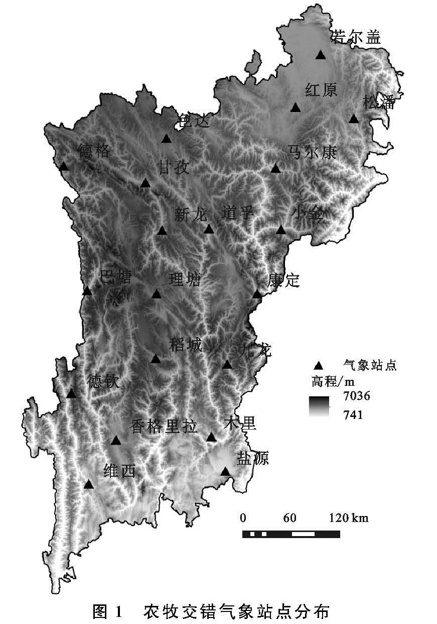
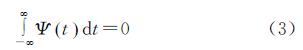
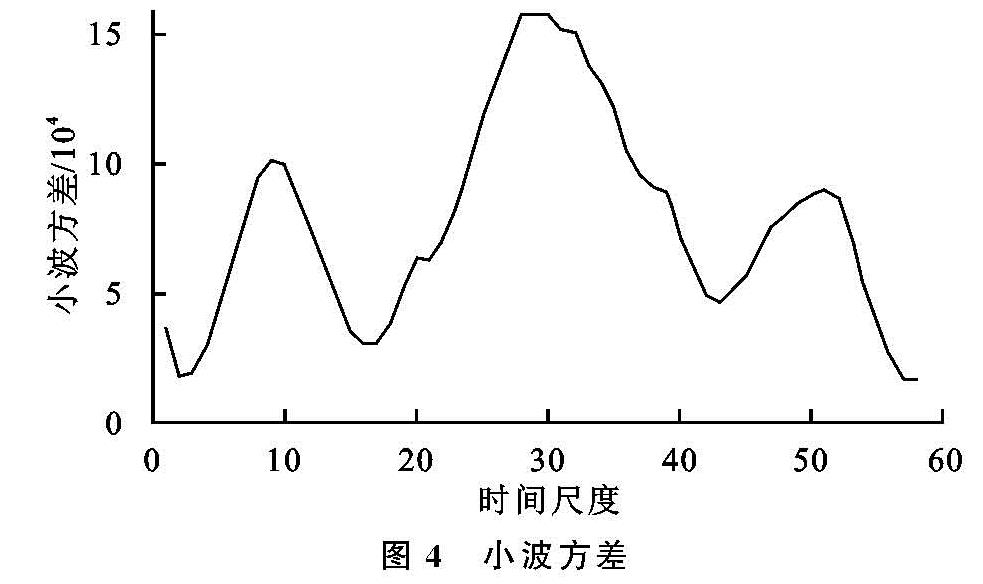
本文以南方农牧交错带1960—2017年逐月降水数据为基础,分别计算了1个月、3个月、6个月、12个月4个时间尺度的SPI值(分别用SPI1,SPI3,SPI6,SPI12表示),其主要原因是本文主要从短时间尺度和长时间尺度两方面来表征该区域的旱涝发生的时间特征与旱涝灾害的严重程度,其中SPI1,SPI3是以月和季节为尺度下旱涝灾害发生的特征,而SPI6,SPI12能够表征较长时间尺度下其发生的频率。
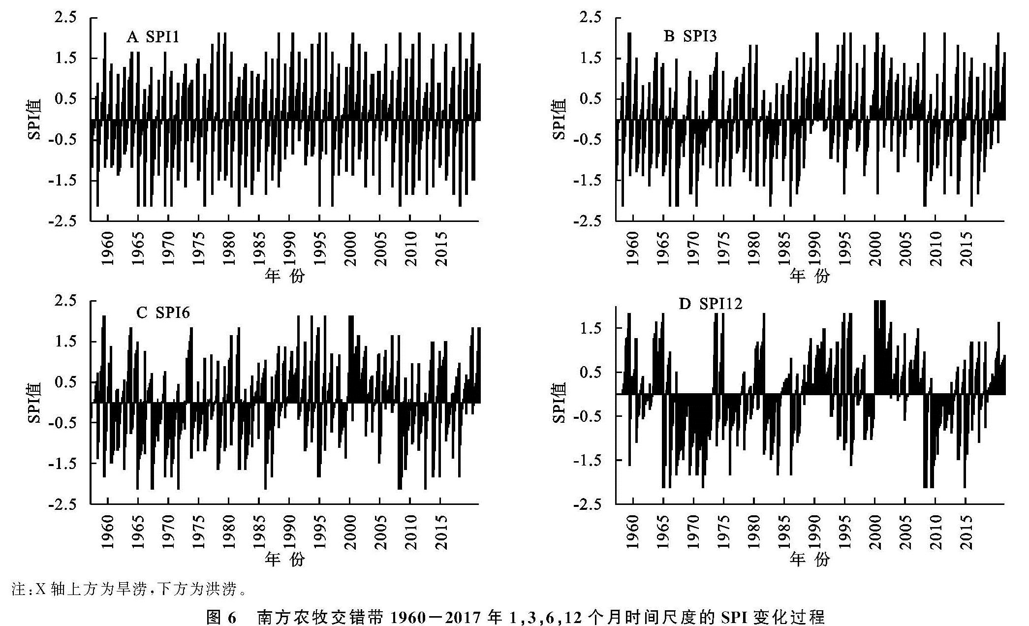
图6 南方农牧交错带1960-2017年1,3,6,12个月时间尺度的SPI变化过程
SPI1与SPI3是较短时间周期内旱涝尺度分析,受短时间内的降水影响较大,数值波动较为频繁,能够较好的反映短时间内的旱涝变化情况。在SPI1序列图中,1961年5月、1978年11月、1979年12月、1987年9月、1989年10月、1993年8月、1994年3月、1998年7月、2005年2月、2008年1月、2014年6月、2016年4月SPI1值达到2.12,达到了极度洪涝的程度,而在1961年9月、1967年4月、1968年10月、1969年2月、1971年3月、1972年8月、1977年6月、1982年5月、1994年7月、1996年12月、2006年1月、2015年11月SPI1值降到了-2.12,旱情达到了极端干旱的程度,由此可以反映出,SPI1能够较好地反映在短时间尺度下(月尺度)旱涝发生的严重程度及其短时间尺度下特征。
从SPI3序列图中可以看出,在1961年的夏季、1968年的冬季、1969年春季、1972年的夏季、1983年的夏季、1986年的夏季、2006年的夏季和秋季、2013年的冬季、2015年的秋季SPI值为-2.11,表明在此几个年份的该季节旱涝程度达到了极端干旱的程度,旱情严重; 而在1961年夏季、1989年秋季与冬季、1993年秋季、1994年春季、1998年夏季与秋季、2005年冬季、2008年冬季、2016年春季的SPI值为2.11,表明在这些年份的季节中涝情严重,达到了重涝的程度,降水量极为丰富从而导致极端湿润。因此从关于SPI3的旱涝情况分析中可以看出,SPI3能够很好地反映旱涝发生的季节变化特征。
SPI6和SPI12是较长时间尺度下的旱涝变化情况,在此种较长时间尺度下旱涝的周期变化特征较为明显,根据上述的SPI6序列图可得,南方农牧交错带地区在1961年为极度洪涝年份,1999年、2017年为重涝年份,1974年、1995年、2000年、2004年、2010年、2016年为中度洪涝年份,1978年、1981年、1985年、1990年、2001年、2002年、2003年、2012年为轻度洪涝年份。1986年为极度干旱年份,1983年、1987年为重度干旱年份,1963年、1967年、1969年、1977年、1979年、1980年为中度干旱年份,1993年、1982年、1971年、1972年、2009年、2007年、1988年、1966年、1970年为轻度干旱年份。
由SPI12序列图可以得知,南方农牧交错带地区20世纪80,90年代偏涝,在该时间段内涝灾发生的频率较高; 20世纪70年代偏旱,在该时间段内旱灾发生的频率较高; 20世纪60年代、90年代旱涝灾害交替出现,但是60年代发生的旱灾频率要高于涝灾频率,90年代发生涝灾的频率要高于旱灾的频率,所以60年代整体偏旱,干旱化趋势明显,90年代整体偏涝; 进入21世纪之后旱涝发生的频率有所减少,2006年、2007年、2009年、2011年处于偏涝年份、2000年、2003年、2010年、2017年处于偏旱年份,其于年份发生旱涝灾害的程度从SPI12的指示状态来看都属于正常的年份,表明进入21世纪,南方农牧交错带地区的旱涝灾害发生的频率有所减少,降水量趋于正常,这种现象的发生是由于多种因素影响而形成的。通过对SPI12序列图的分析发现,SPI12对长时间尺度内的旱涝灾害程度的变化具有良好的判断作用,其不仅能够较为准确的判断出旱涝变化情况的年际变化特征,还能够很好的反映研究区域内旱涝灾害的发展趋势,对于预防旱涝灾害有一定的指导作用。从SPI12序列值可以看出,南方农牧交错带地区总体在21世纪之前偏涝,在2000年之后的前几年涝灾减少,发生旱灾的频率增加,但是在2010年之后的SPI12指数值趋于正常,且保持平稳,旱涝灾害减少,指数趋于平稳。