2.1 土壤有机质描述性统计分析
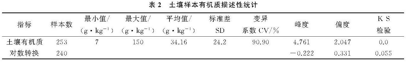
从土壤有机质描述性统计分析(表2)可以看出采样点的土壤有机质含量在7~150 g/kg,标准差为24.2,平均值为34.16 g/kg。
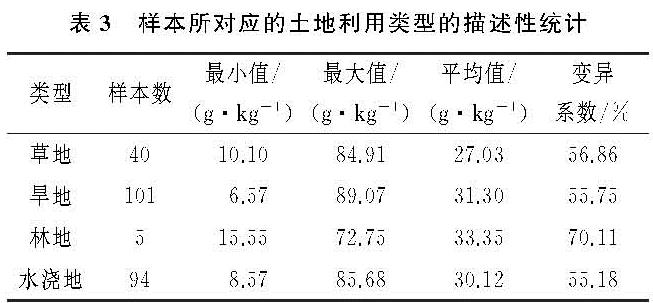
CV为变异系数,根据CV<10%为弱的变异性,10%~100%属于中等变异,CV>100%是强变异性,可知总体样本CV为90.90%,属于中等变异强度; 偏度为2.047,属于右偏态,峰度4.761,不是特别陡峭; 在K-S检验中,p的值等于0,说明其不呈正态分布,不能直接用于空间插值研究,所以需要进行对数转换,转换后其p值为0.055,大于0.05,可以用于地统计分析; 除此之外根据表3对各土地利用类型的统计,土壤有机质都处于中等变异水平,林地的变异程度大于其他3种土地利用类型。
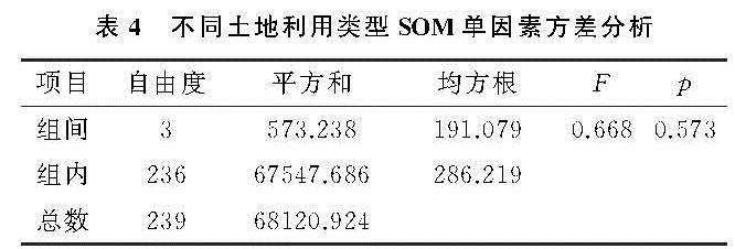
不同土地利用类型的土壤有机质单因素方差分析(表4)表明,由于p>0.05,四组土地利用的SOM并未存在很大的差异,故SOM值是属于同一总体的,使水浇地、林地、旱地、草地的SOM值可以视为同一区域化变量,不用在插值前消除由这些类所引起的SOM差异,故其残差值也无明显的不同,都可以看成在空间上分布的同一个区域化变量[19]。
2.2 空间变异特征分析
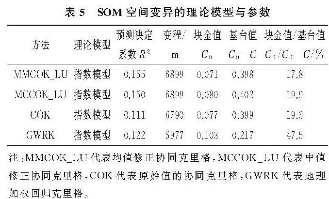
首先利用土地利用类型,GWR模型得到残差项,然后利用ArcGIS 10.2地统计模块建立训练子集209个,验证子集31个,最后利用ArcGIS 10.2地统计模块的协同克里格插值,插值过程中结合湟水流域DEM因子,拟合最优的半变异函数模型(表5)。本文4种方法均为指数模型。
结构、随机性变异是空间变异的两大模块,而C0,C0+C,C0/(C0+C)常常用来表示半变异函数建模的空间变异程度,其中C0为块金值,表示可能的随机性,这种随机因素可能为土地的耕作、施肥、管理措施等; C结构方差由自然因素,即地形、地质、土壤母质、土壤类型等引起的土壤性状的结构变异; C0+C为基台值,空间总的变异一般由基台值表示; C0/(C0+C)为块金与基台值之比,称为块金系数,其大小表示空间的变异程度,值小则表示空间变异程度大多是结构性因素引起的,反之值大则为随机性因素引起[2]。
研究区MMCOK_LU,MCCOK_LU,COK模型的块金系数分别为17.8%,19.9%,19.3%,属于强的空间相关性,GWRK的块金系数为47.5%,属于中等的空间相关性; 前3个模型表明土壤有机质空间变异主要由结构性因素引起,而最后一个模型表明土壤有机质空间变异主要由结构性和随机性因素引起,原因可能是在考虑土地利用类型后,空间细节信息更丰富,人为的影响更突出[C0/(C0+C)>75%:弱空间相关; C0/(C0+C)<25%:强空间相关; 之间属于中等空间相关]。变程表示变量在空间上的自相关性,MMCOK_LU和MCCOK_LU的变程均为6 899 m,COK为6 790 m,GWRK为5 977 m,表明在这个范围内空间自相关是存在的,均选择指数模型作为最佳模型。
2.3 模型精度分析
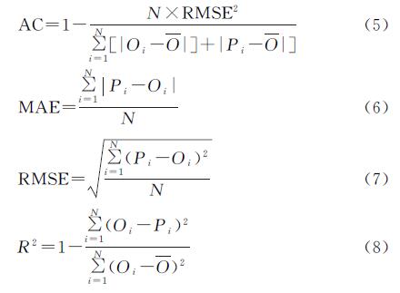
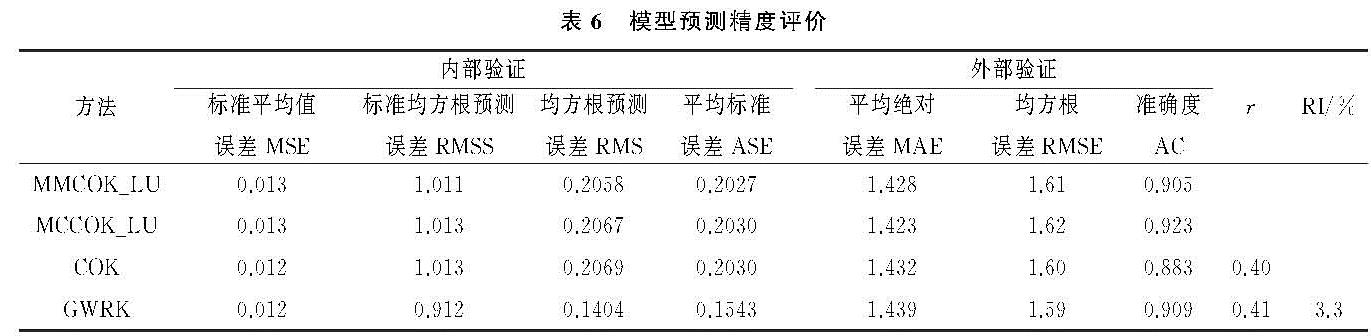
由表6可知RMSS标准均方根预测误差MMCOK_LU最接近于1,4种方法的MSE相差不大,COK,GWRK仅比MMCOK_LU与MCCOK_LU小0.001,COK的ASE与RMS接近程度为0.003 9,大于MMCOK_LU与MCCOK_LU; MAE平均绝对误差MCCOK _LU最小,GWRK最大,说明MCCOK _LU的模型精度最高,其次分别为MMCOK_ LU,COK; RMSE均方根误差GWRK最小,MCCOK_LU最大,说明GWRK比COK,MMCOK_LU,MCCOK_LU稳定性高; 而对于模型的准确度,由表6中的AC可知预测准确度由大到小依次为MCCOK_LU>GWRK>MMCOK_LU>COK; 与COK相比,GWRK相对提高3.3%。综上所述,可以发现结合土地利用中值残差的MCCOK_LU模型精度最高。
2.4 有机质空间插值及 结果与分析
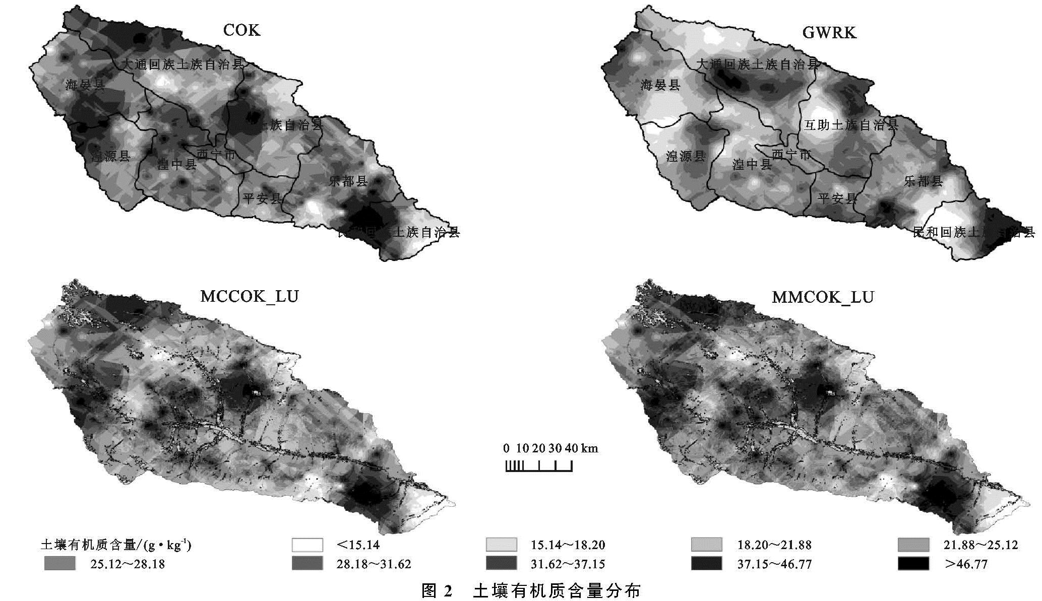
图2中可以看出4种方法的SOM预测值分布范围相差不大,COK(协同克里格)与GWRK(地理加权回归克里格)的土壤有机质空间分布较为连续,而MMCOK_LU(均值修正协同克里格)、MCCOK_LU(中值修正协同克里格)分布比较破碎,但是反应的地类细节特征以及信息的丰富程度较好; MCCOK_LU高值区相较于MMCOK_LU少,GWRK的低值区最少,四者的分布中间值最多。
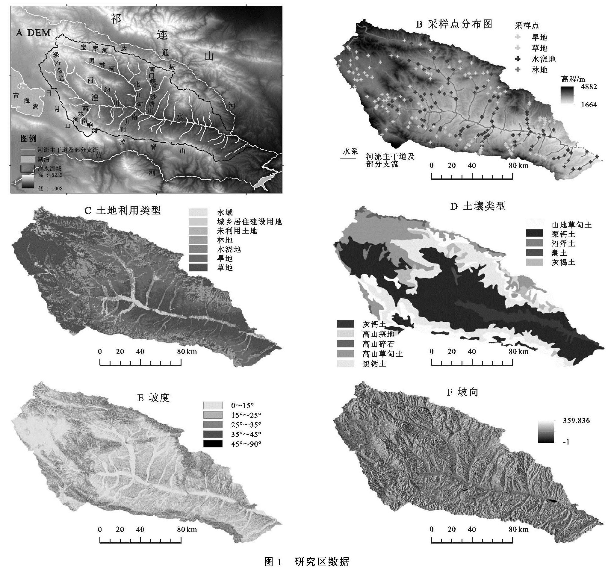
4种方法所产生的高值均分别集中在大通县西北部、海晏县南部和湟源县西北部等地区,互助县中西部以及湟中县北部也有零星高值出现; 其中大通县西北部、大通县与海晏县交界处的高值可以结合DEM图、土地利用图以及土壤类型图(图1)进行分析,该区海拔相对较高,薛晓娟等[21]的研究发现,海拔3 400 m以上土壤有机质含量开始急剧上升; 且该区受人为因素影响小,多为林地和草地(动植物残体腐烂分解为腐殖质),所以该地区主要为SOM丰富的地区,且该区主要发育高山草甸土,通过青海土壤[22]高山草甸土有机质含量在不同的区域差异较大但是普遍含量较高,这是因为高山草甸土的土壤形成过程慢,表层粗的有机质易于积累,所以有机质含量较高,该区土壤有机质含量大约在38.8 g/kg左右,预测结果与该值相符; 在海晏县南部地区和湟源县西北部地区、互助县西部、西纳川、石崖庄主要分布栗钙土,部分山地草甸土与高山草甸土,该区栗钙土的土壤有机质含量较高,分解微生物的能力较强[14],根据青海土壤[22]该区水热条件较好,土壤较为肥沃,土壤有机质在40~55 g/kg左右,预测结果在50 g/kg左右,两者大致相符,且土地利用类型主要是草地、林地、部分旱地和水浇地,草地、林地有机质含量丰富,而旱地作物生长周期比较短,施肥较多,所以SOM值会偏高; 民和县西部、西南部、乐都县东南部主要土地利用类型为耕地与草地,栗钙土分布广,根据代子俊[14]的研究,发现该区农作物产出率有所提高,离不开当地农民对农田的精细管理和施肥,所以增加了土壤有机质的含量,该区SOM含量大致在55 g/kg左右。有机质低值区主要出现在大通回族土族自治县西南部、民和县东南部、乐都县南部地区; 民和县东南部,海拔最低,坡度相对较大且处于流域下游,如果遇有雨水,则对土壤的冲刷能力较大,而该区的栗钙土热量有余,水分不足,水热矛盾突出,SOM含量低,不易积累,加之水土流失强[22],所以会呈现出较低值; 大通回族土族自治县西南部主要分布黑钙土与部分栗钙土,土地利用类型主要是坡旱地,海拔在2 500~3 000 m左右,土温较高,土壤的水分较适中,土地耕作后透气性加快,使SOM矿化加快,除此之外该地耕种时间长,耕层经常烧灰,土壤颜色变浅,表层的SOM含量有明显下降趋势[22],所以该地有机质含量不是很高; 其他地区有机质含量基本处于预测值中间水平,即27 g/kg左右。
水浇地区域有机质含量受水量的影响较大,丰水期水储量大时会加速土壤的分解,会产生更多的有机质,此时有机质比较丰富,但是研究区处于干旱半干旱区,降水变化大,水量不是很充足,且日照大蒸发快,所以水浇地的SOM含量随气候的不同而发生变化; 结合图2与图1C发现草地的有机质含量在大部分地区高于林地,通过文献[23]发现主要原因是该地温性草原分布广,由放牧等人为因素影响较大,动物粪便等都会对SOM产生影响。