2.1 DEM分辨率对HI的影响
地统计分析的工作中需要大量的样本作为基本支撑,在本节中,对应的样本条件就是选取不同分辨率的DEM,分辨率越高,则样本量越大。不同分辨率的DEM 也代表了其对地表描述的综合程度。本节主要分析不同分辨率尺度下HI的变化态势,探究HI值对分辨率的尺度依赖性,进一步确定适合研究区的DEM分辨率。
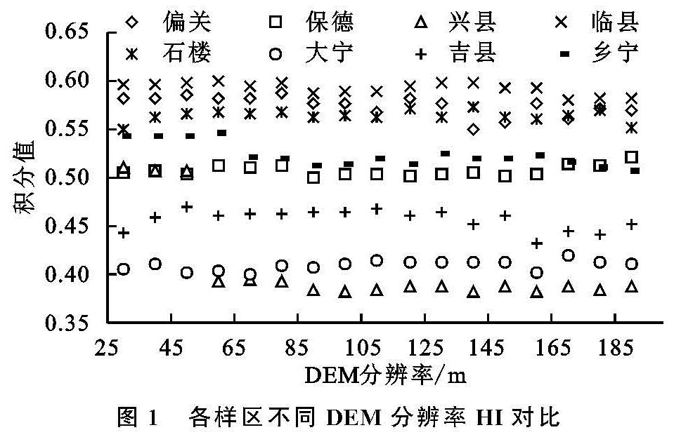
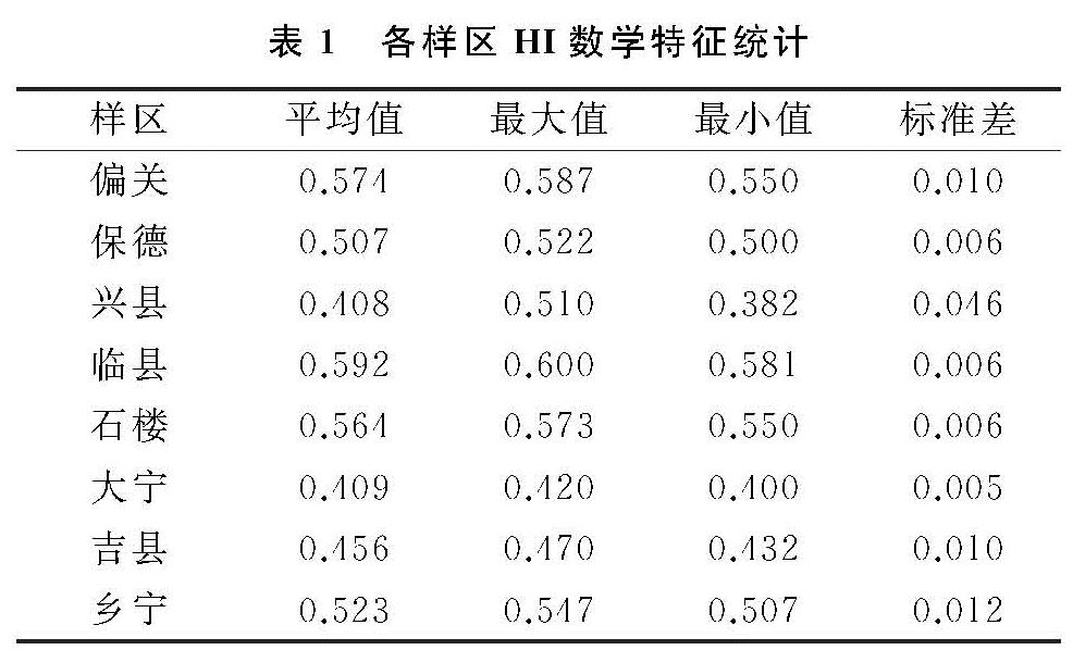
试验以30 m分辨率的SRTM数据为基础,以10 m作为采样间隔,重采样8个样区的DEM,得到30~190 m 的17幅DEM数据,分析HI对DEM分辨率的依赖性(图1)。各样区不同分辨率下HI值基本保持稳定,其中兴县的高程积分值出现上下0.1的浮动,在本文中与所选流域的面积大小变化有关。对比各分辨率尺度下HI的标准差(表1),兴县的标准差为0.046,偏关、吉县、乡宁约等于百分之一,保德、临县、石楼、大宁为千分之一。随DEM分辨率的逐渐增大,各样区HI值出现了小幅度的上下波动,但误差总体符合统计学的要求。在不同分辨率的尺度下,流域的高程积分值呈稳定态势,所以90 m分辨率的DEM可用于计算山西省黄土高原小流域的面积高程积分值。
对比8个样区的HI值,发现位于山西北部的偏关、保德、临县,以及南部的石楼、乡宁的高程积分值均在0.5以上,整体偏高,而位于中部的兴县、大宁、吉县的高程积分值较小,为0.4~0.45。根据Strahler对小流域地貌发育的分级,可知8个样区的流域地貌均处于壮年发育期,但山西中部黄土高原地区的流域地貌正由壮年期向老年期过渡。由面积高程积分计算方法体积比例法的原理[21]可得,由壮年期向老年期过度的期间,地表起伏变化程度较大,意味着流域会侵蚀更多的地表物质,因此会有山体滑坡等地质灾害发生的隐患,应在相应地区加强水土流失治理工作的力度。
2.2 流域面积对HI 的影响
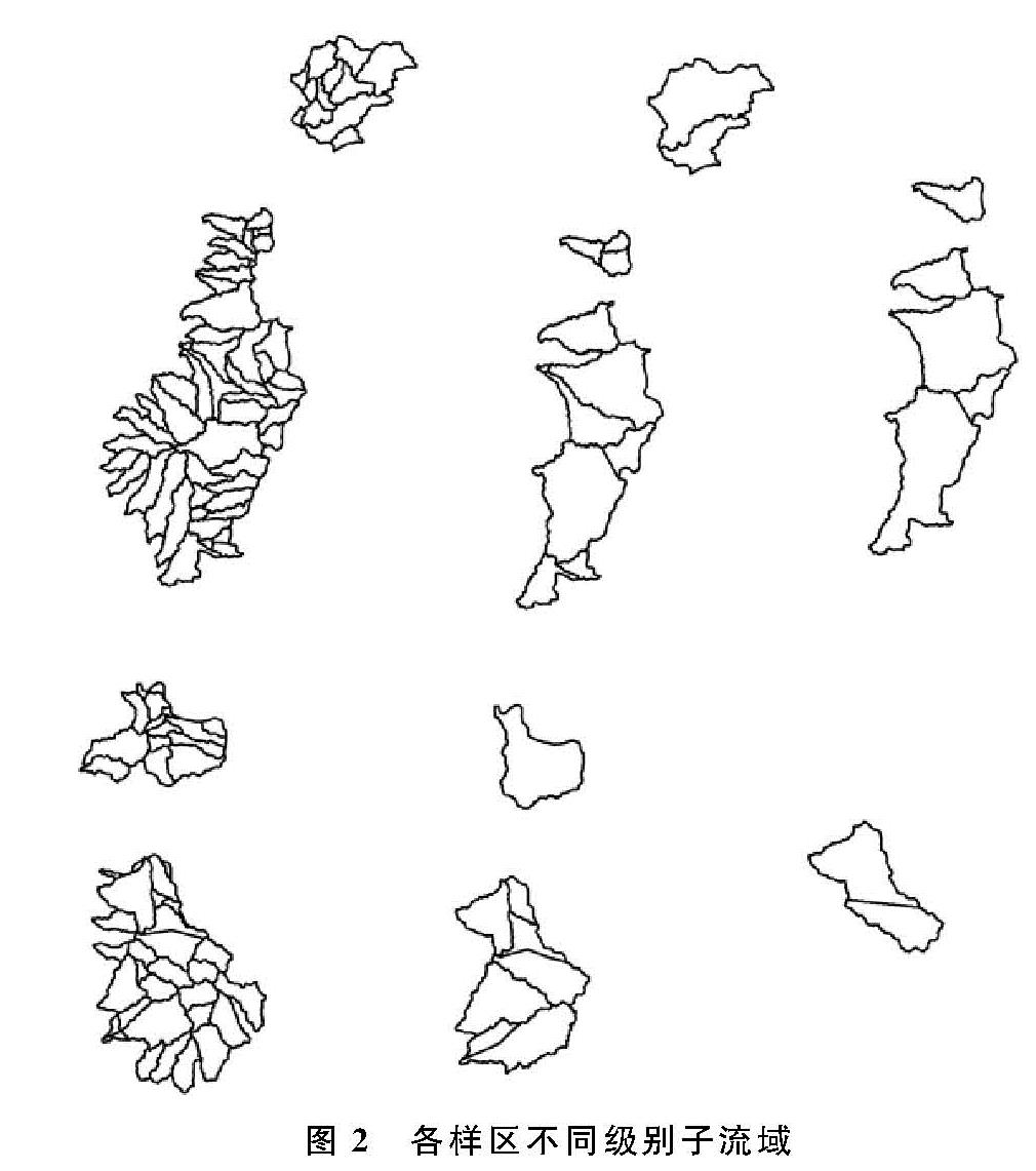
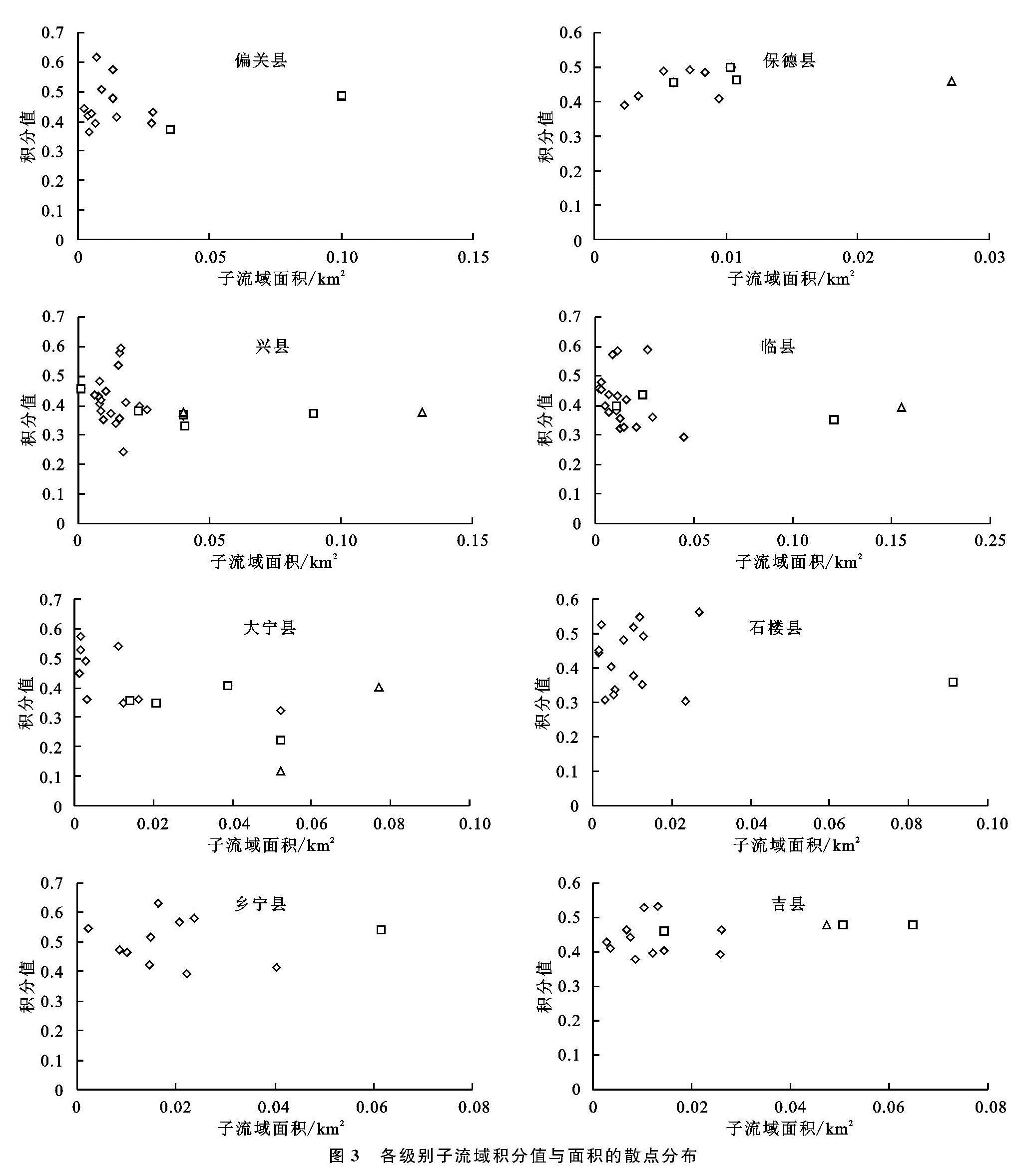
在提取流域的实际工作中,发现同一样区在不同分辨率下提取的流域面积并不固定,总体表现为分辨率越大,流域越破碎,相应地面积高程积分值也会变化。本节在区域尺度下,将样区小流域分割成若干子流域,根据Strahler流域分级法,将流域分为3个级别(图2),通过计算各级别子流域的面积高程积分值(图3),分析高程积分值对流域稳定面积的尺度依赖性,进一步确定研究区小流域面积高程积分的面积稳定阈值。
图2中一级子流域的数量远大于二级、三级子流域,且流域面积均小于二级、三级子流域面积,二级、三级子流域提取效果相差不大。其中乡宁县的子流域面积以及高程积分值分布较为松散,说明乡宁县的子流域面积较为不稳定,一级子流域的分布变化较为频繁,而这一现象正有可能是剧烈的水土流失以及流域侵蚀造成的,因此也增加了山体滑坡等地质灾害发生的几率。各样区一级子流域的高程积分值域分布范围较广,随着子流域面积的增大也即流域级别的上升,其积分值逐渐收敛,值域范围明显缩小。
综合上述试验结果,小于0.04 km2的小流域面积高程积分值分布范围广,差异较大。本文将0.04 km2作为研究区小流域面积高程积分的面积稳定阈值,在HI的空间分异分析中,面积小于0.04 km2的小流域将不参与计算。
2.3 流域内不同地貌对象HI的相关性分析
黄土高原区域内存在大量典型的地貌对象,如黄土峁梁、黄土峁、黄土梁、黄土残塬、黄土塬[22]等,每一种地貌对象对应的高程积分值均有所差异。由于不同地貌对象在空间上存在拓扑关联性,则其面积高程积分值必然存在一定的相关性[23]。地貌对象的面积高程积分特征有效补充了流域的面积高程积分特征,相关性的强弱程度有助于分析全区域地貌对象的空间分异特征。
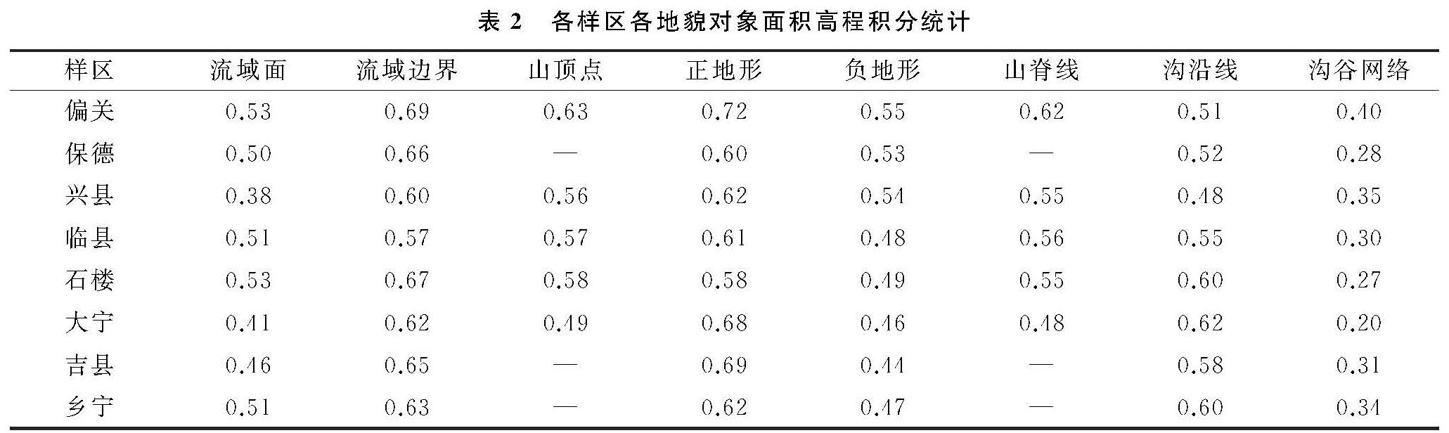
本节选择8个较为典型的黄土高原地貌对象,分别为流域面、流域边界、山顶点、正地形、负地形、山脊线、沟沿线以及沟谷网络,计算各样区内地貌对象的面积高程积分值(
表2)。其中除沟谷网络外,其余7个地貌对象的高程积分值均偏大,为0.5~0.7,沟谷网络的积分值在0.3附近。其中正地形与沟谷网络的积分值形成明显的对比,正地形最大积分值为0.72,沟谷网络最小积分值为0.20,明显的反差有力地说明了流域对地貌的侵蚀作用不可忽视,尤其在黄土高原区域,土质较为疏松,更易形成流域侵蚀,引发不同程度的地质灾害。
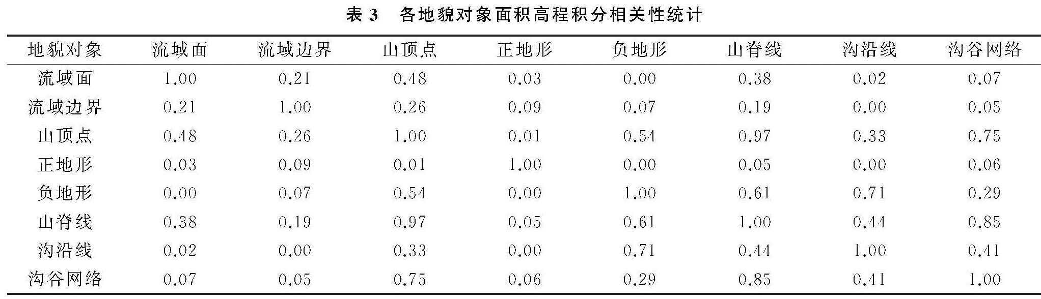
根据地貌对象面积高程积分的相关性分析(表3),表现出较强相关性的地貌对象组合有山顶点—山脊线,R2 为0.97; 山顶点—沟谷网络,R2为0.75; 负地形—沟沿线,R2为0.71; 山脊线—沟谷网络,R2为0.85。较弱相关性的有流域面—山顶点,R2 为0.48; 山顶点—负地形,R2为0.54; 负地形—山脊线,R2为0.61; 山脊线—沟沿线,R2为0.44。其余的都小于0.4,没有呈现明显的相关性,相关性较低的地貌对象有助于分析研究区面积高程积分值的空间分布格局。
2.4 面积高程积分空间分异
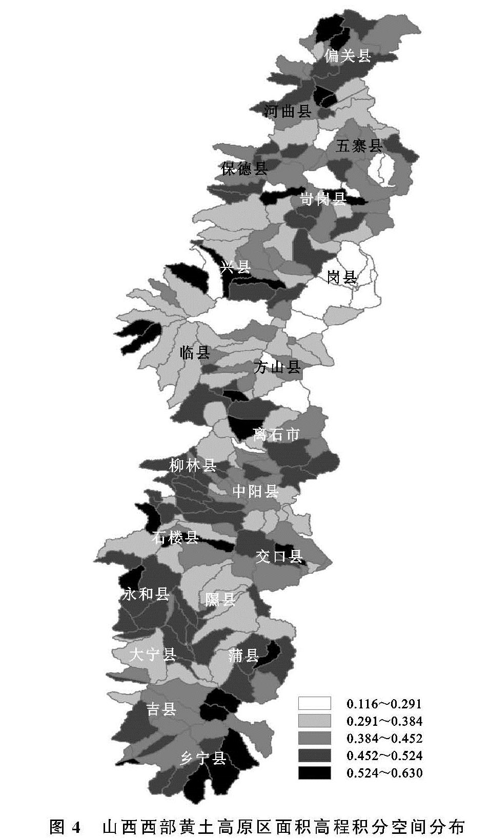
山西省黄土高原重点水土流失区位于山西省西部,本节选择的样区从山西省西北部偏关县到西南部乡宁县,共20个县级行政区,做山西省黄土高原重点水土流失区面积高程积分的空间分异研究。以90 m分辨率的SRTM数据为基础,利用ArcGIS中的水文分析模块提取一级子流域,根据阈值0.04 km2剔除不合理流域后,共得105条小流域,以流域为单元计算各个流域的高程积分值,绘制HI空间分布图(图4)。
山西省黄土高原重点水土流失区积分值的地域差异性从北到南,呈现由大变小再变大的空间分布趋势,其中HI峰值出现在北部。北部与南部的高程积分值基本处于0.45~0.63,中部的积分值为0.12~0.38,从面积高程积分与流域发育阶段的关系看,黄土高原区的北部和南部处于流域地貌发育的壮年期,中部部分地区处于流域发育的老年期。
8个样区的高程积分值空间分布情况为,偏关县共提取12条流域,其HI值均处于0.45~0.63,所以偏关县整体处于流域发育的壮年期,其县域境内北部与南部的高程积分值偏大,中部偏小; 保德县共提取到9条流域,流域基本都为东西走向,HI值处于0.38~0.52,虽然积分值均大于0.35,但积分峰值偏小,说明保德县流域发育正由壮年期向老年期转变; 兴县提取的流域最多,共20条一级子流域,其中17条流域的积分值处于0.38~0.45,东南部的3条流域HI值约等于0.56,这说明兴县境内85%的流域已经处于发育的老年期,流域侵蚀地貌程度较为严重; 临县提取到19条流域,县域内西部的流域均呈南北走向,东部的流域均为东西走向,其中位于北部与南部的3条流域积分值在0.55以上,中部6条流域的HI值均小于0.35,剩余10条流域的积分值处于0.35~0.45,说明山西省黄土高原区由北向南在临县内首次出现了处于发育老年期的流域,可从侧面说明流域侵蚀对临县的水土流失贡献率较大; 柳林县提取了14条流域,除北部的3条流域外,积分值均大于0.45,相比于北部临县的低积分值,黄土高原流域的积分值在柳林出现了回转,积分值开始升高; 南部大宁县共提取流域7条,其中1条流域在一、二、三级流域的提取当中,其范围均未改变,且纵跨大宁县,占大宁县总流域面积的53%,说明大宁县境内的流域面积较为稳定,流域发育较为缓慢; 吉县一级子流域共有11条,积分值均在0.5左右,积分值大小分布均匀,表明吉县境内子流域发育程度相当,且处于壮年期; 位于最南部的乡宁县共提取流域10条,基本都为南北走向,积分值均大于0.45,西北部的积分值偏小,东南部偏大,说明西北部的流域侵蚀地貌程度较大,2019年3月15日乡宁县发生的重大山体滑坡就位于西北部的枣岭乡。造成山体滑坡的原因复杂多样,介于黄土高原地质地貌的特殊性,流域侵蚀是造成山体滑坡等地质灾害的一项潜在因素,侵蚀程度越大,发生地质灾害的几率越大。