3.1 不同区域的DEM精度总体评价
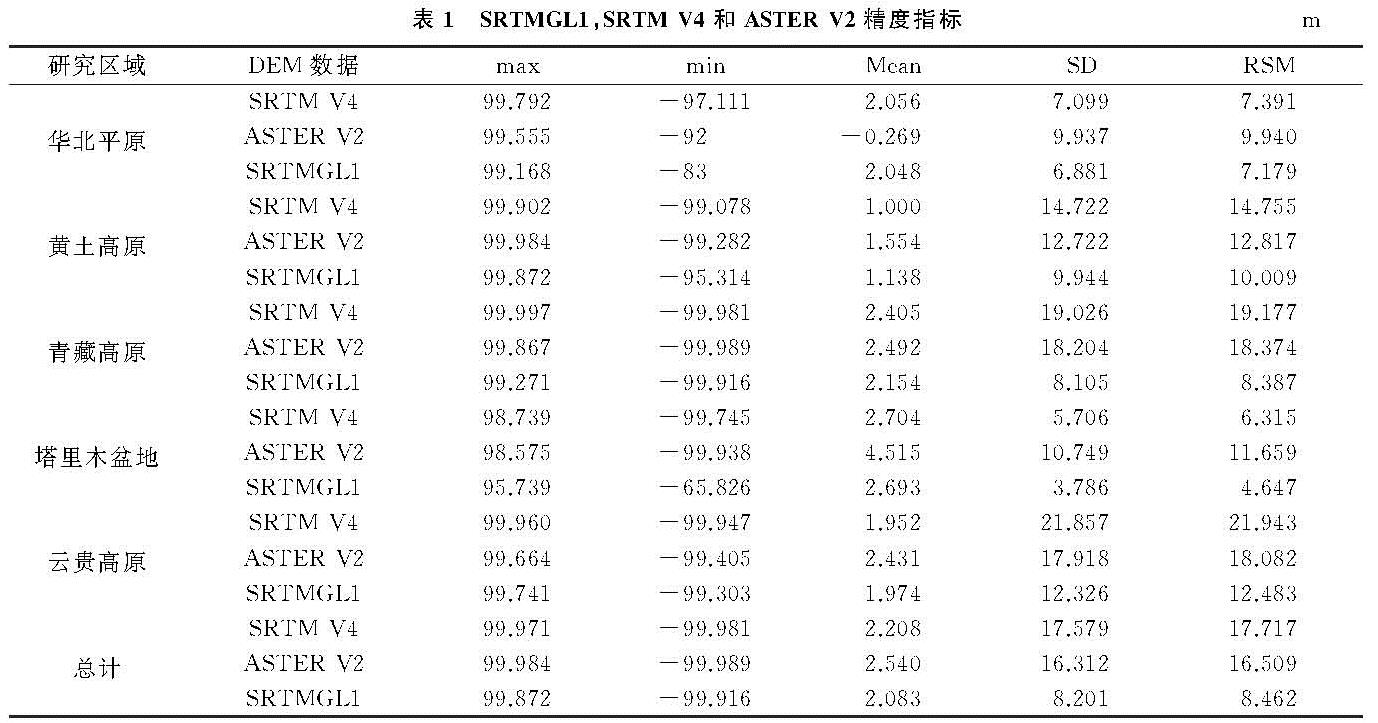
3种DEM在5类典型区域的精度评价结果见表1,结论如下:(1)总体上,SRTMGL1的数据精度明显优于SRTM V4和ASTER V2,SRTMGL1的平均误差为-2.083 m,系统误差为(2.083±8.201)m,数据精度为8.462 m,离散程度较另外2种DEM也偏小; ASTER V2总体精度则略微优于SRTM V4,ASTER V2平均精度为2.540 m,系统误差为(2.540±16.312)m,数据精度为16.509 m,SRTM V4平均精度为2.208 m,系统误差为(2.208±17.579)m,数据精度为17.717 m;(2)结合试验区,SRTMGL1在5类试验区中精度表现均为最优,数据精度保持在10 m左右,SRTM V4和ASTER V2则在不同的试验区精度表现各有优劣。华北平原和塔里木盆地两个试验区中,SRTM V4精度优于ASTER V2; 而在黄土高原,青藏高原和云贵高原3个试验区中,SRTM V4精度迅速下降,精度明显低于ASTER V2,分析其原因,极大程度是因为ASTER GDEM通过对立体影像对解译获得,其精度易受云或者地标建筑等影响,而SRTM V4受地形起伏或是植被覆盖度等影响,因此,在平坦区域,SRTM V4精度优于ASTER V2,当地形起伏较大,如山地地区,ASTER V2精度优于SRTM V4。(3)3种DEM随着试验区的不同,精度表现均有着不同程度的变化,华北平原和塔里木盆地,3种DEM均具有较好的精度,三者分异性不大,当试验区为高原地区,3种DEM则产生了较大差异,充分说明,3种DEM与地形有着密切的关系[14]。
表1 SRTMGL1,SRTM V4和ASTER V2精度指标m
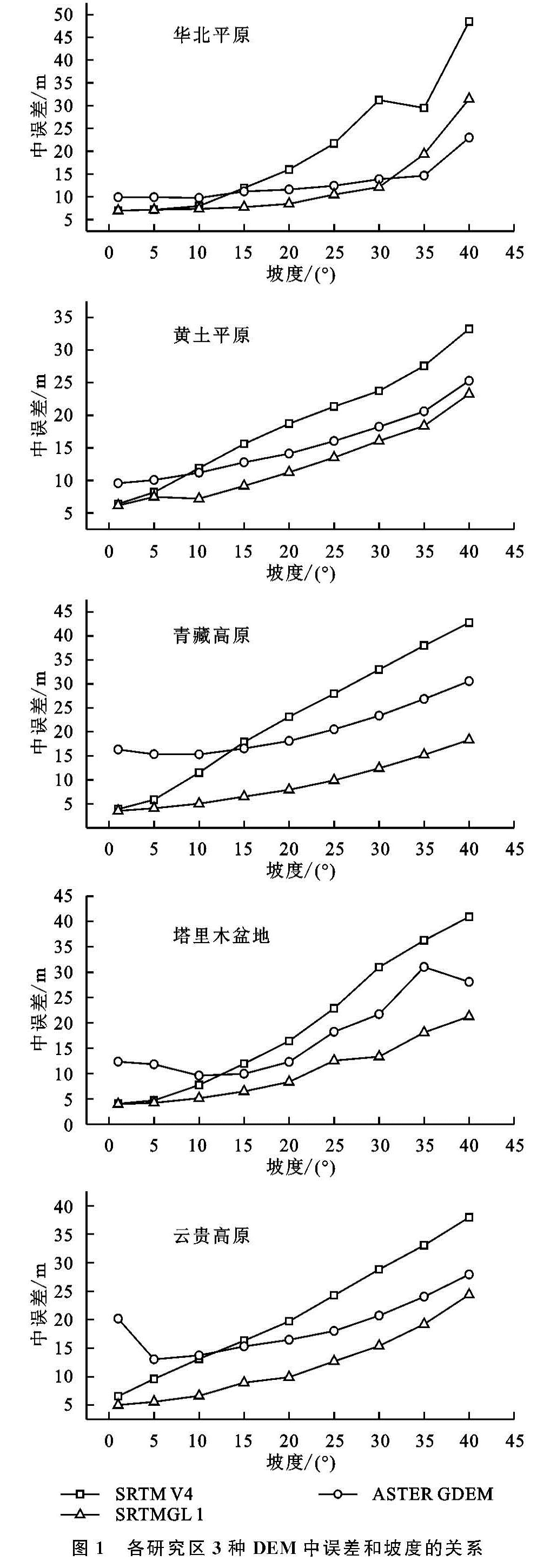
3.2 坡度对DEM精度影响
3种DEM中误差在不同研究区域随坡度分级的变化特征如图1所示,3种DEM在所有区域都保持着随着坡度的增加,中误差逐渐递增的趋势。在所有的研究区域中,SRTMGL1的数据精度都要优于SRTM V4,在地势较为平坦的地区(坡度<1°),SRTMGL1和SRTM V4中误差较为接近,其中,华北平原两种DEM中误差之差为0.02 m,塔里木盆地两种DEM中误差之差为0.05 m,黄土高原、青藏高原、云贵高原两类DEM中误差之差依次为0.25 m,0.4 m,1.5 m,精度差异细微,2类DEM可以互为补充,在此坡度分级下,由于成像方式的不同,ASTER V2与SRTM DEM存在着3~13 m的中误差之差,精度较差。随着研究区内坡度增大,不同研究区内3种DEM中误差变化规律逐渐不同,SRTMGL1和ASTER V2在各研究区内都保持着相对平稳的中误差之差,华北平原、黄土高原、青藏高原、塔里木盆地、云贵高原2类数据之差依次为(0.6±4.0)m,(2.8±0.6),(11.4±1.4)m,(7.6±3.8)m,(6.5±3.3)m。分析DEM在所有5个试验区中精度表现,SRTMGL1一般保持着最高精度,但是在华北平原地区,当坡度>30°时,SRTMGL1精度迅速下降,ASTER V2精度优于SRTMGL1,为3种数据精度最高。而SRTM V4和ASTER V2随着坡度分级,各有优劣:在坡度较小(<10°)时,SRTM V4精度优于ASTER V2,当坡度>10°,ASTER V2精度开始优于SRTM V4,且SRTM V4精度随着坡度的增加,分异程度明显大于ASTER V2,递增速率明显,精度较差,ASTER V2则与SRTMGL1保持着接近的递增速率,相对SRTM V4而言具有较高的精度[14]。
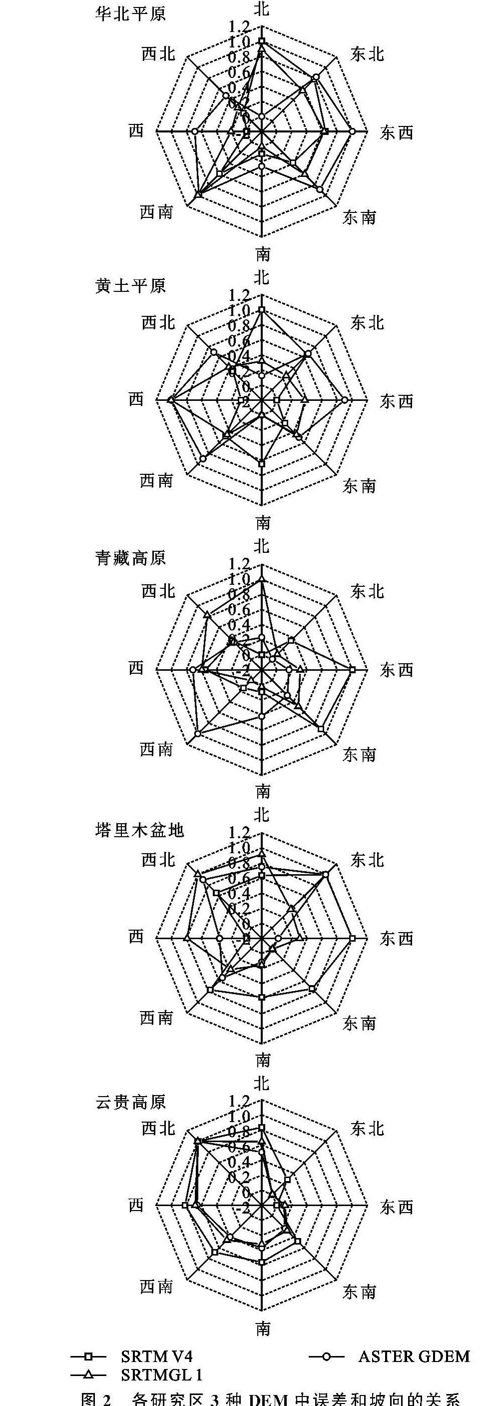
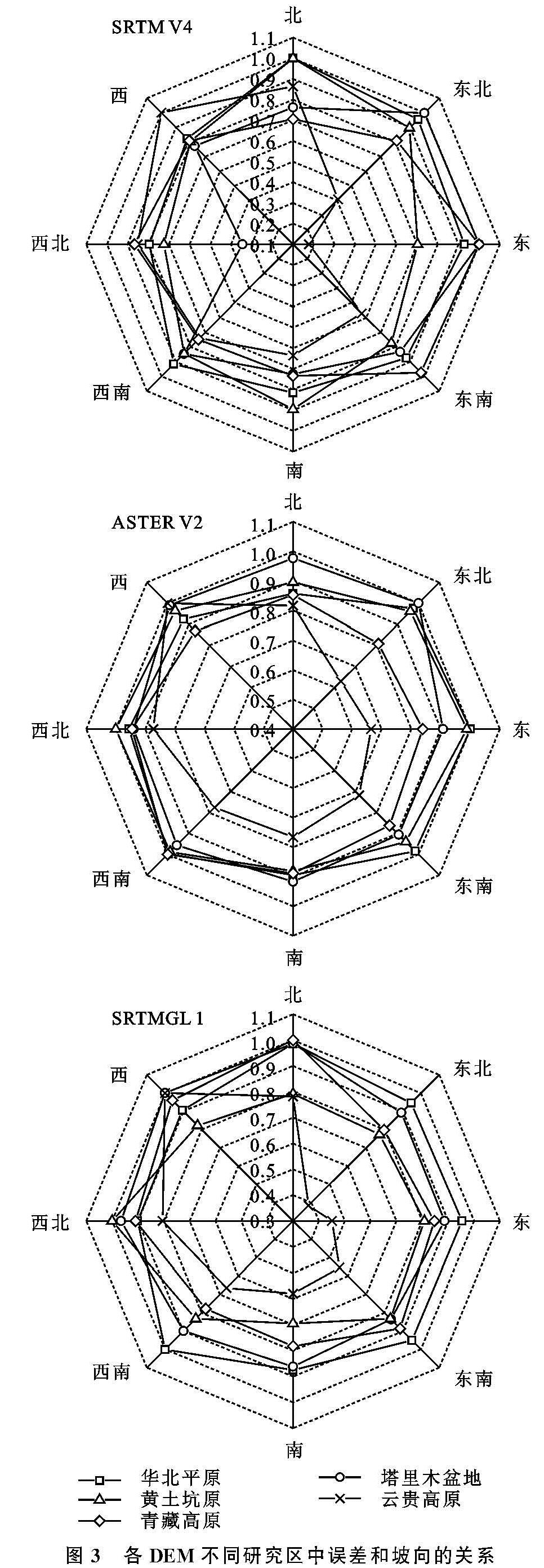
3.3 坡向对DEM精度影响
将坡向以45°为一个区间,划分为8个坡向级,北方向(337.5°~22.5°)、东北方向(22.5°~67.5°)、东方向(67.5°~112.5°)、东南方向(112.5°~157.5°)、南方向(157.5°~202.5°)、西南方向(202.5°~247.5°)、西方向(247.5°~292.5°)、西北方向(292.5°~337.5°),参考Zhang等[15]在研究地表覆盖对SRTM DEM精度的影响时控制变量的思想,为了研究3种DEM在不同区域的精度表现,将3种DEM在5类典型区域的各坡向中误差归一化到区间内,绘制在雷达图上,以研究3种DEM在不同区域的精度表现,结果如图2所示。其中,ASTER V2在5个区域的西南坡向上均出现了较大的中误差,SRTM V4的中误差主要出现在正西,正东,正北,正南方向。SRTMGL1则呈现不规律性。
在黄土高原研究区,3种DEM均呈现对称分布。而在地势平坦的华北平原地区,SRTM V4和SRTMGL1精度随坡向分异性大致相似,在地势复杂的云贵高原研究区,3种DEM精度分异性大体一致,分析其原因,可能是因为云贵高原的高密度植被覆盖导致DEM的精度均有所下降。在地势复杂而地表覆盖不高的青藏高原研究区,3种DEM分别呈现出截然不同的分异性,SRTM V4,ASTER V2和SRTMGL1分别在东南,西南,西北方向精度最低,并明显规律。随坡向的变化,3种DEM表现出高程测量偏离值分异特征,原因可能与卫星传感器在上升轨道和下降轨道的航向以及SRTM传感器雷达与地表的入射角度有关。
将每一种DEM在不同研究区的随坡向的精度表现绘制雷达图,结果如图3所示3种DEM在华北平原、塔里木盆地、黄土高原和青藏高原4个研究区中,随着坡向的变化,每一种DEM在4个研究区的精度变化程度大体相当,这表明在同一地区,坡向对DEM数据精度的影响不大。云贵高原则在东方向,东南方向以及东北方向出现了中误差变小的情况,而SRTMGL1和SRTM V4两种数据在5个研究区内误差分布相似,推测可能与SRTM传感器与地表入射角度有关。
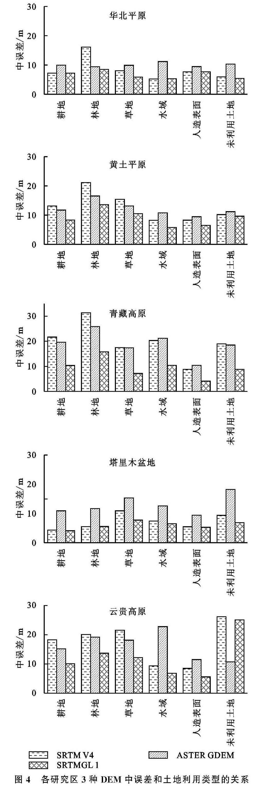
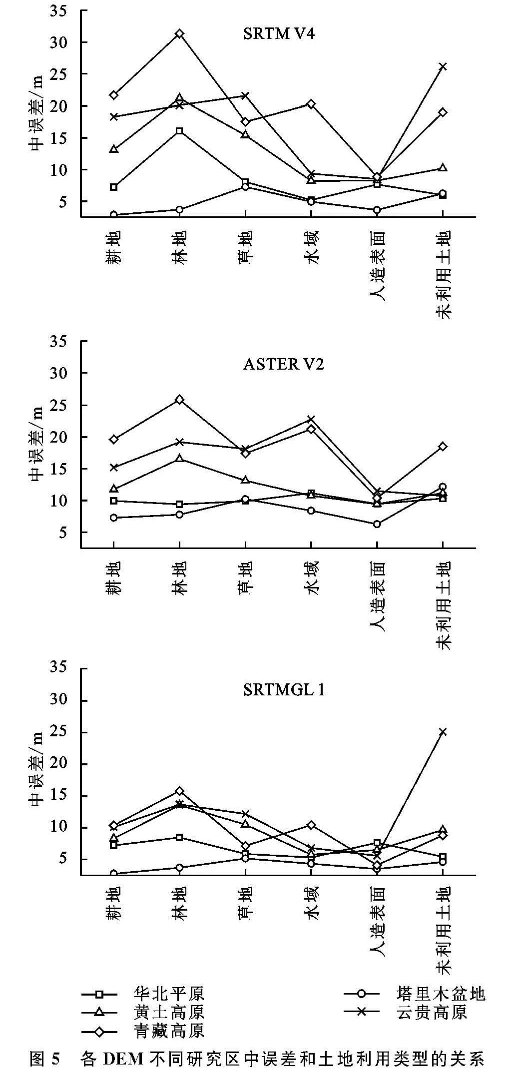
3.4 土地利用类型对DEM精度影响
基于土地类型对研究区域进行分类,将试验区分为耕地,林地,草地,水域,人造表面,未利用土地等5种类型。分别计算每个试验区各土地类型范围内的3种DEM与ICESat/GLAS控制点的中误差,进行统计,绘制柱状图(图4)以及将每种DEM的5个试验区随土地类型的变化进行纵向比较,制成折线图(图5)。
试验结果表明,同一试验区内,随着土地覆盖类型的变化,SRTMGL1精度均优于SRTM V4和ASTER V2。地势平坦地区(华北平原和塔里木盆地),SRTM V4和SRTMGL1两种DEM中误差之差较为接近,除林地类型以外,中误差之差最大值为2.2 m,最小值仅为0.01 m,充分说明平坦地区,不同的土地覆盖类型,SRTM V4与SRTMGL1数据精度相当,ASTER V2精度最低。而在高原地区,SRTM V4数据集精度略微低于ASTER V2,且在林地类型区域,SRTM V4数据偏差均高于ASTER V2,说明在高密度植被覆盖区域,ASTER V2的精度优于SRTM V4[16]。2种DEM虽然生成原理不同,但均受植被覆盖影响严重,因此林地的精度较低。
在对3种DEM的横向对比中可以发现,SRTM V4数据集随土地利用类型的精度变化,由高到低依次为:人造表面,耕地,未利用土地,水域,草地,林地。其中SRTMGL1与SRTM V4保持统一的精度变化趋势,但是SRTMGL1数据集整体精度高于SRTM V4。ASTER V2的精度随着土地利用覆盖类型的变化,中误差随着人造表面,未利用土地,水域,草地,耕地,林地而依次增大[17]。
图4 各研究区3种DEM中误差和土地利用类型的关系
图5 各DEM不同研究区中误差和土地利用类型的关系
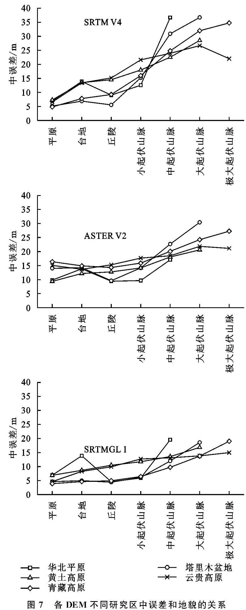
3.5 地貌类型对DEM精度影响
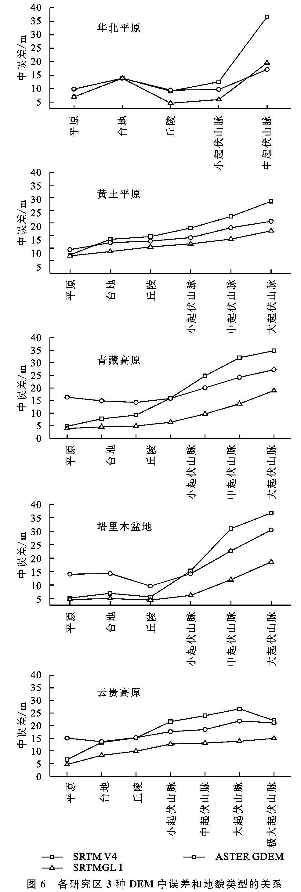
基于地貌类型对SRTMGL1,SRTM V4,ASTER V2进行分类,根据中国100万地貌类型空间分布数据集分类标准将地貌类型分为平原、台地、丘陵、小起伏山脉、中起伏山脉、大起伏山脉、极大起伏山脉,研究在5个试验区内,地貌类型的变化对于3种DEM的精度影响(图6和图7)。
结果表明,SRTMGL1在5个试验区均为精度最高的数据集,且ASTER V2在地貌类型为平原的地区精度是3种DEM中最低的。5个试验区中,华北平原、青藏高原、塔里木盆地、云贵高原4个试验区中SRTM V4在平原、台地、丘陵的精度均高于ASTER V2。当地貌类型变为山脉,且随着海拔的升高,ASTER V2精度高于SRTM V4。
总体而言,3种DEM均随着海拔的升高,中误差逐渐递增,其中,SRTM V4随着海拔的升高,中误差递增速率较快,在高原试验区的山脉地区中误差升高迅速,精度下降速度较快。SRTMGL1和ASTER V2中误差递增速率则呈现缓慢的递增趋势。3种DEM在5个试验区的台地地貌中精度明显下降,中误差明显高于平原和丘陵地貌,在华北平原试验区较为明显
[18]。