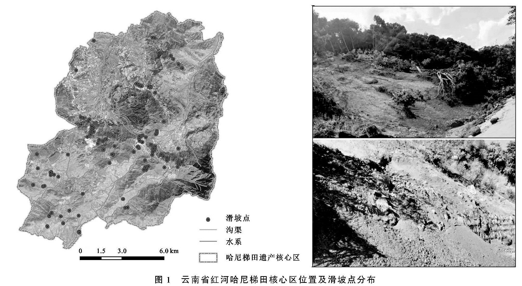
滑坡是我国乃至世界范围内发生最频繁、最具危险的地质灾害之一[1]。云南省地处板块交界处,构造运动强烈,地形陡峻,切割破碎,加之局地强降水频繁,滑坡、泥石流等灾害易发高发,是造成生命财产损失、制约区域经济发展的主要灾种。被列为联合国教科文组织世界遗产名录的哈尼梯田作为云南省旅游胜地,其地质环境脆弱,人类活动影响强烈,易引发滑坡等地质灾害。该区因受连续强降雨的影响,遗产地内老虎嘴梯田片区在2018年6月26日发生了一起重大的山体滑坡,造成约11.5 hm2梯田受损,严重威胁哈尼梯田世界遗产地景观的可持续发展。因此,开展世界遗产地滑坡易发性对区域的防灾减灾及可持续发展具有重要意义。
滑坡易发性评估始于20世纪70年代中期[2],以滑坡灾害理论、形成机制等定性描述为主。近年来,涌现出大量的定量评估方法,可归纳为两类:一是以滑坡灾害机制为基础“白箱”型方法,二是以灾害监测历史数据为基础“黑箱”型方法。“白箱”型方法主要包括斜坡力学[3]和专家经验模型[4]。斜坡力学模型侧重单个滑坡体,其可靠性较高,但所需水文、岩土力学等物理参数难以获得,进而难以大范围推广[5]。然而专家经验模型主观性较强,使得模型精度具有很大不确定性。“黑箱”型方法主要包括概率统计、机器学习模型等。概率统计模型评价方法在中国、印度、意大利和土耳其等地运用广泛,如逻辑回归[6]、频率比、判别分析[7]、数据叠加、证据权重[8]、信息量模型[9]等,虽然一定程度上减少模型主观性且表现性能相对较好,但仍然存在:高精度数据难以获得; 滑坡和地质环境资料需由专业学者初步处理; 权重受研究区间划分的影响[10]等缺点。相比之下,最近学术界更偏向于机器学习模型,它是一组强大的数据驱动工具,使用算法上考虑了滑坡与滑坡影响因子之间的非线性关系[11],有效克服了概率统计模型的局限性。如交叉决策树、随机森林[12]、贝叶斯[13]、支持向量模型[14]与人工神经网络[15]等应用广泛,但截至目前,依然缺乏最佳模型评价滑坡易发性。
为探究最佳模型以准确评价滑坡易发性,本文将最大熵模型(maxent entropy Model,简称maxEnt)引入到滑坡易发性评价中。maxEnt模型是由Phillips等[16]开发的生态位模型,作者将其应用物种生境适宜性评价。主要是根据物种的不完整分布数据和环境特征计算其分布概率,从而达到预测该物种潜在分布的目的。与其他模型相比,模型具有操作简便、计算效率高、预测结果精确性和可信度高,可避免模型过拟合等优势,因而被生态学者广泛应用,现已成为生态学研究的热点工具。物种分布模式与滑坡易发性制图非常相似,都是利用已知事件对目标空间分布进行建模,建模过程涉及多个环境变量。国外已有学者尝试将maxEnt模型应用于滑坡易发性的研究[17-19],但国内引用较为鲜见。
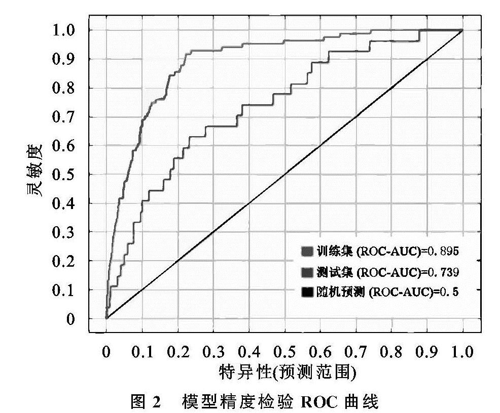
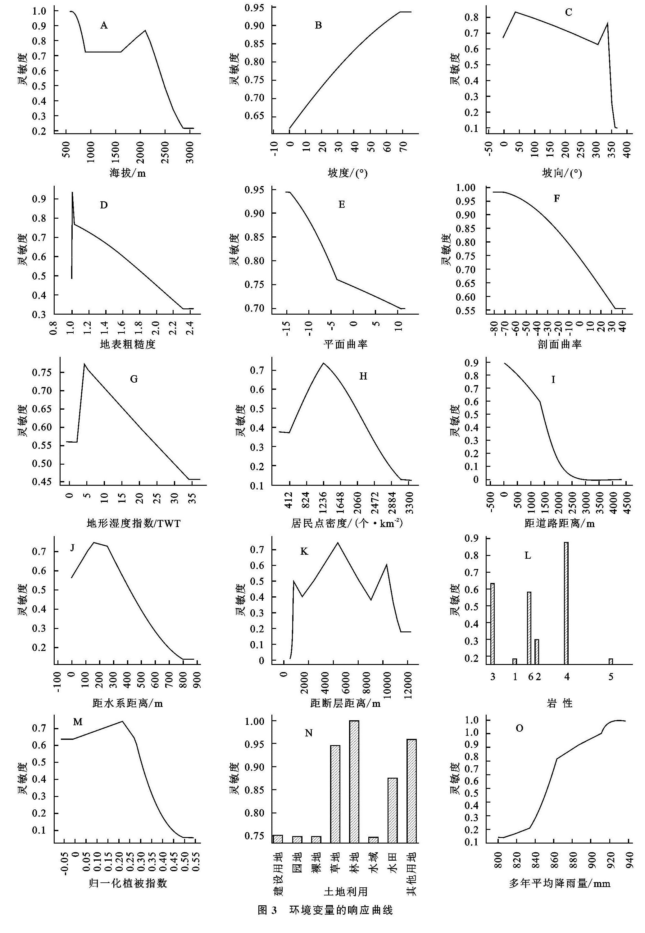
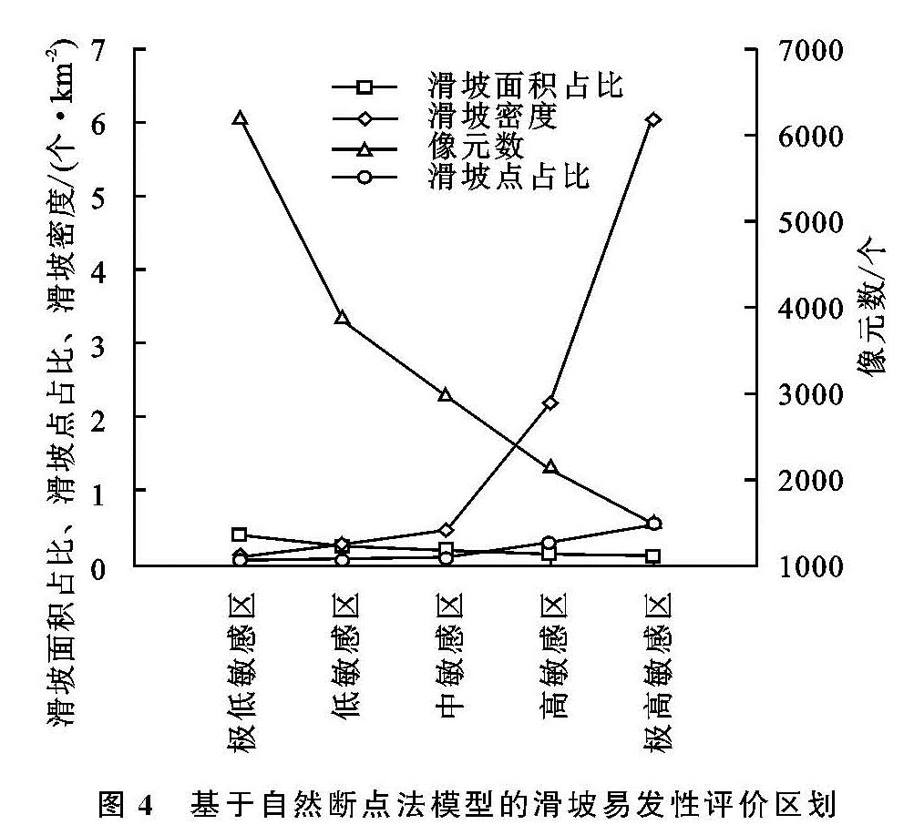
鉴于此,研究以哈尼梯田遗产地为例,综合研究区滑坡灾害发育的地质环境、滑坡空间分布和发育特征等数据,选取气象、地形、地质、植被、人类活动等15个指标因子,应用maxEnt模型进行滑坡易发性评估,通过计算历史滑坡点落在较高危险性区域内的比例和接收器工作曲线下的面积AUC值定量检验。探究maxEnt模型在哈尼梯田核心区滑坡易发性评价中的适用性,并对其预测性能进行评估。根据统计结果确定预测危险性等级评价标准,由此对预测结果进行危险性等级划分,这对哈尼梯田心区的可持续发展、土地利用规划及灾害防治有一定的参考价值。