2.1.1 多样化分析
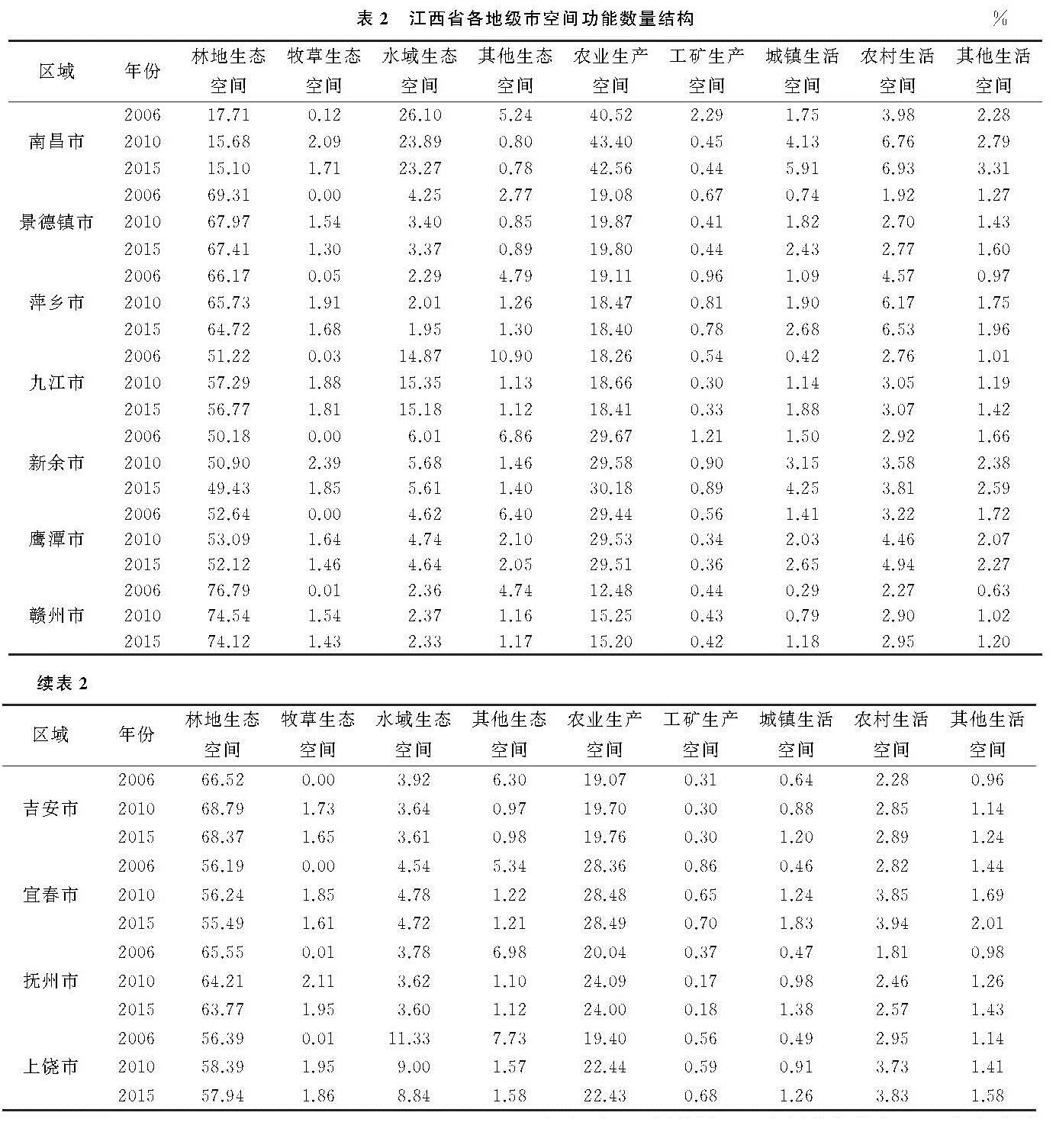
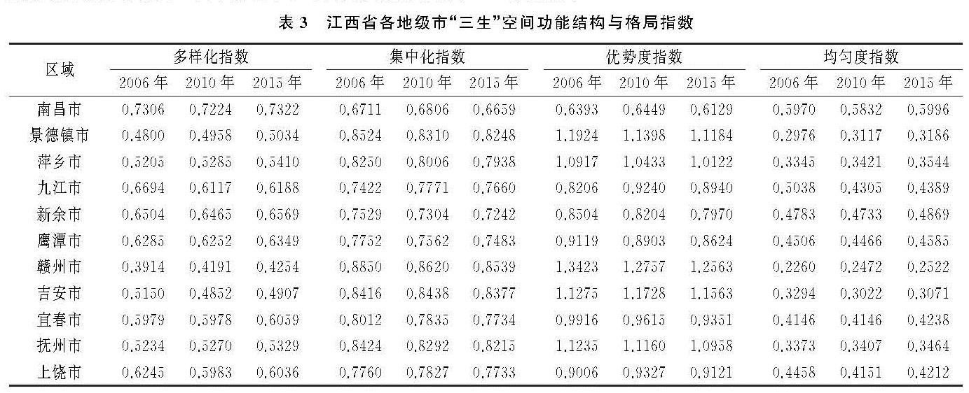
从市域角度看,江西省“三生”空间功能结构多样化分布格局呈现北部偏高,南侧偏低的递减格局(表3,图1A—C)。其中,将江西省“三生”空间多样化指数由高到低分为5级,南昌市多样化程度最高,大于0.7,说明“三生”空间功能类型齐全、比例结构协调,单一功能空间类型比例均在43%以下; 九江、新余、鹰潭、上饶4地多样化指数为2级,这4个城市个别空间功能类型比例超过58%; 宜春市的“三生”空间功能结构的多样化指数为3级,其中生态用地比例高达62%; 而位于江西省南侧的吉安、抚州、萍乡、景德镇4地多样化指数为4级,抚州和宜春两地的生态用地比例超过70%; 赣州市的“三生”空间多样化指数最低,说明“三生”空间功能比例结构不协调,空间分异显著。
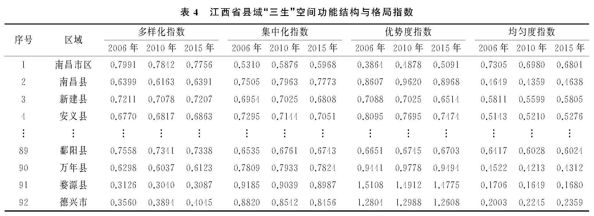
研究区县域“三生”空间多样化指数整体上呈现由北向南成不规则递减的分布特征(表4,图1D—F)。其中,高多样化指数的地区主要集中于永修、星子、鄱阳、都昌、湖口等县,约占高多样化县域空间的2/3; 低多样化指数县域单元共10个,其中赣州南部山区地区占4个,西南山区占3个; 而中多样化指数县域主要集中于赣中部地区。
根据图表中数据显示,2006—2015年,江西省“三生”空间功能结构多样化指数总体上呈增长趋势,其多样化分布格局呈现北部偏高,南侧偏低的特征,多样化指数空间分异显著。其中景德镇、萍乡、赣州、抚州地区呈现出持续上升型趋势,南昌、新余、鹰潭、吉安、上饶地区呈现出先减后增型趋势,而宜春多样化指数处于不变趋势,其中九江处于持续下降趋势。
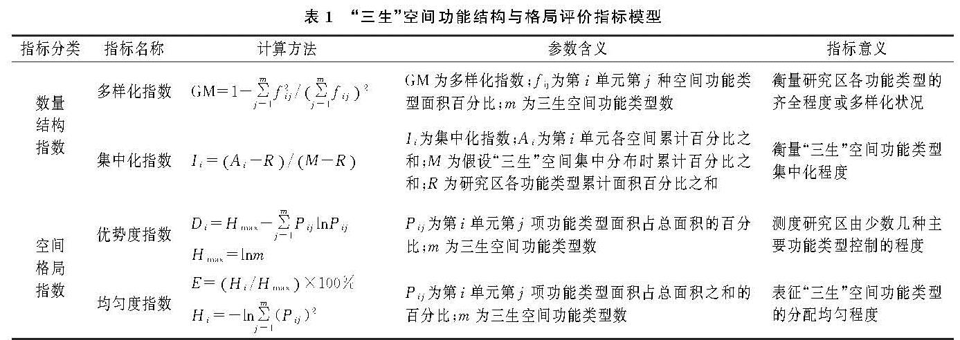
表3 江西省各地级市“三生”空间功能结构与格局指数
图1 2006年、2010年、2015年江西省多样化指数空间分布
2.1.2 集中化分析
由表3和图2A—C可知,江西省市域“三生”空间功能结构集中化指数较高,介于0.67~0.88,呈现出由南向北侧集中化程度逐渐降低的空间分布特征。根据数据显示,赣州、吉安、景德镇属于高集中化地区,抚州、宜春、萍乡三地市为中高集中化地区,而上饶、鹰潭为中等集中化地区,九江、新余为中低集中化地区,而多样化指数最高的南昌市则为集中化程度最低。
根据图表中数据显示,研究区县域“三生”空间集中度空间分布整体上呈现以四周高、中间低的空间分异特征(表4,图2D—F)。其中,赣东北部浮梁县、婺源县集中化指数高达0.9,赣南山区的大余县、崇义县、全南县、会昌县、寻乌县等集中化指数均为0.88。
利用集中化指数分析可知江西省“三生”空间集中化程度整体较高且空间分异显著,呈现出赣南、赣东北等四周高、赣中部低的空间分布特征。2006—2015年,江西省“三生”空间功能结构集中化指数分布整体上出现下降趋势。其中南昌地区和上饶地区呈现出先增后降型趋势,其他地级县市均出现下降趋势。
图2 2006年、2010年、2015年江西省集中化指数空间分布
2.2 “三生”空间功能空间结构分析
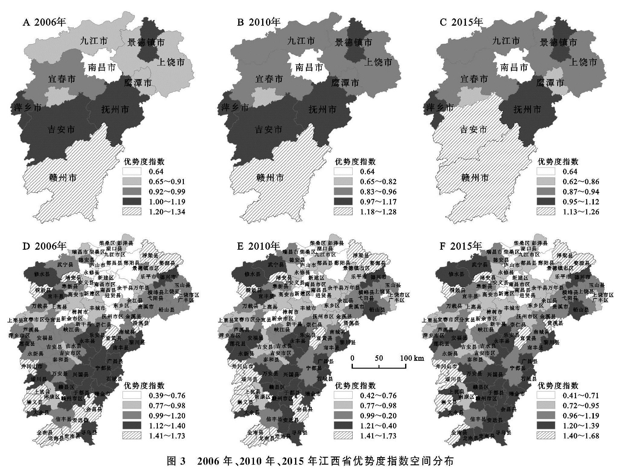
2.2.1 优势度分析
由表3和图3A—C可知,研究区市域优势度平均水平为0.9868,表明江西省三生空间功能结构整体优势度高,且空间分布呈现出南北两侧高、中间偏低的特征; 与研究区优势度平均水平相比,赣州、吉安、抚州、景德镇具有较高的优势度,而南昌和新余两地优势度最低,与平均水平相差较大,表明“三生”空间功能结构类型集中性较低。
从“三生”空间结构优势度指数看,研究区县域平均优势度水平为1.07,表明整体优势度明显,“三生”空间结构受一种或少数几种功能类型控制(表4,图3D—F)。各区县优势度指数距平均水平浮动区间达0.51,表明各区县“三生”空间结构差异较为显著。其中,赣东北部浮梁县、婺源县,西南部全南县、龙南县、崇义县等优势度指数最高。
根据数据显示,2006—2015年,江西省“三生”空间功能结构优势度指数分布整体上出现下降趋势,优势度水平较高且空间分异显著。其中景德镇、萍乡、新余、鹰潭、赣州、宜春、抚州地区呈现出下降趋势,其中下降最明显的分布在赣南山区。南昌、九江、吉安、上饶呈现出先增后降型趋势。
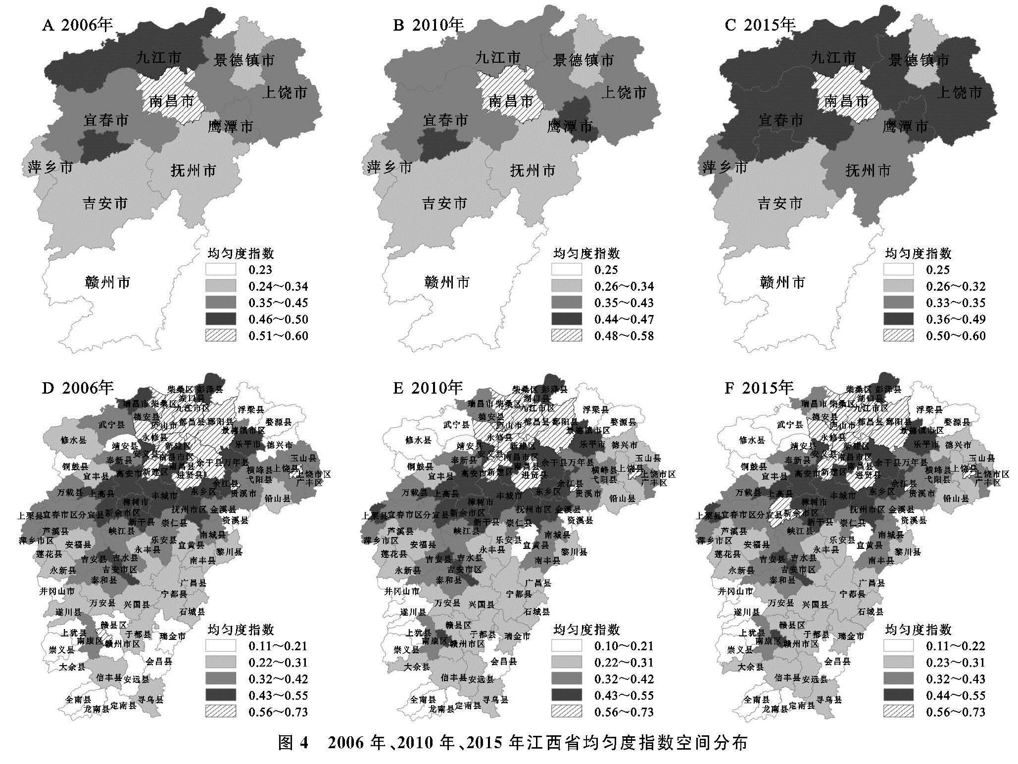
2.2.2 均匀度分析
由表3,图4A—C可知,研究区市域均匀度指数平均水平为0.397 9,表明江西省“三生”空间功能结构均匀度水平较低,与优势度呈现显著的负相关分布特征。具体来说,位于江西省南侧的赣州市均匀度指数最低,表明其“三生”空间功能结构类型均匀分配格局不明显; 而均匀度最高的南昌市则与之正好相反。
由表4,图4D—F可知,研究区县域均匀度指数平均水平约为0.37,表明整体均匀度不明显,且各区县存在一定差异,龙南、全南、会昌、大余、崇义、宜黄等县均匀度指数远低于研究区平均水平,表明“三生”功能结构空间均匀分配格局较低,而集中度较高。
根据图表显示,从2006—2015年,江西省“三生”空间功能结构均匀度指数分布整体上出现上升趋势,但江西省“三生”空间功能结构分异明显,均匀分配格局较低,集中性较高。其中景德镇、萍乡、赣州、宜春、抚州呈现出上升趋势,南昌、九江、新余、鹰潭、吉安、上饶呈现出先降后增趋势。
图3 2006年、2010年、2015年江西省优势度指数空间分布
图4 2006年、2010年、2015年江西省均匀度指数空间分布