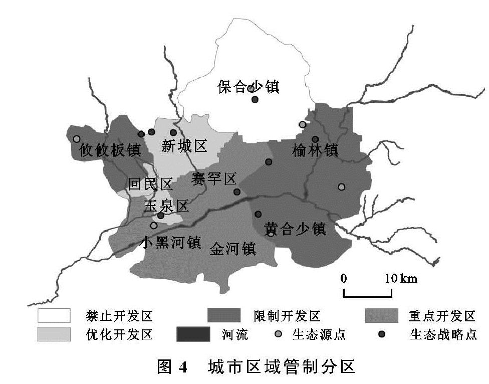
2.1 城市用地与生态用地扩张阻力评价指标体系的建立
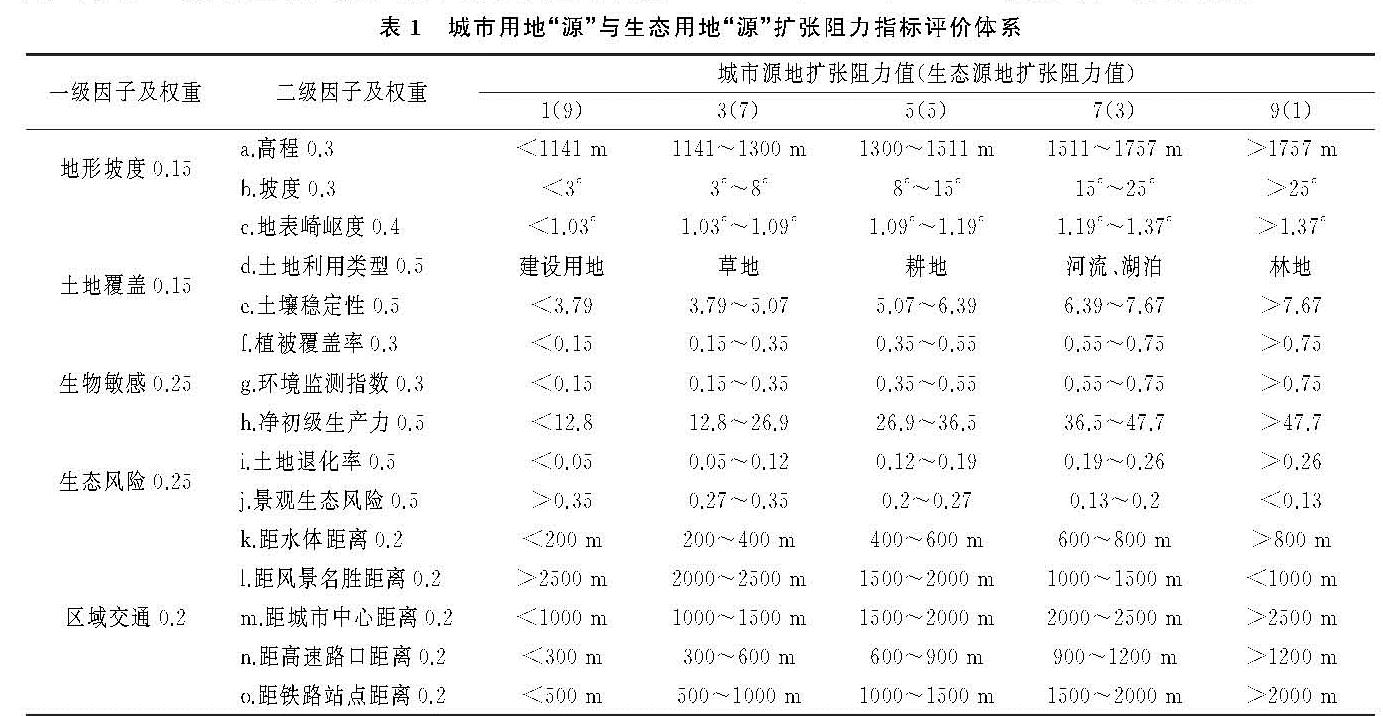
建立简明科学的用地扩张阻力评价指标体系对区域发展规划具有重要意义。鉴于研究区生态环境脆弱的实际,在城市发展过程中强调对生态、资源环境的保护也有利于推动区域人地关系和谐发展。考虑到城市环境的自然特征与人工特性,从研究区的自然环境、资源条件、人类干扰实际出发,选取地形坡度、土地覆盖、生物敏感性、生态风险性、区域交通5类影响因子构建城市用地“源”与生态用地“源”扩张阻力评价指标体系,包含二级阻力因子15个。选择面积大于5 km2的建设用地斑块作为城市用地扩张“源”,总面积为390.29 km2; 选择面积大于2 km2的林地和草地斑块[15]作为生态用地扩张“源”,总面积为479.35 km2。将阻力因子分为5级进行赋值,具体赋值从大到小依次为9,7,5,3,1。各因子权重的选择应用Delphi法进行赋值,具体评价指标及赋值情况见表1。对各阻力因子的解释如下:
(1)地形坡度。a.高程:海拔越高,生态环境越脆弱,就越不利于城市用地扩张。采用自然断裂法以1 141,1 300,1 511,1 757 m为界对城市用地扩张进行阻力赋值,生态用地扩张阻力赋值与之相反; b.坡度:坡度越高,越不利于建设用地扩张。根据《城市用地竖向规划规范》,采用自然断裂法以3°,8°,15°,25°为界对城市用地扩张进行阻力赋值,生态用地扩张阻力赋值与之相反; c.地表崎岖度:地表越粗糙,越不适宜开发建设活动。采用自然断裂法以1.03°,1.09°,1.19°,1.37°为界对城市用地扩张进行阻力赋值,生态用地扩张阻力赋值与之相反。(2)土地覆盖。d.土地利用类型:源地土地利用类型与当前土地利用类型越接近,就越利于源地用地扩张。根据土地利用类型对建设用地与生态用地扩张进行阻力赋值; e.土壤稳定性:土壤越稳定,就越有利于城市用地与生态用地扩张。建设用地与生态用地扩张阻力赋值一致。(3)生物敏感性。鉴于研究区位于干旱区与半干旱区的过渡地带,降水少而变率大,植被覆盖偏低。采用f.植被覆盖率(NDVI)、g.环境检测指数(GEMI)及h.净初级生产力(NPP)表征研究区植被的固碳释氧能力。植被分布越宽泛的地区越适宜生态用地扩张。采用自然断裂法对NDVI及GEMI以0.15,0.35,0.55,0.75为界,NPP以12.8,26.9,36.5,47.7为界向生态用地扩张进行阻力赋值,建设用地扩张阻力赋值与之相反。其中,NDVI=(NIR-R)/(NIR+R); GEMI=η(1~0.25η)-(R-0.125)/(1-R)。其中,NIR,R分别为Landsat遥感影像中的近红、红波段,η=[2(NIR2-R2)+1.5NIR+0.5R]/(NIR+R+0.5)。(4)生态风险性。i.土地退化率:土地退化越严重,就越不适宜各类用地扩张。建设用地扩张阻力赋值与生态用地阻力赋值一致。j.景观生态风险:采用景观干扰度表征研究区的景观生态风险程度。将景观生态风险指数赋予1.5 km×1.5 km格网单元后进行克里金插值。结果表明城市景观生态风险的高值主要集中在城市建设用地边缘地带,景观生态风险值越高,越说明该地带是城市用地扩张的潜力区域。采用自然断裂法以0.35,0.27,0.2,0.13为界对城市用地扩张进行阻力赋值,生态用地扩张阻力赋值与之相反。(5)区域交通。城市用地扩展多沿交通线进行定向推进,具有重要交通意义的地带往往具有很高的经济性。城市交通的发展对城市结构的内部调整也具有战略性意义。本文对研究区的k.水体、l.风景名胜区、m.城市中心、n.高速路口、o.铁路站点等矢量数据进行缓冲区分析。其中,水体以200,400,600,800 m做缓冲区对其赋值; 风景名胜区以2 500,2 000,1 500,1 000 m做缓冲区对其赋值; 城市中心以1 000,1 500,2 000,2 500 m做缓冲区对其赋值; 高速路口以300,600,900,1 200 m做缓冲区对其赋值; 铁路站点以500,1 000,1 500,2 000 m做缓冲区对其赋值。
表1 城市用地“源”与生态用地“源”扩张阻力指标评价体系
2.2 最小累积阻力面模型(MCR)的构建
最小累积阻力面模型(minimal Cumulative Resistance,MCR)由荷兰学者Knappen提出,最初始于对物种扩散的研究。近年来国内学者将其广泛应用于城市地理学、景观生态学等领域,其实质是各“源”地经过不同阻力景观所耗费的费用或克服阻力所做的功[16]。采用俞孔坚修正的MCR模型计算得到城市用地扩张阻力面和生态用地扩张阻力面[17]。其中,MCR模型的计算方式如下:
MCR=fmin(∑i=mj=nDij×Ri)(1)
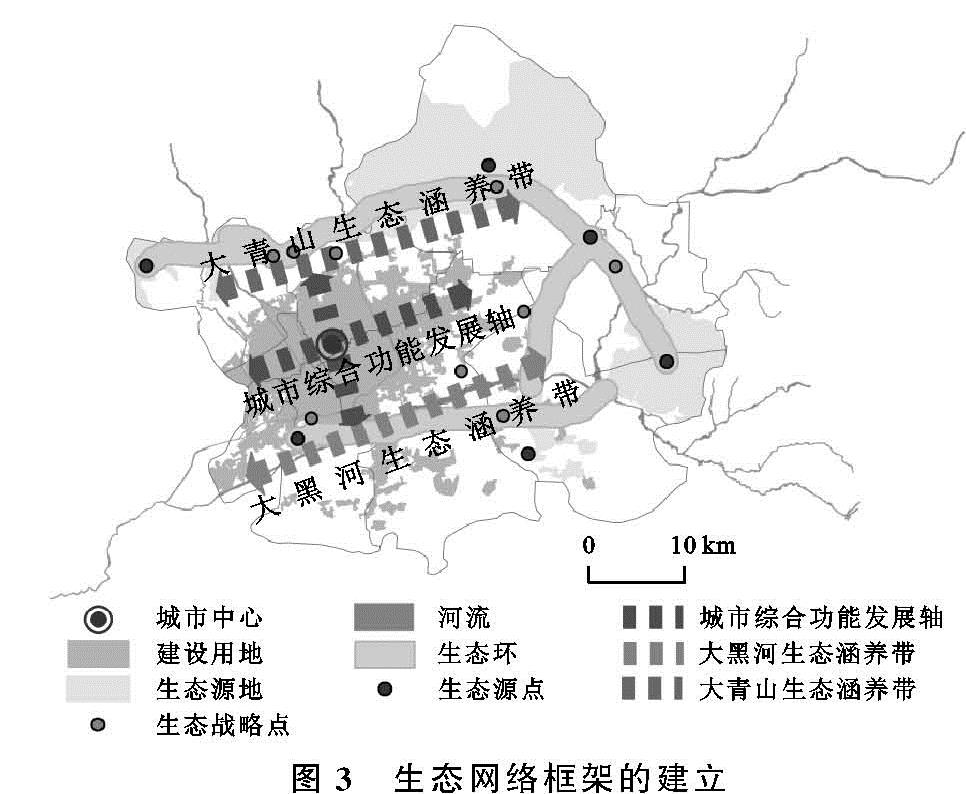
式中:MCR表示源扩展到某景观处的最小累积阻力值; f是个未知的负函数; Dij表示源i到景观j的空间距离; Ri表示源i在扩展过程中所受到的阻力值大小。本文将生态用地扩张阻力面与建设用地扩张阻力面进行空间叠加,从而构建研究区生态安全格局。具体计算方式为:MCR生态安全=MCR生态用地扩张-MCR建设用地扩张,将二者的差值作为生态安全格局的建立依据。当MCR=0时,是适宜生态用地与建设用地扩张的分界线; 当MCR>0时,适宜城市用地扩张; 当MCR<0时,适宜生态用地扩张。
2.3 生态廊道的识别
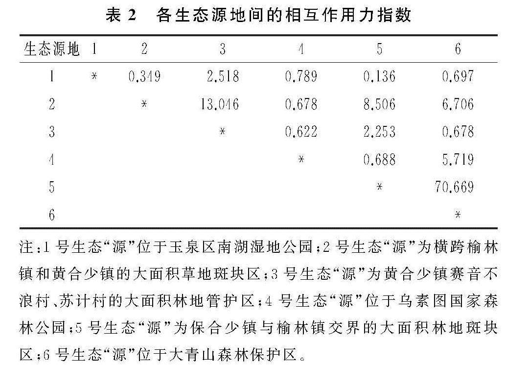
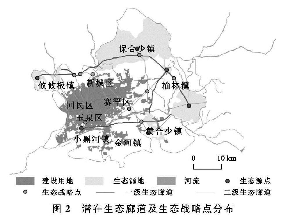
生态廊道是区域生态安全格局的重要组成部分,作为区域生态系统能量流动与物质循环的重要载体,对于改善区域生境质量、完善生态系统功能、加强生物多样性保护具有重要意义。识别重要生态廊道是维护区域生态要素流动的有效手段,构建区域生态安全网络利于增强生态系统功能的完整性。以生态源地的几何中心点作为生态源点,从每个源点出发,运用成本路径模块构建迭代模型提取源点(n)到剩余n-1个中心点的最小阻力路径,即潜在生态廊道。大型斑块和较宽的廊道生境适宜性比较髙,物种迁移的阻力较小,能大大增加物种在迁移过程中的存活率和成功率[18]。而潜在廊道的重要性可以用源地斑块间的相互作用强度加以判别。本文基于重力模型(Gravity Method)相互作用原理,定量评价斑块之间相互作用力的强弱,引入相互作用力指数判别重要廊道,对潜在生态廊道进行分级[6,19]。具体计算方式如下:
Gab=(ψaψb)/(θ2ab)=((1/(Ra)×lnSa)(1/(Rb)×lnSb))/(((Lsb)/(Lmax))2)=(L2maxlnSalnSb)/(L2abRaRb)(2)
式中:Gab是斑块a与b的相互作用指数; φa是斑块a的权重值; Ra是斑块a的阻力值; Sa是斑块a的面积; Lab是斑块a与b之间廊道的累积阻力值; Lmax是所有廊道累积阻力最大值。