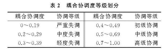
根据2007—2016年长三角城市群城市韧性与城镇化水平的统计数据,利用熵值法模型、耦合度和协调度模型,计算出长三角城市群26个城市的耦合度C与协调度D,从时间演变特征和空间分布特征两方面对长三角城市群的耦合协调度进行分析,并利用空间自相关模型对耦合协调度的空间分布类型进行划分。为便于分析,参考杨艳[26]、童纪新[27]等的研究,将耦合协调度划分为6个等级(表2)。
3.1 时间演变特征
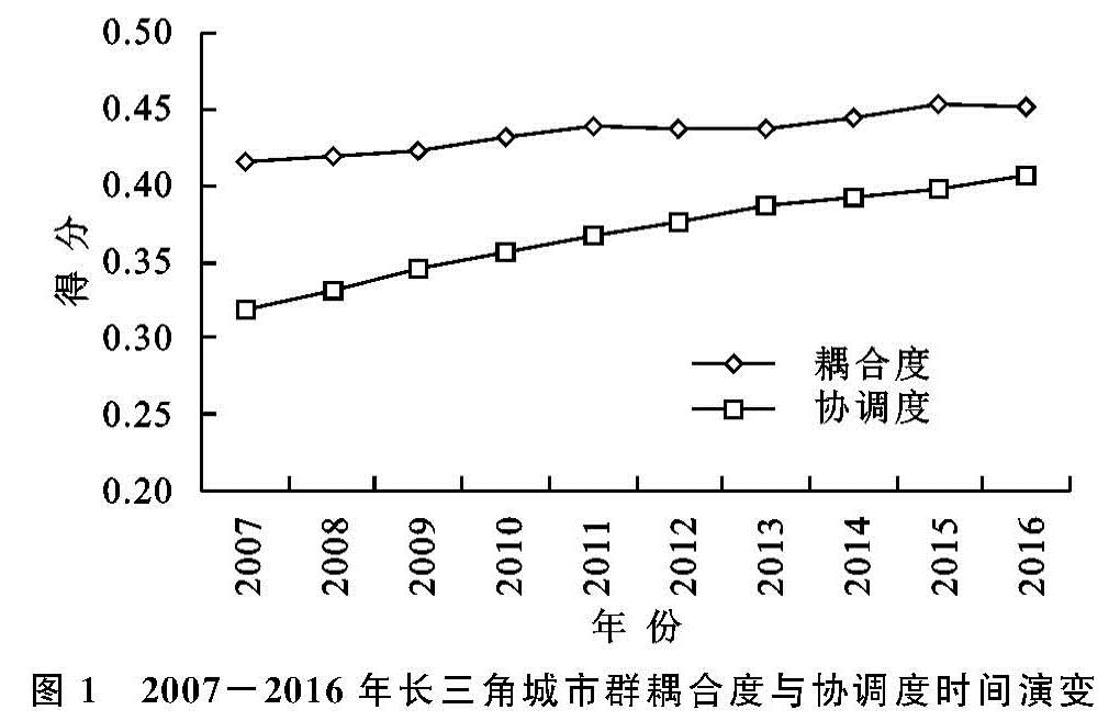
图1给出了2007—2016年长三角城市群整体耦合度与协调度的变化趋势。整体来看,2007—2016年长三角城市群耦合度和协调度均呈现上升趋势,且协调度水平低于耦合度水平,但二者之间差距逐渐缩短,这说明城市韧性与城镇化水平的相互作用有所增强。从耦合度变化趋势来看,长三角城市群的耦合度从2007年的0.415上升至2016年的0.452,增速较为明显,是推动长三角城市群协调度得以上升的关键因素。这表明城市韧性与城镇化水平差距缩小,二者综合评价水平更为接近。这可能由于城镇化进程的推进提升了城市软硬件系统的质量,从而为城市韧性的增强创造出诸多红利。从协调度变化趋势来看,2007—2016年长三角城市群的协调度增速明显,且在2016年初次步入初级协调水平,城市韧性与城镇化水平之间的关系处于相对稳定状态。主要原因在于,近年来国家对城市安全建设的重视及建设高质量城市政策的陆续出台,给城市创新安全治理水平提供了契机。一方面,长三角城市群积极进行产业结构的转型,将传统制造业与重工业向欠发展地区转移,大力发展现代服务业与高新技术产业,以高效率的创新产业带领城镇化进程走向更高水平。另一方面,政府积极创新社会治理模式,城市摒弃原有不合理、碎片化的管理方式,不断加大基础设施建设和城市风险的治理力度,此外,政府设计科学合理的城市规划布局,从全方面、多领域提高韧性系统建设和城镇发展质量,从而促进了城市韧性与城镇化水平的不断协同进步。
3.2 空间分布特征
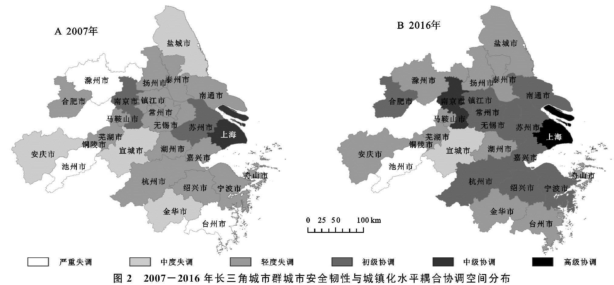
为进一步探究2007—2016年长三角城市群城市安全韧性与城镇化水平的耦合协调度空间变化,利用ArcGIS 10.2软件绘制出2007年、2016年的长三角城市群耦合协调度空间图(图2)。
图1 2007-2016年长三角城市群耦合度与协调度时间演变
由
图2A可知,2007年长三角城市群多数城市处于失调状态,协调城市呈“三点”分布(上海—苏州—南京),耦合协调度空间分布差异明显。具体来看,长三角城市群仅有3个城市处于协调状态,占城市总量的11.5%,其中上海市为中级协调城市,南京、苏州为初级协调城市,其余23个城市均处于失调状态。轻度失调城市主要包括扬州、镇江、马鞍山等16个地区; 中度失调城市以盐城、安庆、宣城、金华4个城市为代表; 滁州、池州和台州3地处于严重失调状态。此阶段,协调城市数量稀少,失调城市基数过大,导致长三角地区的耦合协调度整体不高,究其原因,2007年我国城镇化处于快速发展阶段,城镇化带来的社会变迁和宏、微观环境变动对城市运行系统造成巨大压力,使城市韧性建设与城镇化水平存在较大差异,因而导致二者耦合协调关系较差。
图2 2007-2016年长三角城市群城市安全韧性与城镇化水平耦合协调空间分布
从图2B可以看出,2016年长三角城市群耦合协调度提升明显,协调城市呈“Z”形分布,逐渐形成以上海为拐点,合肥、南京、苏州、杭州等协调城市相互连接的空间分布状态,地区之间的耦合协调差异明显缩减。具体来看,2016年初级协调及以上城市增至11个,相比2007年增长2.67倍,占城市总量的42.31%。其中,上海首次达到高级协调状态,综合得分0.708,是长三角城市群唯一的高级协调城市。这表明,上海的城市韧性建设步伐与城镇化水平发展一致性较高,二者关系发展十分调和。近年来,上海在城市空间规划、人居环境建设、城市运行与管理体制以及综合防灾减灾系统等方面均有重大改善。此外,产业结构调整、优化产业能级、创新产业发展等措施不断提升上海中心城市的引领带头作用,使得城市安全建设与高质量城镇化发展协同推进。南京从2007年的初级协调跃至中级协调水平,合肥、无锡、常州、镇江、绍兴、南通、嘉兴、宁波8市由轻度失调提升至初级协调。近年来,为适应新型城镇化规划的要求,南京、苏州、杭州等地将全面提高城市质量作为重点之一,因势利导、趋利避害,不断对城市风险与短板查漏补缺,积极引导城市走向健康化、韧性化的发展方向。此外,失调城市由2007年的23个跌至2016年的15个,失调城市总量缩减53.3%。盐城、安庆和金华从严重失调转变为轻度失调城市,滁州和台州变化明显,摆脱严重失调状态成为轻度失调城市。池州和宣城的失调状态依旧没有改变。这可能是由于两市的城镇化水平较低,城市发展难以摆脱经济增长的桎梏,无法兼顾对社会环境和公共风险的治理所致。
整体来看,2007—2016年,长三角城市群耦合协调度水平整体提升,协调城市数量明显增加,失调城市基数显著缩减,呈“东高西低、中部高边缘低”的差异分布格局,即以上海为核心,以省会城市为副中心,耦合协调度由东至西、从中心城市向边缘城市有所减弱。无论是2007年还是2016年,东部城市的耦合协调度高于西部城市,中心城市的耦合协调度高于边缘城市。如,紧邻东部的无锡、常州、嘉兴等协调度变化较为显著,城市协调水平整体较高,而处于西部边缘的多数城市协调度并不乐观,其中池州、滁州等市处于连年失调状态。作为区域战略核心,上海对周边城市具有极强的经济辐射作用,苏浙两省凭借紧邻上海的优越位置,积极发展高新技术产业和现代服务业,不断调整产业结构并积极向上海靠拢,成为上海发展的重要依托。与江浙沪地区的城市相比,池州、滁州等市的第一产业比重高、工业基础差、重点项目少、特色产业缺乏,资源利用率低,对城市安全管理建设重视度不高,城市治理投资力度小,使得城市安全韧性与城镇化水平关系陷入拮据发展、协调困难的局面。
3.3 空间自相关分析
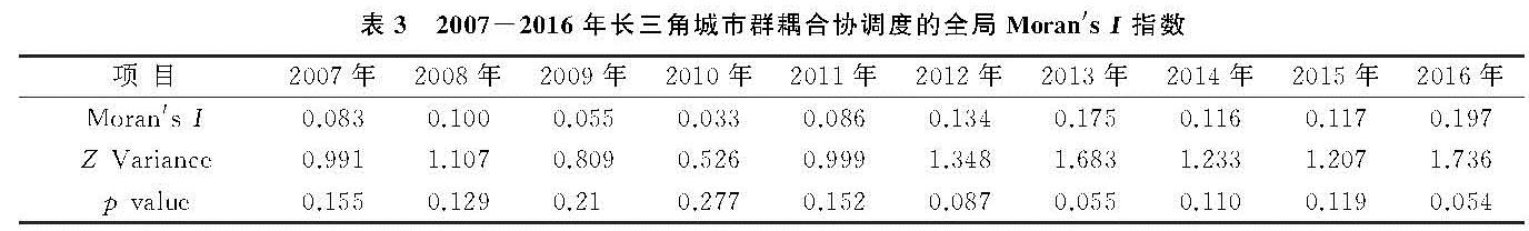
为进一步探究长三角城市群城市韧性与城镇化水平的空间集聚特征,利用GeoDa软件计算Queen权重矩阵下全局Moran's I指数值(表3)。
表3 2007-2016年长三角城市群耦合协调度的全局Moran's I指数
结果显示:2007—2016年长三角城市群耦合协调度的莫兰指数均为正值,取值范围为0.055~0.197。其中,2012年、2013年和2016年的Moran's I指数值分别为0.134,0.175,0.197,均通过90%的显著性水平检验。这表明长三角城市群耦合协调分布具有明显的正向相关关系,在空间分布上存在集聚效应,既协调地区与协调地区相邻,失调地区与失调地区相邻。其余未通过检验的年份,其空间正向相关关系不显著,耦合协调度趋向于随机分布。从整个研究期来看,Moran's I指数存在整体增长趋势,这表明耦合协调度的空间集聚效应增强,且在研究期末达到最强。
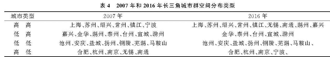
全局Moran's I指数表明长三角城市群的耦合协调分布存在空间集聚性,故引入局部自相关模型进一步探究耦合协调度的空间分布类型,根据2007年和2016年的Moran散点图(舟山市因无空间相邻地区而被剔除)将长三角城市群划分为4个不同的空间集聚类型,分别为高—高类型区、低—高类型区、低—低类型区、高—低类型区(表4)。
表4 2007年和2016年长三角城市群空间分布类型
(1)高—高类型区,表示城市安全韧性与城镇化水平处于良好发展状态,即一个城市与它周边城市为高耦合协调集聚。2007年该类型主要有上海、苏州、绍兴、常州、镇江、宁波6个城市; 2016年增至9个,其中宁波退出高—高类型,新增无锡、南通、湖州、嘉兴。此类城市往往具有较高的城市韧性与城镇化发展水平,且二者关系较为调和。
(2)低—高类型区,即一个低耦合协调城市相邻城市为高耦合协调。2007年该类型城市以嘉兴、金华、湖州、泰州、台州、宣城、滁州6市为代表,2016年嘉兴退出低—高类型区,其余5个城市未发生变动。此类城市发展难以受到周围高耦合协调城市辐射影响,这可能与自身发展模式有关。
(3)低—低类型区,表明一个城市与周边城市为低耦合协调聚集。2007年和2016年低—低类型城市未发生变动,均为池州、安庆、盐城、扬州、铜陵、芜湖、马鞍山7个城市。此类城市的韧性水平和城镇化水平相对较低,二者处于拮据发展的状态,需从韧性水平与城镇化水平两方面同时加以提升。
(4)高—低类型区,表示一个高耦合协调城市,它的相邻城市为低耦合协调。2007年此类城市代表为合肥、杭州、南京、无锡、南通5个地区,到2016年无锡和南通退出高—低类型区,新增宁波,其余城市未发生变动。此类城市往往拥有较高的城镇化水平,但却忽略了城镇化进程对城市安全的负面影响。未来应将城市韧性理念纳入城镇化发展模式之中,积极改变粗放型的城镇化发展模式,从而协调城市韧性与城镇化发展关系。