2.1 全国气温、降水量年际变化趋势分析
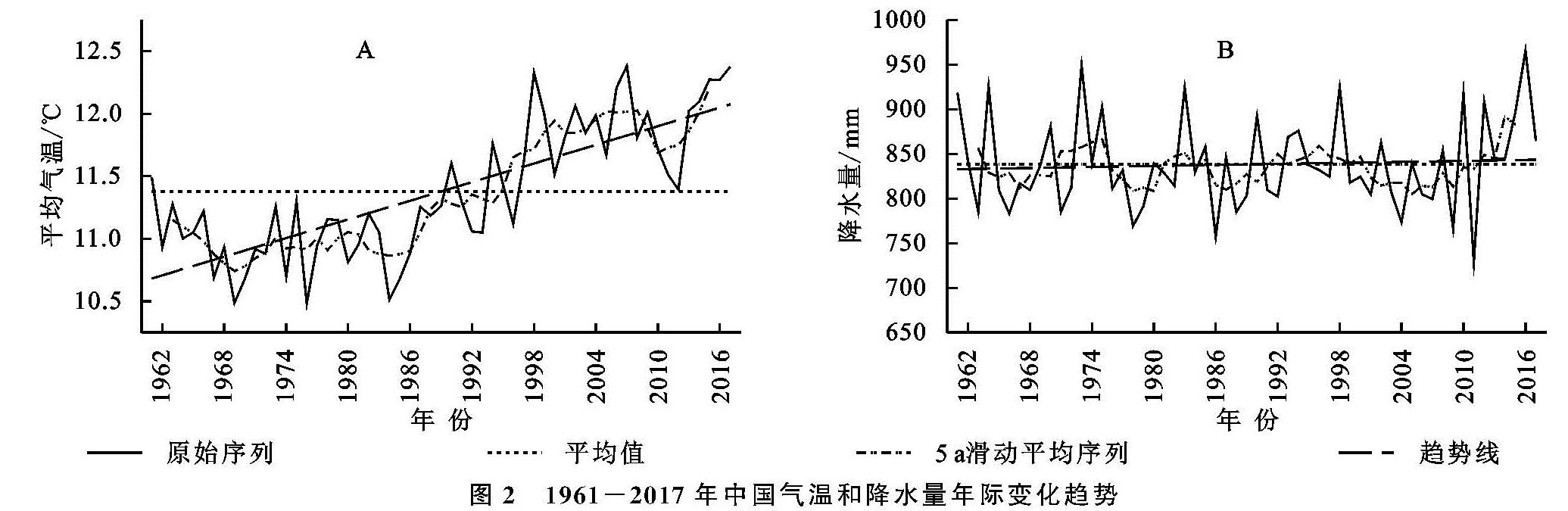
由图2A可见,1961—2017年中国区域气温年均值为11.38℃,呈上升趋势,变化倾向率为0.249℃/10 a,显著性检验表明在研究时段内中国气候显著变暖。图2B表明年降水量序列存在阶段性波动,多年平均值为838.20 mm,变化倾向率为1.89 mm/10 a,降水序列呈增加趋势,但未通过显著性检验。5 a滑动平均序列表明年降水量在1995年后出现持续近10 a之久的衰减期,但近10 a有明显增势。
图2 1961-2017年中国气温和降水量年际变化趋势
研究区1961—2017年年均气温、累积降水量时间序列M-K检验结果见图3。给定显著性水平α=0.05,则统计量UF和UB的临界值为±1.96。由图3A可知,对于全国年均气温时间序列,UF,UB统计量在置信区间内相交于1996年,表明年均气温变化在1996年存在一个突变点。结合UF统计量与显著性检验区域的位置关系分析,突变前年均气温历经1989年前的不显著下降(-1.96<UF<0)和1989年后的不显著上升(0<UF<1.96)两个阶段,突变后表现为显著上升趋势(UF>1.96)。同理,1961—2017年全国年降水量时间序列变化趋势于2015年发生突变(图3B),突变前年降水量以不显著下降为主(-1.96<UF<0),伴随阶段性不显著上升(0<UF<1.96),突变后序列呈不显著上升趋势(0<UF<1.96)。对比可见,M-K检验所得年均气温、年降水量变化趋势与图2一致。
图3 1961-2017年中国气温和降水量变化的M-K检验
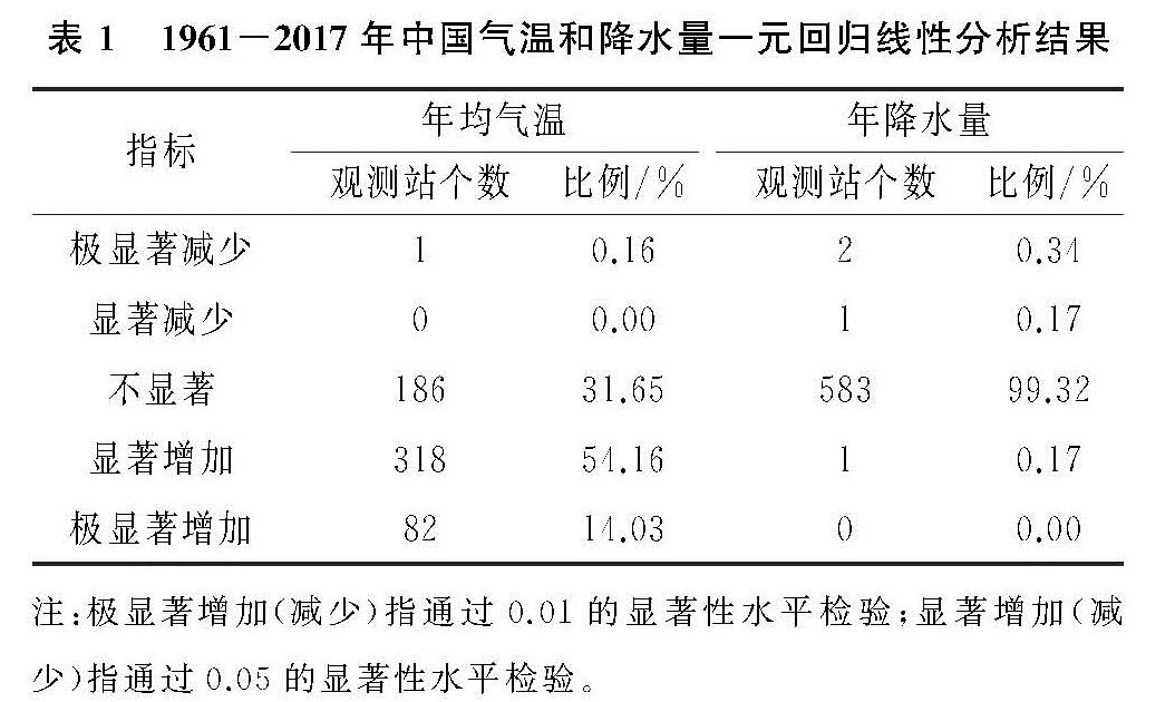
图4和表1分别为1961—2017年全国587个气象观测站点年均气温、降水量年际变化趋势及其显著性分析结果。由图4A可以看出各气象站年均气温主要呈上升趋势,即趋势斜率Slope>0,全国587个气象站中仅有6个气象站年均气温趋势斜率为负值。经统计,全国增温显著的站点数共计400个,其中呈极显著增加的82个,占全部站点数比例为14.03%(表1)。年均气温存在自东南向西北升温加速的趋势,全年增暖在北方最为显著,Slope高值区主要分布于中国偏西北地区的北方干旱半干旱农业区、青藏高原农业区、黄土高原农业区以及东北平原农业区。分析可见,中国年均气温变化在不同区域不同步,气温变化幅度与气温空间分布特征表现出一定的负相关性,而与纬度有较好的正相关性。
图4 1961-2017年中国气温和降水量年际变化趋势空间分布
表1 1961-2017年中国气温和降水量一元回归线性分析结果
图4B表明中国年降水量变化呈现较明显的区域差异,但大部分地区年降水量变化趋势并不显著(表1)。统计表明,全国气象站点中,共计348个站点年降水序列趋势斜率Slope>0,占比58.40%。华南农业区东北部、云贵高原农业区大部、长江中下游农业区大部、淮海平原农业区中南部、东北平原农业区南部、北方干旱半干旱农业区西北部以及青藏高原农业区东南部等地区降水量呈增多趋势,但增势并不显著。自中国东北至西南沿线,即东北平原农业区北部、北方干旱半干旱农业区东北部、淮海平原农业区北部、黄土高原农业区到四川盆地农业区大部等区域,年降水量有所减少,此外青藏高原农业区北方大部、长江中下游农业区东南部及华南农业区南部沿海地区,同样表现出不同程度的转干趋势。
2.2 各农业区气温、降水量变化趋势分析
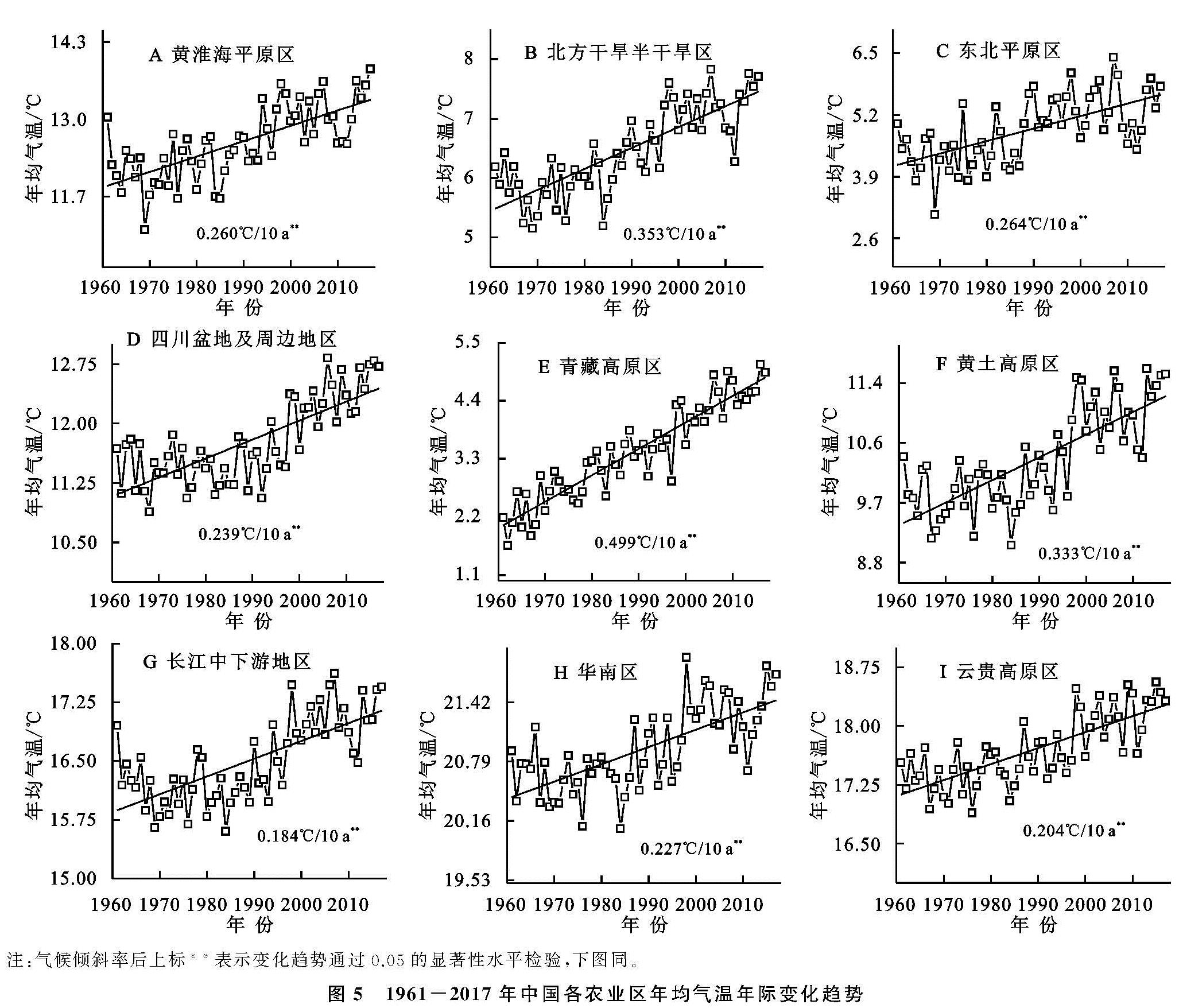
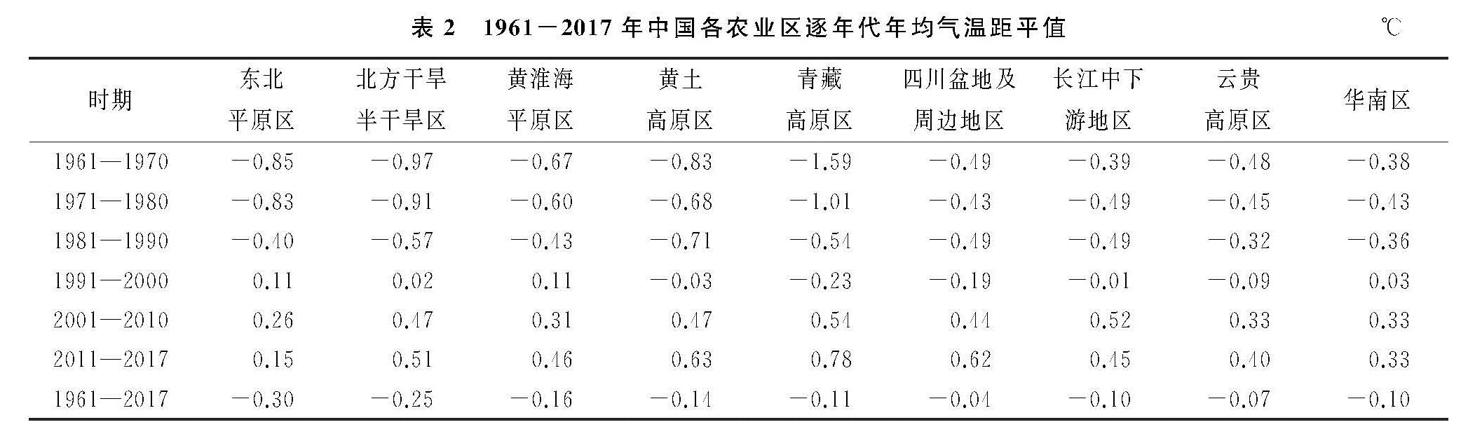
(1)年际变化。受海陆位置、地形特征及环流形势等因素共同影响,中国各农业区气候特征存在较大差异。由年均气温变化趋势及显著性水平检验可见,中国各农业区气温均呈显著上升趋势(图5,表2),其中东北平原农业区累年均温最高,达19.26℃,青藏高原农业区累年均温最低,为5.19℃。结合气候倾向率对各农业区增温幅度进行分析表明,青藏高原农业区年均气温上升幅度最大,年均温倾斜率高达0.390℃/10 a,其次为四川盆地及其周边地区,气候倾向率为0.320℃/10 a。相较而言,东北平原农业区、北方干旱半干旱农业区气温增幅较小,气候倾向率分别为0.146,0.197℃/10 a。上述研究表明近60 a间中国各区变温趋势有明显差异,北方增温速率明显大于南方地区,西部地区大于东部,青藏地区增温速率最大。
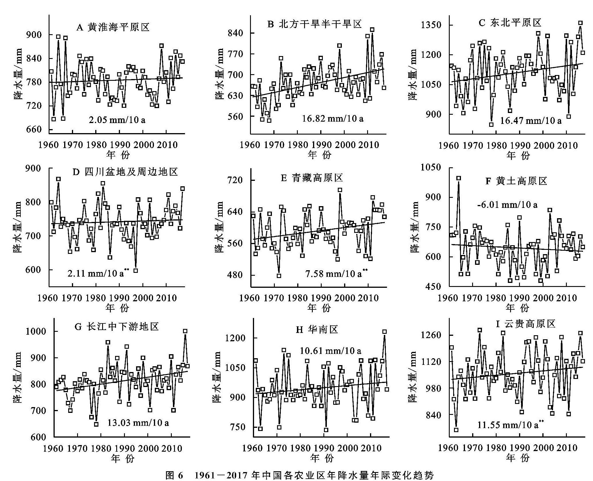
各农业区年降水总量及其年际变化趋势存在明显差异(图6),其中东北平原农业区、云贵高原农业区累年平均年降水量明显高于其他各农业区,分别为1 110.08,1 057.95 mm; 青藏高原及黄土高原农业区累年平均年降水量最低,分别为592.16,644.72 mm。由线性趋势及显著性检验可知(图6,表3),除黄土高原农业区年降水量呈不显著减少趋势外,其余各农业区年降水量表现出不同程度的增加态势。其中,北方干旱半干旱农业区、青藏高原农业区以及长江中下游农业区年降水量增势显著,其气候倾向率分别为16.82,7.58,13.03 mm/10 a。但整体来看,全国多数农业区年降水总量变化相对较为平稳。
(2)年代际变化。从各年代气温变化来看(表2),各农业区气温存在较为一致的年代际变化特征,1961—1970年、1971—1980年以及1981—1990年3个年代各区均温低于气候标准值(1981—2010年均值),1991—2000年期间为高低差异并存期,2001年后各区年代均温高于气候标准值。对整个研究时段而言,各农业区年均气温均略低于气候标准值,由图3A、图4A分析认为,该现象主要是由1981—2010年恰好处于气温稳健增长阶段所致。
图5 1961-2017年中国各农业区年均气温年际变化趋势
表2 1961-2017年中国各农业区逐年代年均气温距平值℃
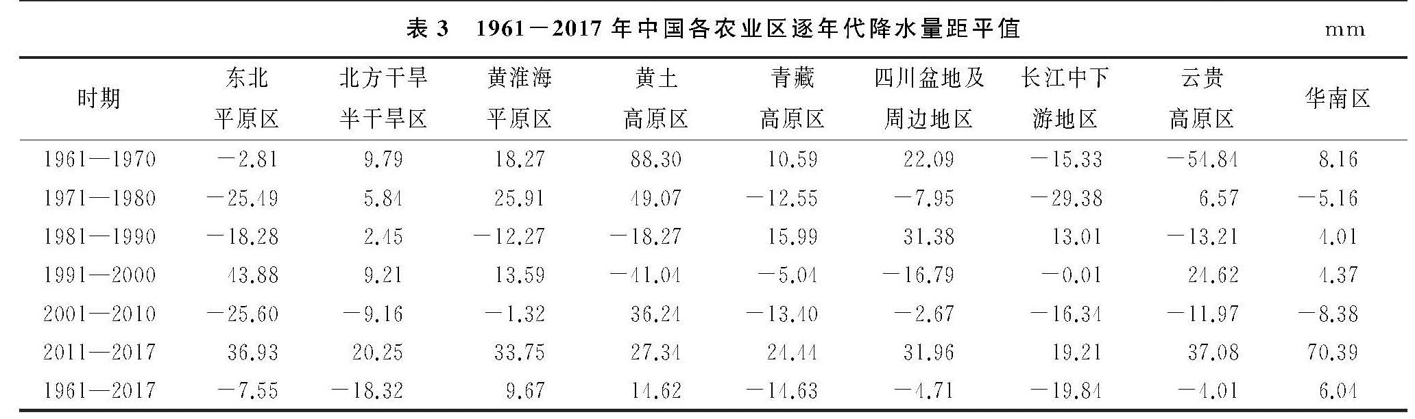
表3 1961-2017年中国各农业区逐年代降水量距平值mm
图6 1961-2017年中国各农业区年降水量年际变化趋势
各农业区降水量年代际增减趋势及地域分布亦表现出较大差异(表3),其中,北方干旱半干旱农业区、长江中下游农业区、云贵高原农业区以及华南农业区逐年代降水量呈波动增长趋势; 黄土高原农业区在2000年前年降水总量有大幅减少,2000年后由减转增,表现出“V型”变化趋势; 其余各农业区年降水量呈波动变化。整体来看,各农业区在2001—2010年有不同程度的“干化”,但在2011—2017年出现明显“湿化”。综上分析可见,对于不同空间尺度、不同时间尺度,降水量均比气温具有更明显的差异性。
2.3 气温、降水量时空变化特征分析
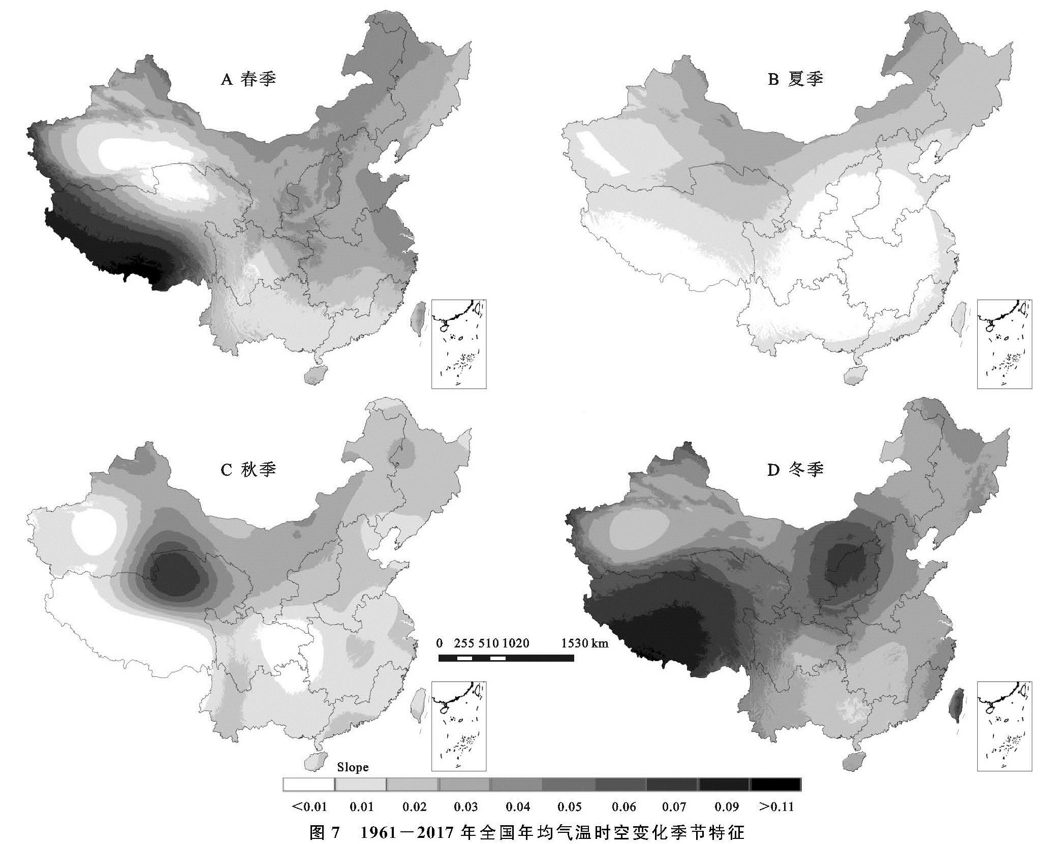
借助ANUSPLIN软件空间插值及ArcGIS可视化处理,以一元线性回归趋势斜率为参考指标,对研究区季节年均气温、年降水量长期变化趋势及空间分布特征进行分析,结果如图7—8所示。
由图7可知,升温为全国各季节年均气温长期主导变化趋势,但气温变化表现出明显的季节性空间差异,即各季、各区变温趋势和幅度各不相同。春季,Slope高值主要出现在青藏高原农业区南—西南区域,其次为西北、华北地区,涉及黄土高原农业区、黄淮海平原农业区、东北平原农业区以及北方干旱半干旱农业区东部等农业区; Slope低值多分布于西北盆地(塔里木盆地、柴达木盆地)。夏季增温趋势呈“北高南低”态势,北方干旱半干旱农业区、东北平原农业区以及青藏高原农业区东北部在夏季具有长期增温潜势(图7B)。图7C表明秋季除青藏高原农业区南部局地外,中国大范围地区存在长期小幅增温趋势,其中柴达木盆地及其周边地区增势最高。冬季增温趋势空间分布差异分明,青藏高原农业区、黄土高原农业区趋势斜率明显高于其余各农业区(图7D)。可见,春、冬季增温是导致青藏高原农业区增温幅度最大的直接原因。
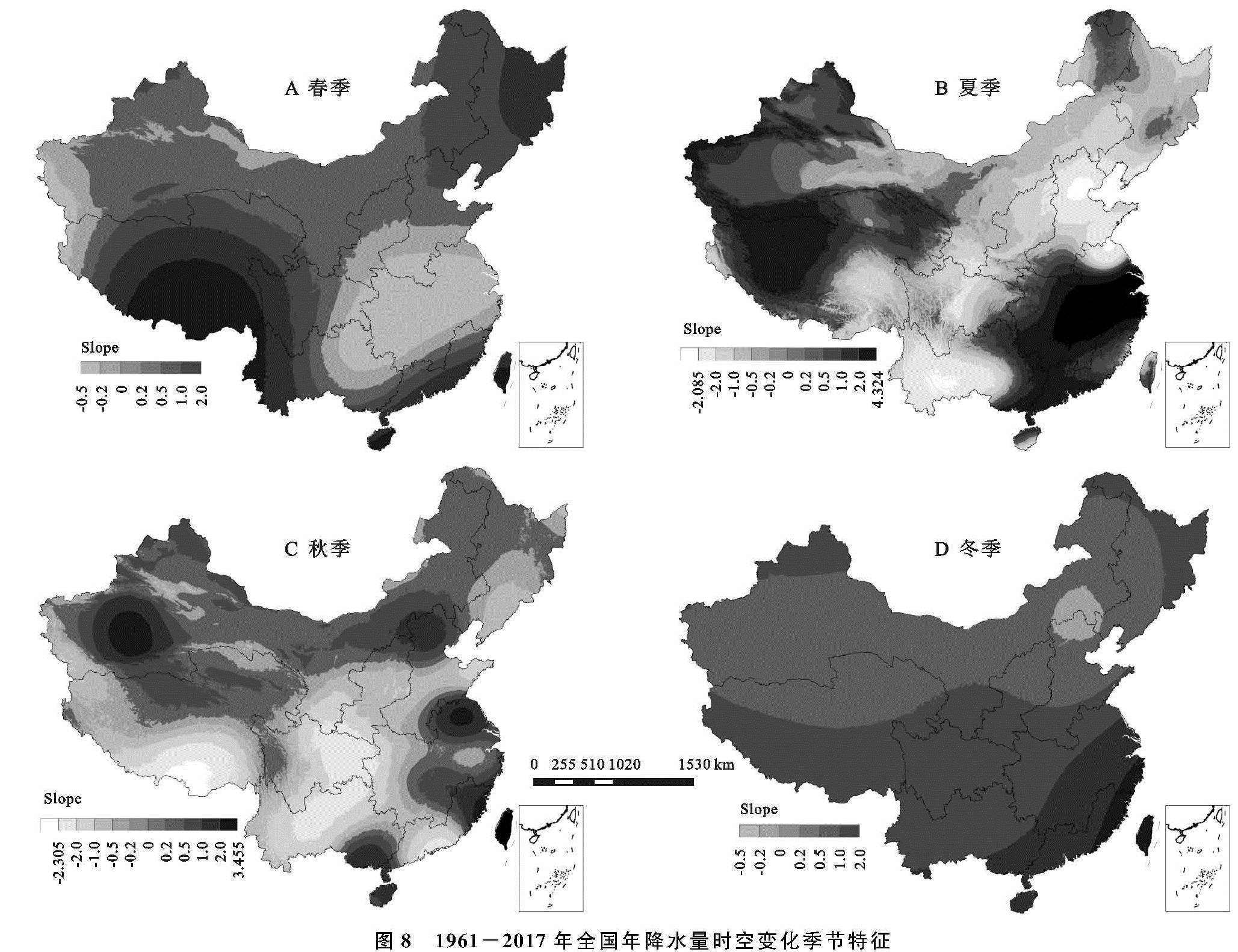
与春季年均气温变化趋势地理分布相仿,中国春季年降水量主要增长区集中在青藏高原农业区南部,华南农业区沿海、东北平原农业区东部等区域次之(图8A)。夏、秋两季中国年降水量变化趋势空间差异性较大,其中夏季累年降水量在东南沿海、西北内陆两大区位出现明显上升趋势,并以长江中下游农业区增势最大,其次为华南农业区、云贵高原农业区东部、青藏高原农业区大部以及北方干旱半干旱农业区西部边缘等地区; 云贵高原农业区、四川盆地及周边地区、黄土高原农业区、黄淮海平原农业区以及东北平原农业区年降水量主要呈现下降趋势(图8B)。秋季,东南沿海局部、北方干旱半干旱区大部呈降水增加趋势,云贵高原农业区、四川盆地及周边地区、青藏高原农业区南部、华南农业区南部以及黄土高原农业区等表现为明显“转干”趋势(图8C)。冬季年降水量在全国范围内均有微弱增长,增加趋势由东南沿海向西北内陆地区递减(图8D)。
图7 1961-2017年全国年均气温时空变化季节特征
由各季年降水量趋势斜率Slope值可见,夏、秋两季年降水量变化较为极端,Slope最大值分别为4.324,3.455,最小值为-2.082,-2.305,均小于春、冬两季Slope最大(小)值,说明夏季、秋季局部区域降水量极端增(减)趋势更为突出。对四季Slope值落区进行统计,各季Slope<0的观测站个数分别为226(38.50%),315(53.66%),338(57.58%),97(16.52%),表明中国年降水量降低趋势具有秋季>夏季>春季>冬季的季节差异,与此同时,夏季、秋季极端降水发生频率有递增趋势,但具有明显区域性和局地性。