2.1 灌区渠系结构特征
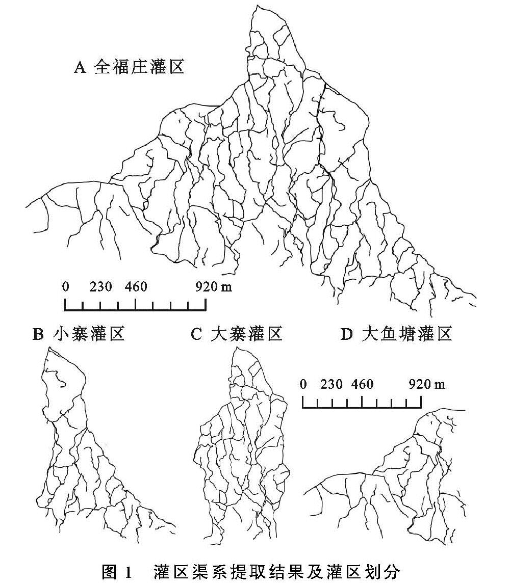
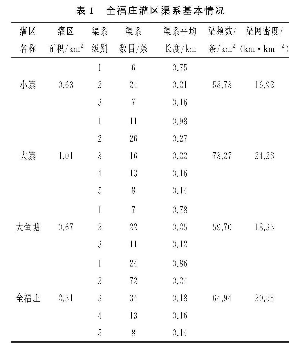
以元阳梯田典型灌区全福庄灌区的无人机遥感影像为基础资料,按照从灌区源头引水的次序对渠系进行分级,从源头直接引水出来的为1级渠系,从1级渠系引水出来的为2级渠系,从2级渠系引水出来的为3级渠系,以此类推下去。利用上述公式来计算灌区渠系结构参数特征,计算结果见表1。
由表1可知,全福庄灌区内渠系级别最高为5级,而且仅在大寨灌区出现5级渠系情况,小寨和大鱼塘灌区内渠系级别最高为3级,可能的原因是大寨灌区灌溉面积较大,其渠系分级就越多,渠系结构越复杂。灌区内渠系总量为151条,其中1级渠系24条,2级渠系72条,3级渠系34条,4级渠系13条,5级渠系8条。1级渠系平均长度都在其余渠系长度两倍以上,1级渠系贯穿于整个灌区中,主要是为了引水和输水。
渠频数和渠网密度是衡量渠系结构的重要指标。在相似条件下渠网密度越大,渠道输水流量越大,对灌区的发展越有利。表1中全福庄亚灌区中的渠频数和渠网密度都表现出随着灌区面积的增大,渠频数和渠网密度都增加的趋势。其中大寨灌区的面积为1.01 km2,在3个灌区中最大,其相应的渠频数(73.27条/km2)和渠网密度(24.28 km/km2)也最大,小寨灌区的相对偏小,分别为58.73条/km2,16.92 km/km2,其面积也最小(0.63 km2)。通过实地调查发现,小寨灌区内的灌溉渠系在旱季会出现部分沟渠断流的情况,而且梯田的蓄水位也要低于其它灌区。造成这种现象的原因可能是:小寨灌区的渠网密度要低于其它灌区,输水量就有所减少。灌区内灌溉渠系的水源除了来自梯田上方的水源林外,还有部分村寨里面的生活废水排入,而小寨灌区村寨比其它灌区小,其生活废水量较其它灌区少。另外大鱼塘灌区上部建有小型水库,把雨季多余的雨水蓄积起来,在旱季的时候又把水放入梯田中,充分利用水资源,保证灌溉。
研究区内的渠系结构特征指标总体上处于一个较高的水平。有研究表明,渠网密度与降雨量呈正相关关系,即一般在降雨量较大的地区,渠网密度也相对较大[14]。研究区多年平均降雨量为1 375 mm,降雨量丰富,与研究区实际情况相符。
2.2 灌区的分形维数
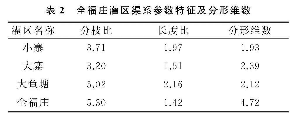
现有研究表明,河流水系的分支比取值范围是3~5,长度比取值范围是1.5~3,分形维数取值范围为1~3。通过表2计算结果可知,全福庄灌区灌溉渠系的分支比、长度比及分形维数均不符合Horton河系定律的合理取值范围。其中分支比(5.3)偏大,长度比(1.42)偏小,导致分形维数(4.72)偏大。这说明人工渠系与天然水系存在差异性,人工渠系受人为影响,其水流方向和渠系长度都发生了变化,在全福庄灌区内尤其是2级渠系受人工改造表现明显。为了适应大坡度的山地环境,元阳梯田在修建时梯田斑块面积要比一般灌区的小,为了保证每块梯田都有充足的水源,就需要修建更多的人工渠系来维持灌溉。
把全福庄灌区分为3个亚灌区,但其分支比、长度比、分形维数都不是叠加关系。小寨灌区分支比、长度比、分形维数均在取值范围内,但分形维数值(1.93)偏低,说明小寨灌区渠系结构比较简单,在今后的渠系改造中可适当通过提高分支比来增加分维数。大寨灌区的长度比(1.51)偏低,反映出该灌区下一级渠系长度偏低,在保持1级渠系引水长度不变的情况下,应适当增加下一级渠系长度,来增加其长度比。大鱼塘灌区的分支比(5.02)略大于现有研究分支比取值范围,说明大鱼塘灌区2级、3级渠系数量偏多,可通过适当增加1级渠系或减少2级、3级渠系来降低其分支比。
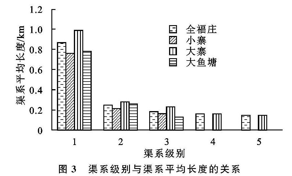
2.3 渠系级别与渠系数目、渠系平均长度的关系
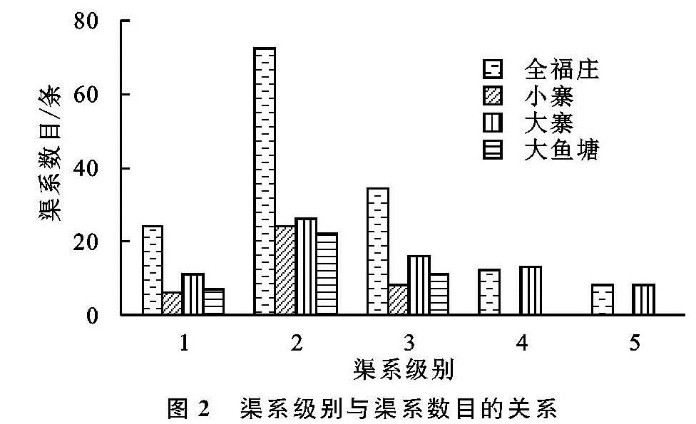
通过对全福庄及其亚灌区渠系级别与渠系数目、渠系平均长度的关系进行分析做图2和图3,分析其变化规律。
由
图2可知,无论是全福庄总灌区还是其亚灌区,其渠系级别与渠系数目都呈现出1级渠系到2级渠系成倍增长然后又缓慢下降的趋势,而且渠系级别越多,其渠系总数量就越多。2级渠系占了全福庄灌区总量的48%,因为1级渠系主要负责从水源处引水和接纳梯田出水口处的排水,2级渠系负责对1级渠系的水量进行再分配,保证其充分灌溉到各块梯田中,由此可见,2级渠系在全福庄灌区水量分配中起着控制性作用。在今后的渠系改造和维修中,应更加注重2级渠系的发展状况。
由图3可知,灌区内随着渠系级别的增加,渠系平均长度呈现逐级递减的趋势。大寨灌区的各级渠系平均长度都要大于其它灌区,原因是大寨灌区控制的灌溉面积较大,输水的距离较长,其渠系平均长度也就越长,反之小寨灌区由于灌溉面积较小,其需要的输水距离就短,渠系平均长度也就越短。
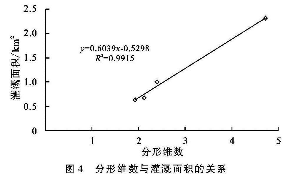
2.4 分形维数与灌溉面积的关系
对全福庄及其亚灌区的灌溉面积与分形维数关系进行分析,绘制了图4。从图4各灌区灌溉面积与分形维数关系可以看出,灌区灌溉面积越大,其分形维数越大。全福庄灌区的灌溉面积为2.31 km2,分形维数为4.72,甚至超过了Horton河系定律的合理取值范围。因为灌溉面积越大,越需要丰富的渠系结构作为保障,其渠系结构就越复杂[15]。渠系的分形维数总体上可以反映灌区渠系复杂程度,渠系分维值越大,渠系复杂程度越高,渠系对于灌区的填满程度就越高。正是如此高密度和复杂的渠系结构才维持了元阳梯田终年淹水的机制。