3.2.1 1990—2000年土地利用空间序列变化图谱
1990—2000年期间江汉平原土地利用变化中共有36类图谱单元(总面积28 287.66 km2),有30类发生了变化(541.27 km2,占比1.91%),将占变化面积98.89%的13类图谱单元按面积大小排序(表4)。
由表4和附图1A可知,1990—2000年土地利用变化以“耕地—水域”(编码14)为主,占比67.18%,主要是基于原有水域的扩张,分布在江汉平原东部的仙桃市、洪湖市等低湖平原区; 其次是“耕地—建设用地”(编码15),占比13.54%,主要是各县市的向外扩张和内部填充,分布在研究区北部; 第三是“水域—耕地”(编码41),占比8.66%,分布在研究区南部和东部; 第四是“水域—草地”(编码43),占比2.22%,分布在研究区西南和东北片。
表4 1990-2000年土地利用变化主要图谱单元排序
该阶段土地利用变化主要是耕地和水域间互相转换、耕地转变为建设用地。耕地主要流向水域、建设用地和林地,累计转出比例82.09%; 同时部分水域、林地转变为耕地,累计转入比例9.76%。尤为显著的是耕地转化为水域,其次是耕地转化为建设用地。
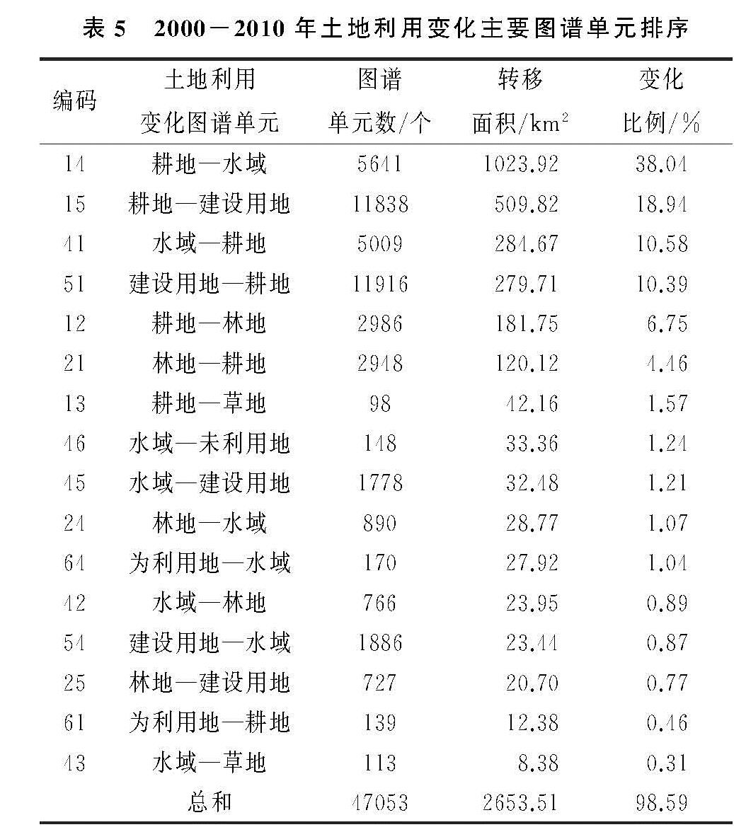
3.2.2 2000—2010年土地利用空间序列变化图谱
2000—2010年江汉平原土地利用变化中共有36类图谱单元(总面积28 287.66 km2),有30类图谱单元发生变化(2 691.56 km2,占总面积的9.51%)。将占变化区域面积98.59%的16类图谱单元按面积大小排序,并计算其变化比率(表5)。
由表5和附图1B可知,2000-2010年土地利用变化以“耕地—水域”(编码14)为主,占比38.04%,仍是基于原有水域的扩张,但其变化面积和空间分布范围增加,由原本处于低湖平原区的仙桃市、洪湖市扩散到监利县和汉川市; 其次是“耕地—建设用地”(编码15),占比18.94%,主要在研究区北片; 第三是“水域—耕地”(编码41),占比10.58%,主要在研究区中部和东部; 第四是“建设用地—耕地”(编码51),占比10.39%,主要在研究区西南片和西北角。
2000—2010年,该时期耕地和水域间的互相转化、建设用地占用耕地的面积进一步扩张,并出现建设用地转化为耕地的情况。耕地主要流向水域、建设用地、林地和草地,转出的面积大幅度增长,但累计转出比例降低为65.3%; 同时,耕地主要转入来源为水域、建设用地和林地,新增一项建设用地,且其他类用地转入面积均明显增加,累计转入比例达到25.43%,较上一阶段增加了15.67%。最为显著的仍是耕地转变为水域,其次是耕地转变为建设用地。
总体来看,1990—2010年江汉平原土地利用变化图谱主要表现为以下几个特征:
一是耕地和水域间的互相转化,主要在仙桃市、洪湖市等低湖平原区,原因是国家政策驱动。随着1998年特大洪水后的大江大河治理、长江平垸行洪、退田还湖、移民建镇和1999年生态退耕政策的实施,区域内耕地大幅度转化为水域。该区域增加的水域主要是鱼塘,人民对于鱼类产品的需求以及养鱼的良好收益,促使耕地持续转化为水域。而2004年后粮食直补政策和粮食价格的持续上升使得部分鱼塘重新转化为耕地[16-17],后期水域转化为耕地的面积有所增加。
二是耕地和建设用地间的互相转化。其中耕地转化为建设用地贯穿整个时段,主要发生在经济相对发达的各县市城区周边区域,其转化原因涉及到国家政策、城市化进程和人口增长等各方面。前期受房地产热、开发区热和建房修路热的影响,江汉平原建设用地快速扩张; 后期国家推行中部崛起战略,区域交通设施建设占用大量农用地并带动沿线投资[18],耕地转化为建设用地显著; 人口增加也是影响建设用地增长的重要因素。建设用地转化为耕地发生在后期,集中在石首市、松滋市等地,究其原因,城乡建设用地增减挂钩政策和全国土地开发整理规划促使闲置的农村建设用地得到整理复垦,建设用地转变为耕地。
表5 2000-2010年土地利用变化主要图谱单元排序
3.3 土地利用涨落势图谱
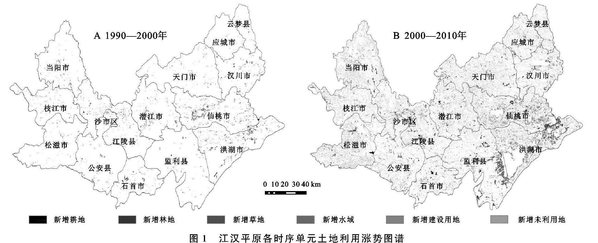
3.3.1 1990—2010年土地利用涨势图谱
根据土地利用的“转入”进行重分类,得到江汉平原两个时序单元的涨势图谱,并通过相交工具对江汉平原内各行政单元的差异和变化进行分析(图1)。
1990—2000年,江汉平原内变化区域总面积是541.27 km2,未变区域总面积为27 746.39 km2,分别占该区域总面积的1.91%,98.09%。变化区域中按新增面积大小排序分别是水域、建设用地、耕地、草地、林地和未利用地。其中新增水域面积最大,是376.03 km2,占新增总面积的69.47%。其次是新增建设用地、新增耕地和新增草地,分别是81.45,55.14,12.38 km2,最小的是新增林地(8.73 km2)和新增未利用地(7.59 km2)。
江汉平原内各县市土地利用变化存在很大差异,沙市区土地利用变化最为活跃,其未变区域占比最低(94.76%); 应城市土地利用变化最为稳定,其未变区域占比最高(99.68%); 监利县和松滋市的土地利用变化相对稳定。研究区域内汉川市的新增耕地面积最大,是8.96 km2,但没有新增林地; 石首市的新增林地、草地和未利用地面积最大,分别是1.76,12.06,2.87 km2; 仙桃市的新增水域面积最大,是108.23 km2; 枝江市的新增建设用地面积最大,是17.71 km2。
2000—2010年期间,江汉平原土地利用变化区域占总面积的比例为9.51%,相对于上一阶段增长7.6%,变化区域中按新增面积排序是水域、耕地、建设用地、林地、草地和未利用地。新增水域的面积依然是最大的,为1 123.62 km2,占总体新增面积的41.75%; 其次是新增耕地面积,新增的面积比上一阶段多了637.21 km2,说明土地整理对于增加耕地的作用明显; 再者是新增建设用地,比上一阶段增加了483.5 km2,说明江汉平原的城市化建设从未停止; 新增林地和上一阶段相比增加了204.23 km2,其中新增林地幅度明显增大,说明该时期生态用地的保护明显加强; 新增草地相对增长41.08 km2; 最小的是新增未利用地。
沙市区的土地利用变化仍然最为剧烈,其未变区域占比78.75%; 公安县未变区域占比最大,土地利用变化最为稳定,云梦县和当阳市的土地利用变化相对稳定。土地利用类型涨势图谱在县区内存在明显差异:松滋市的新增耕地(69.38 km2)、林地(70.57 km2)面积最大,但没有新增的未利用地; 当阳市的新增耕地面积仅次于松滋市,为60.95km2,且各县市间新增耕地的面积差距变小; 洪湖市的新增草地(28.60 km2)和新增水域面积(326.06 km2)最大,其中仙桃市和监利县的新增水域仅次于洪湖市,分别为255.32,223.83 km2,水域增加主要在水资源丰富的低湖平原区; 天门市的新增建设用地最大(79.26 km2),仙桃市、江陵县和潜江市次之,分别为69.74,57.38,57.13 km2,各县市新增建设用地的面积相对于上一阶段皆有大幅度的增加; 石首市的新增未利用地最大(13.99 km2)。
3.3.2 1990—2010年土地利用落势图谱
土地利用的“转出”类型进行重分类,得到江汉平原两个时序单元的落势图谱,并通过相交工具对江汉平原内各行政单元的差异和变化进行分析(图2)。
1990—2000年,江汉平原内按萎缩面积排序是耕地、水域、林地、未利用地和草地。其中耕地减少的面积最大,为442.61 km2,占整体萎缩面积的81.77%; 其次为水域72.42 km2,占比13.38%; 再者是林地11.39 km2; 未利用地和草地的萎缩面积均小于10 km2,建设用地的萎缩面积最小。江汉平原内土地利用变化存在明显差异:仙桃市耕地萎缩面积最大,为115.13 km2,洪湖市次之; 当阳市林地萎缩面积最高,为3.16 km2; 石首市草地和水域的萎缩面积最高,分别是1.98,16.82 km2; 洪湖市建设用地和未利用地萎缩面积最高,分别是7.04,0.50 km2。
2000—2010年期间,江汉平原内各类土地利用类型的萎缩面积相对于上阶段有明显增加,按面积大小为耕地、水域、建设用地、林地、未利用地和草地。耕地的萎缩面积依然是最高,为1 775.93 km2,是上一阶段的4倍,该阶段耕地被转化和占用的趋势进一步加强; 其次是水域382.10 km2,是上一阶段的5倍; 再者是萎缩建设用地304.02 km2,从上一阶段的最末位上升为第3位,说明土地整理和增减挂钩政策使建设用地大量转化为耕地; 林地和未利用地的萎缩面积有所增加,草地的萎缩面积最小,变化较不明显。
各土地利用类型的落势图谱在县市内有所差异。其中洪湖市的耕地萎缩面积最大,为360.76 km2,仙桃市次之,其余各县市的耕地萎缩面积相对于上一阶段来说都明显增加; 松滋市萎缩林地最多,为44.45 km2,当阳市次之; 石首市萎缩草地最多,10.39 km2; 监利县的萎缩水域面积最高,仙桃市次之,且各县市的萎缩水域面积相较于上一阶段皆有所增长; 洪湖市的萎缩未利用地面积最大,为9.06 km2。
将土地利用变化图谱和涨落势图谱相结合,探索三者间的数量和空间关系,分析江汉平原土地利用的时空变化特征。1990—2000年,江汉平原的土地利用涨落势图谱中,新增水域376.03 km2,萎缩耕地442.61 km2,土地利用变化图谱中最为显著的是耕地转化为水域(编码14),面积365.25 km2,结合三者间的数量关系说明前期水域的主要来源是耕地,且三者都集中在低湖平原区,新增水域都是基于现有水域的边缘。2000—2010年,江汉平原的土地利用涨落势图谱中,新增水域1 123.62 km2,新增建设用地564.95 km2,萎缩耕地1 775.93 km2,而土地利用变化图谱最显著的是耕地转化为水域(编码14),1 023.92 km2,再者是耕地转化为建设用地(编码15),509.82 km2; 结合五者之间的数量关系说明研究后期水域和建设用地的主要来源是耕地,且水域的变化都集中在低湖平原区,建设用地相关变化集中在经济发达的各县市周边区域。
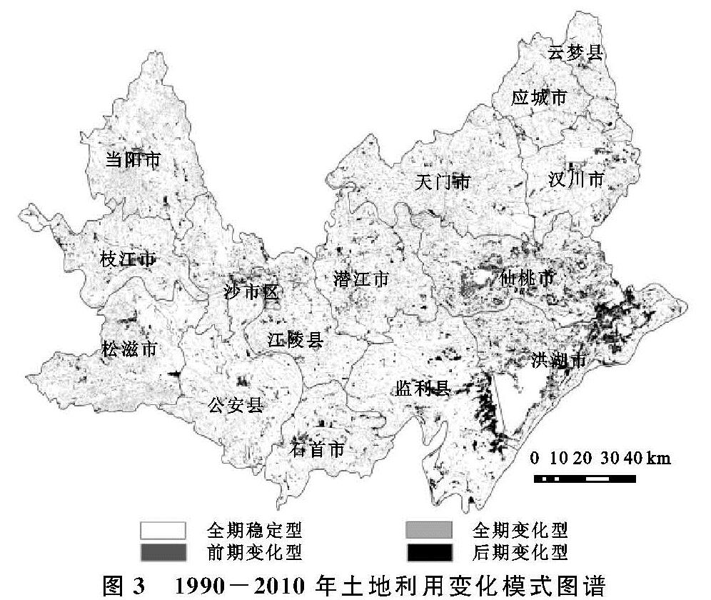
3.4 土地利用变化模式图谱
根据1990年、2000年、2010年3期土地利用现状数据,重构得到1990—2010年土地利用变化模式图谱(图3),按照阶段性变化特征分为四大变化模式(表6)。
由图3,表6可知,1990—2010年,全期稳定型模式占据主要地位,占总面积的89.17%,主要为耕地、水域和林地。与之相对的是全期变化型,占比0.29%,主要分布在江陵县、仙桃市和潜江市,以耕地—水域—耕地和水域—耕地—水域的反复变化图谱为主。第二位是后期变化型,占比8.92%,主要是洪湖市、仙桃市和监利县(低湖平原区),以耕地—耕地—水域和耕地—耕地—建设用地的变化图谱为主。第三位是前期变化型,占比1.63%,主要是仙桃市、洪湖市和潜江市,以耕地—水域—水域和耕地—建设用地—建设用地的变化图谱为主。