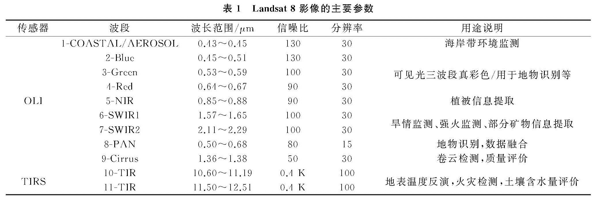
3.1 土壤含水量与实测土壤含水量精度验证
为了进一步验证植被供水指数遥感监测水分的效果,本文采用一元线性回归相关分析对实测土壤含水量数据与遥感数据获得的VSWI指数做线性关系,利用ENVI软件提取与遥感成像日期接近的遥感影像上土壤含水量反演值进行土壤含水量反演值与实测数据的相关性分析检验,并进行线性拟合,观察土壤含水量反演值与实测数据的拟合效果(图3)。
图3 基于Landsat 8遥感数据的土壤含水量反演值与实测数据线性拟合结果
结果显示,土壤含水量反演值与实测数据呈一定的正相关关系,通过显著性检验(p<0.01),说明基于Lansdat 8遥感数据的土壤含水量反演在一定程度上能够较好地反映土壤含水量的实际情况,可以利用Landsat 8影像进行土壤含水量反演。其系数R为0.62,标准误差为0.01。
3.2 土壤含水量时空分布特征
3.2.1 空间分布特征
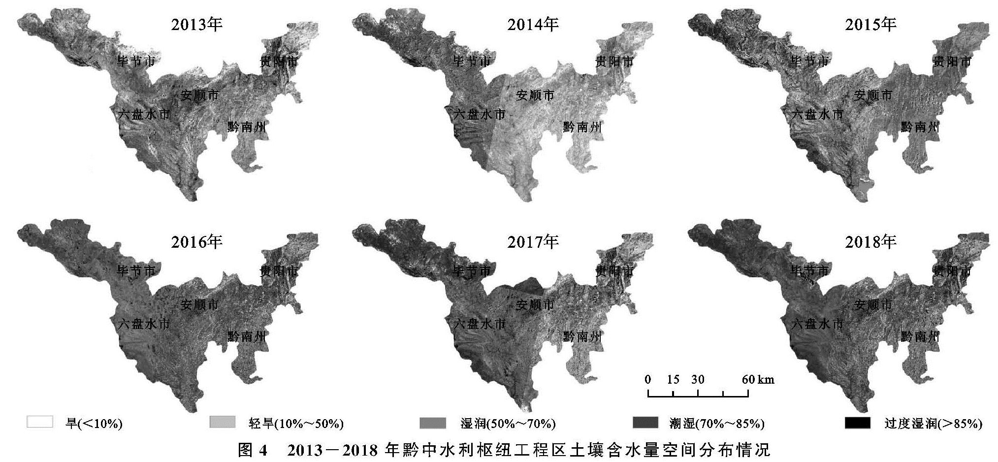
根据黔中水利枢纽地区土壤含水量分布情况,将研究区的土壤含水量状况分为5级[24]:旱(<10%)、轻旱(10%~50%)、湿润(50%~70%)、潮湿为(70%~85%)、过度湿润(>85%)。从2013—2018年黔中水利枢纽工程区土壤含水量分布状况(图4)来看,主要以湿润和潮湿为主。黔中水利枢纽地区的中部地带土壤含水量情况主要为湿润,而潮湿主要分布在黔中水利枢纽的西南部地区,过度湿润部分地段处于黔中水利枢纽地区西部地带,而黔中水利枢纽地区的东北部地段为轻旱。
2013年土壤含水量整体较差,呈“北部和东北部低、中间高”的分布特征,土壤含水量最高的地区是安顺市中部和贵阳市中部,以过度湿润为主,平均土壤含水量为14.78%,贵阳市东北部、毕节市北部是水分较差的地区,以旱和轻旱为主,平均土壤含水量为24.09%。2014年土壤含水量呈“西部高、东部低”的分布特征,土壤含水量在毕节市、六盘水市较为丰富,以潮湿和过度湿润为主,平均含水量为31.43%,土壤含水量较低的地区有黔南州和贵阳市东北部,以旱为主,平均土壤含水量为7.92%。2015年土壤含水量呈“西南和东北高、中部低”的分布特征,土壤含水量等级以湿润为主,土壤含水量最高的地区主要分布在毕节市、贵阳市、安顺市南部和东北部,平均含水量为22.72%。2016年土壤含水量空间分布差异明显,潮湿、过度湿润分布面积逐渐增加,旱、轻旱分布面积逐渐减小,整体以潮湿为主,平均土壤含水量为61.67%,呈“中部高、四周低”的分布特征。2017年土壤含水量空间分布呈“西部高、东南部低”的特征,过度湿润主要分布在毕节市(2.38%)、六盘水市(5.47%)和安顺市(13.98%),旱主要集中分布在贵阳市乌当区,平均土壤含水量为0.02%。2018年土壤含水量整体较好,呈“西部高、东部低”的分布特征,主要以潮湿为主,分布在毕节市、六盘水市,土壤含水量最高的地区是毕节市,平均土壤含水量为2.49%,贵阳市是土壤含水量较低的城市,平均土壤含水量为1.27%。
图4 2013-2018年黔中水利枢纽工程区土壤含水量空间分布情况
3.2.2 时间分布特征
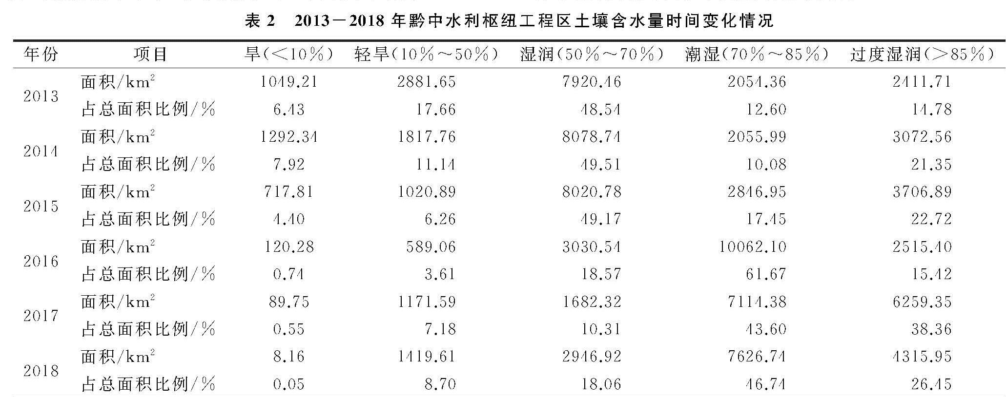
2013—2018年研究区平均土壤含水量分别为80.60%,77.40%,82.10%,82.90%,81.20%,83.60%。土壤含水量状况整体表现出波动升高的趋势,年平均增速为0.91%,其中,从2013—2014年,土壤含水量整体呈下降趋势,年平均降速为-1.00%; 而2014—2015年,土壤含水量呈上升趋势,年平均增速为1.48%。2013—2018年平均土壤含水量各类型(表2)发生明显变化。
表2 2013-2018年黔中水利枢纽工程区土壤含水量时间变化情况
2016年与2015年相比,潮湿类型所占比例明显上升,面积从2 846.95 km2上升到10 062.10 km2,旱类型所占比例下降幅度最大,面积由717.81 km2下降到120.28 km2; 2017年与2016年相比,过度湿润类型所占比例上升最明显,面积增加了3 743.95 km2,旱类型所占比例呈下降趋势,面积减少了30.53 km2; 2018年与2017年相比,土壤含水量各类型面积差异不大。总体上,2018年土壤含水量状况优于2013年。2013年、2014年和2015年,土壤含水量集中分布在50%~70%,其面积分别占贵州省黔中水利枢纽地区总面积的48.54%,49.51%,49.17%; 2016年、2017年和2018年土壤含水量则集中分布在70%~85%,其面积比分别为61.67%,43.60%,46.74%。整体上来看,2013年和2014年的土壤含水量较低,在50%以下的土壤含水量所占地区的面积最大比例分别为24.09%,19.06%; 2016年、2017年和2018年土壤含水量相对较高,在70%以上的土壤含水量地区面积最大,其所占比例分别达到77.08%,81.96%,73.19%。
3.2.3 土壤含水量动态分析
研究区土壤含水量的各类型面积变化差异显著(表3)。面积增加最大的是土壤含水量为70%~85%,增加了5 572.39 km2,变化率为34.15%,且动态度最大,为13.56%; 面积减少最大的土壤含水量类型为50%~70%,减小了4 973.54 km2,变化率为-30.48%,且动态幅度为-3.13%; 动态幅度最小的是土壤含水量类型为<10%,2013—2018年面积减少了1 041.05 km2。
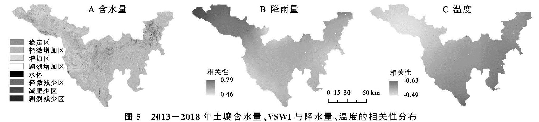
通过2013年和2018年土壤含水量叠加分析,将计算得到的土壤含水量面积变化率分为7级:剧烈减少区(变化率<-30%)、减少区(-30%≤变化率<-10%)、轻微减少区(-10%≤变化率<-5%)、稳定区(-5%≤变化率<5%)、轻微增加区(5%≤变化率<10%)、增加区(10%≤变化率<30%)和剧烈增加区(变化率≥30%)。得到近6年来土壤含水量变化的专题图(图5A),研究区土壤含水量面积变化幅度以增加为主。其中占总面积百分比最小的是稳定区,面积仅有1 940.14 km2,最大的是剧烈增加区,面积为2 394.25 km2。土壤含水量剧烈增加区主要位于工程区西北、西南部和东北部,包括毕节市、六盘水市、安顺市和贵阳市北部,一方面是研究区涉及到整个长江的三岔河及其支流、猫跳河、南明河以及珠江的打邦河和格凸河,为响应“守护绿水青山,共建绿色长江”的号召,区域水土保持整治得到了可观的改善; 另一方面,近几年政府加大岩溶地区石漠化的综合治理,加强退耕还林,还草、封山育林等工程性措施的实施,使得研究区的森林得到了较好的保护,有利于植被生长,土壤含水量也大幅度增加。总体上,2013—2018年土壤含水量态势较好。
3.3 土壤含水量与降水量、温度的关系
降水是土壤含水量的主要来源之一,土壤含水量的空间分布、年纪变化都与降水量特征有着密切的关系,黔中水利枢纽工程区内的土壤含水量消耗方式主要有植被蒸腾和地表蒸发,而气温对植物蒸腾和地表蒸发有一定的影响,因此,温度因子会对土壤含水量变化产生间接的影响。为探讨工程区内土壤含水量空间变化的主要因素,将气象站点2013—2018年降雨和温度数据进行反距离插值,得到不同时期的降雨量和温度插值的空间分布情况,然后利用ArcGIS中的地图代数工具计算2013—2018年VSWI与降水量、温度的相关性分布图,其结果如图5B—C所示。
图5 2013-2018年土壤含水量、VSWI与降水量、温度的相关性分布
黔中水利枢纽工程区2013—2018年的土壤含水量与降雨量、温度有相关性。其中,土壤含水量与降雨量相关性较高的主要集中在贵阳市、毕节市、安顺北部、六盘水东北部等部分区域,此部分区域以高原、山地为主,是典型的岩溶山区,山峦众多、沟壑纵横,气候温和、降雨充沛; 较低区域主要集中在安顺南部以及黔南等部分地区,与同期的土壤含水量空间分布格局相吻合,相关性系数取值在(0.46,0.79)区间,其中,在毕节等部分地区呈高度相关,在其余地区呈中度相关,且为正相关关系。土壤含水量与温度相关性较高的主要集中在安顺市南部、黔南州等部分区域,此部分区域以山地丘陵为主,耕地分布广泛,人类活动强烈,对土壤含水量的空间分异有一定程度的影响; 相关性为低的主要集中在安顺市北部、毕节和六盘水市部分地区,两者的相关性值区间在(-0.49,-0.63),为中度负相关。综上所述,2013—2018年研究区土壤含水量与气温、降雨量有相关性。