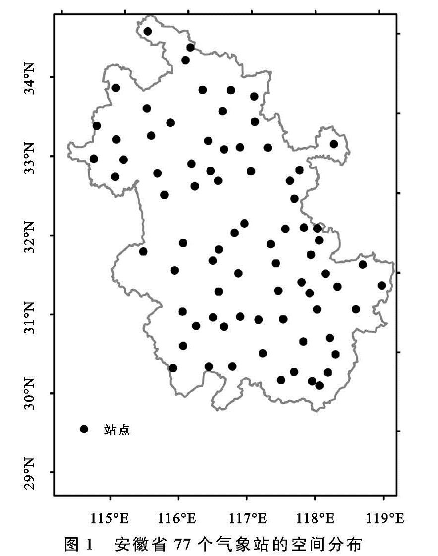
2.1 强降水的空间分布
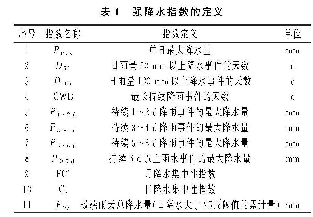
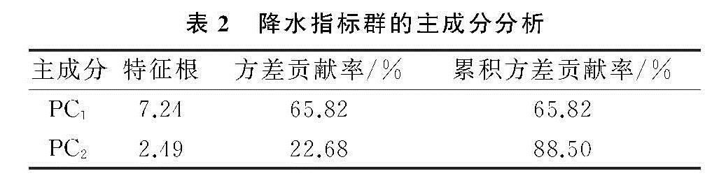
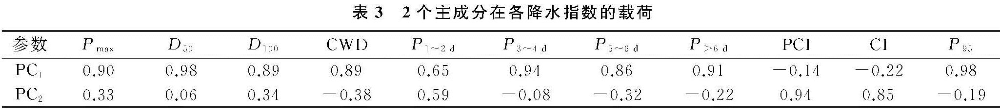
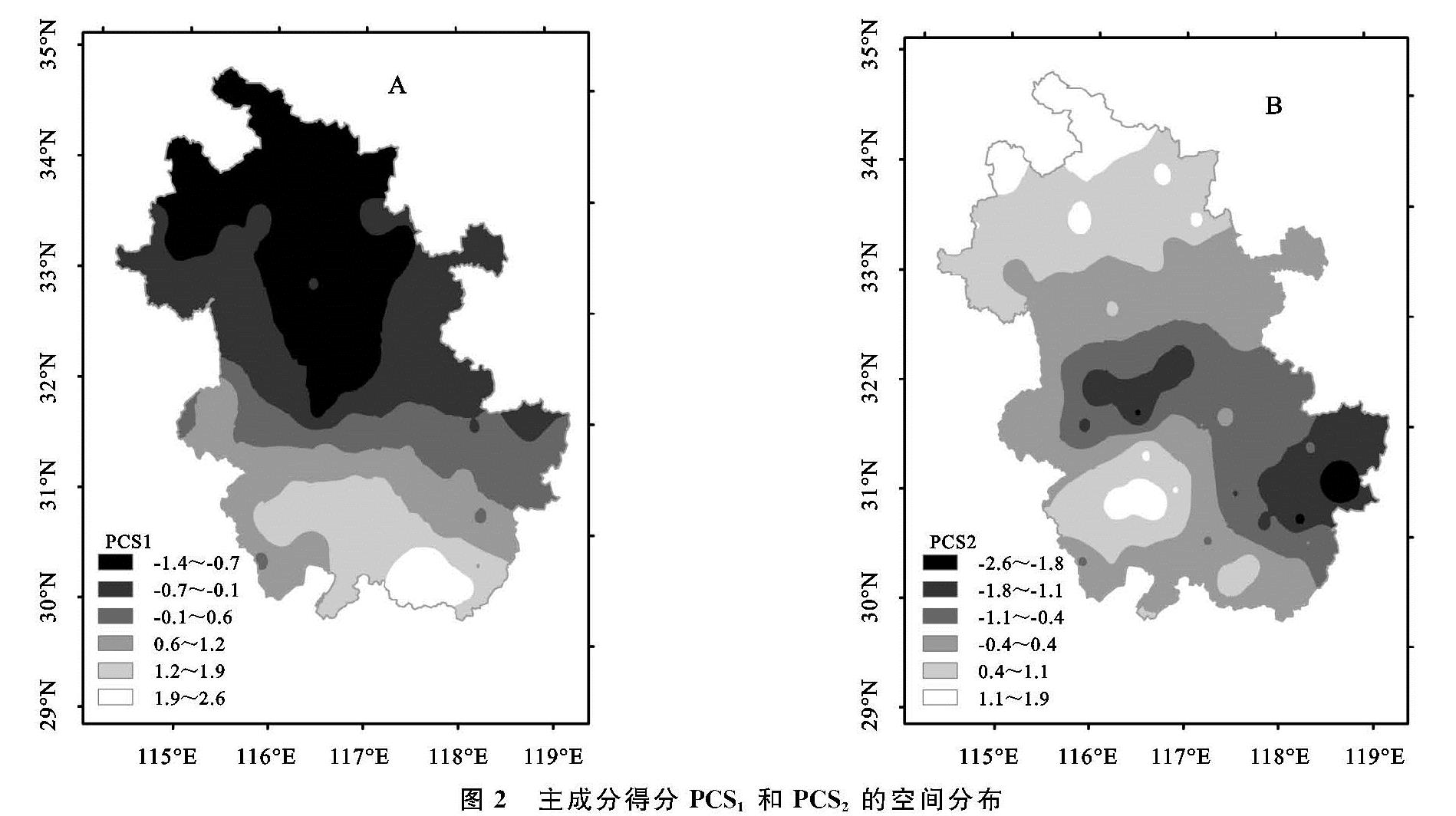
首先计算了安徽省各站点11种降水指数的多年均值,将其构建的11列(11个降水指标)×77行(77个站点)的矩阵导入统计软件SPSS 19.0中的主成分分析模块。由表2—3结果可知,第1主成分(PC1)的方差贡献率最大(65.8%),加上第2主成分(PC2)的方差贡献率,累积方差贡献率超过了88%,且这2个主成分的特征根均大于2,因此原指标群降维成的PC1和PC2这两个新的综合指标。由表2中载荷的高低来看,PC1主要表征强降水的频次、持续性、极值,而PC2则表征了降水集中性。
SPSS基于原始指标和主成分的线性关系输出的各站点主成分得分(PCS1和PCS2)通过ArcGIS 10的反距离权插值更为直观的描述了研究区强降水的空间分布格局。图2A中研究PCS1呈现出显著的由南向北递减的梯度变化,表明安徽南部的强降水极值要明显高于中部和北部地区。造成这种南北显著差异的原因可能有两个方面:一是由于南部地区山地较多,地形抬升作用易触发强降水; 二是南部地区暖湿气流活跃,当西太平洋副热带高压活动或冷空气扩散南下时易形成强降水[17]。不同于PCS1,图2B中PCS2的空间分布表明研究区的降水集中性呈现出由中部向南北两端减弱的态势,两个高值区域分别位于最北端和西南部。安徽北部位于暖温带半湿润季风气候区,雨季相对较短,因而降水集中性较高; 安徽西南部位于大别山地形降水区,其暴雨日比重较高,因而降水集中性也较强[18]。
2.2 关键雨灾指标的筛选
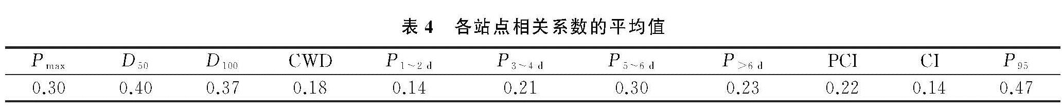
表2中的降维结果反映了研究区不同类型降水指数之间存在着一定程度的共线性,指标群过于冗繁,因此简化并筛选出关键指标更有利于精准评估研究区雨灾的时空变化。表4—5中通过相关分析汇总了各站点某个降水指数与全省水灾受灾面积年际变化的同步性,相关性越高,同步性越强,则该指数越能表征研究区的雨灾变化。可以发现无论是比较相关系数的均值还是呈显著正相关性站点的数量,极端雨天总降水量(P95)明显优于其他降水指数,其对指示研究区水灾具有极强的普适性,应作为表征雨涝灾害的关键指标加以深入分析和探讨。
2.3 关键指标P95的时空演变
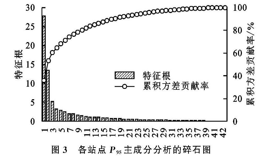
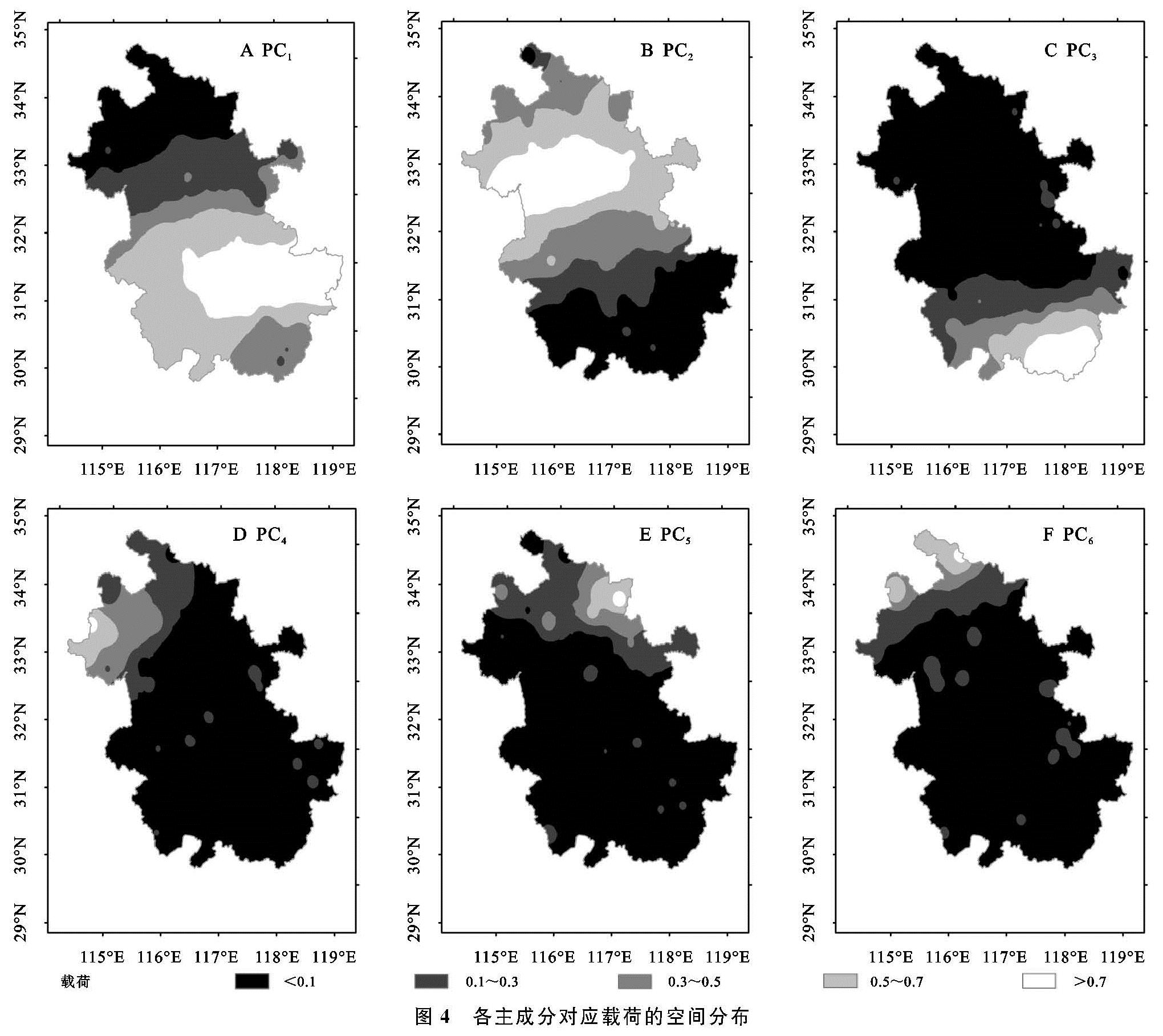
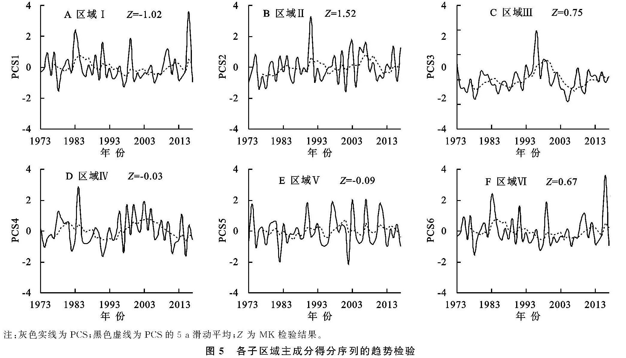
为了辨识关键指标P95年际变化的空间差异,将各站点P95逐年序列构建的77列(77个站点)×45行(45 a)的矩阵导入统计软件SPSS 19.0中进行主成分分析。图3中前6个主成分累积方差贡献率超过了70%,且各主成分的特征根均大于2。因此,77个站点的P95年际变化可识别出6个典型模态,D特别是前3个主成分代表了研究区最突出的3种P95变化型。图4中的载荷表征了不同模态与各站点P95序列的相关性,可有效的将研究区划分为与6个主成分相对应的子区域,分别为区域I(中南部),区域Ⅱ(中北部),区域Ⅲ(南部),区域Ⅳ(西北角),区域V(东北角),区域Ⅵ(最北端)。分区结果与安徽省主要自然地形区的分布较吻合,特别是区域I、区域Ⅱ、区域Ⅲ大致对应了沿江低地区、江淮隆丘区和皖南山区3个典型地形区,这进一步说明了复杂多样的地形地貌以及南北气候过渡性是造成研究区强降水变化区域差异的主要原因[6]。
图5中主成分得分序列直观地表征了各子区域近45 a的P95演变过程。从M-K检验结果来看,各序列1973—2017年的变化趋势均没有通过显著性检验,其中区域Ⅱ的P95上升趋势较强,而区域I的P95下降趋势较强。此外,各序列的五年滑动平均进一步刻画出了P95的波动与振荡。由图5所示,区域I,Ⅱ,Ⅲ,Ⅳ,Ⅵ的P95有着较明显的年代际转折,分别呈现出↑↓↑,↑↓↑,↑↓↑,↑↓↑↓,↑↓↑↓的变化型,而区域Ⅴ的P95则呈现出较强烈的年际波动。值关注的是2003年以后区域I,Ⅲ的P95上升态势显著,而区域Ⅱ的P95在2010年后也呈现出较强的上升态势。东亚夏季风的年代际振荡可能是造成安徽省大部分地区近十几年来强降水增加的主要原因[19]。1990年代末以来,随着东亚夏季风的增强,雨带开始向北移动至长江以北地区,雨带北界超过35°N,进而导致江淮流域夏季降水偏多[20]。
2.4 粮食产量波动对P95的响应
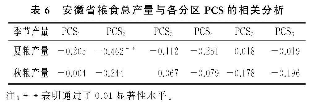
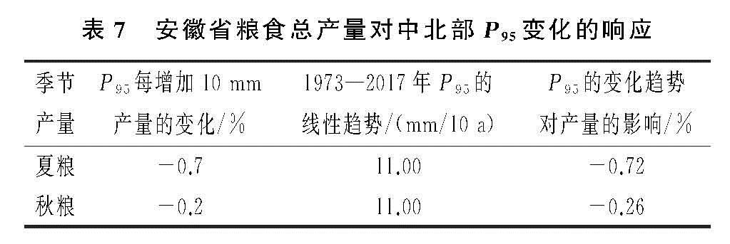
在一阶差分预处理的基础上,计算了全省粮食总产量序列和各子区域P95主成分得分序列的相关系数,以此来探求不同区域强降水变化对粮食生产安全的可能影响。由表6—7可以看出,PCS2与产量的相关性明显高于其他分区,特别是PCS2与夏粮产量呈现出极显著的负相关性,这表明安徽省中北部区域P95的年际变化对粮食产量波动有着显著的指示作用。P95每增加10 mm,夏粮及秋粮的总产量随之减少0.7%和0.2%。由表4还可以发现近45 a安徽中北部P95的增加趋势导致了夏粮及秋粮的总产量分别减产了0.72%和0.26%。总体而言,安徽省强降水的年际变化对粮食生产是不利的,应加强重点区域P95的监测及预报,以降低雨涝灾害导致的粮食损失。