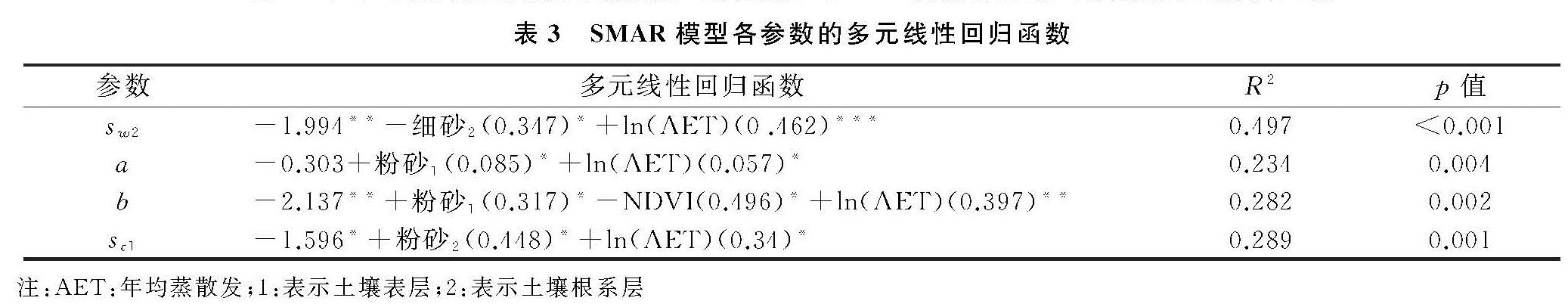
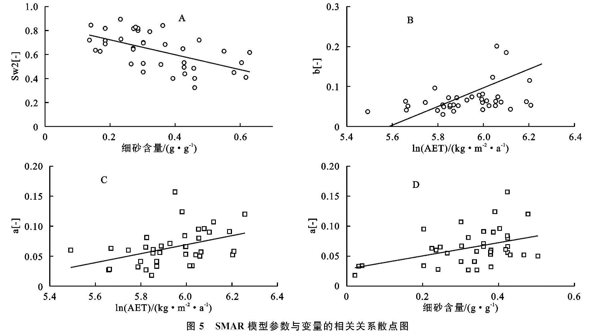
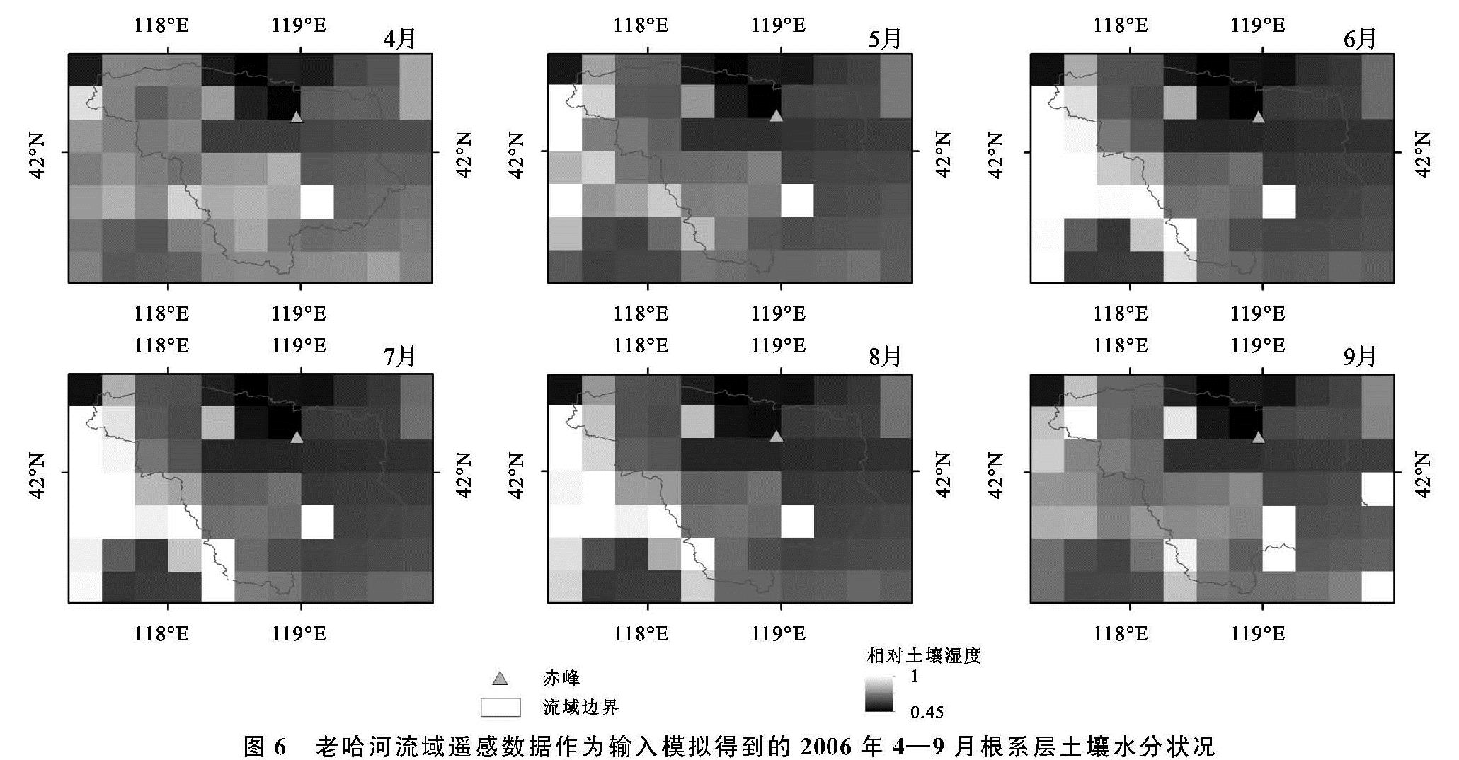
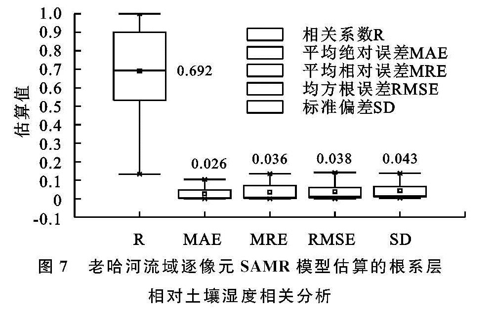
本文目标是获得研究区长时间序列根系层土壤湿度的空间分布。首先采用CDF匹配方法以农气站实测数据为基准对CCI土壤湿度产品进行校正,以支持基于物理基础的SMAR模型。其次以中国300~500 mm等降雨量线内的部分农气站实测的土壤表层SM作为SMAR模型的输入,将实测根系层相对SM与模型模拟的根系层相对SM的RMSE最小作为目标函数,利用MATLAB的遗传算法工具箱进行模型参数优化,得到每个站点最优的参数组合。然后采用多元统计回归分析法结合土壤物理性质、NDVI以及年均ET建立估算SMAR参数的多元线性回归模型。最后以校正后的CCI土壤湿度作为模型输入数据,运用SMAR模型估算研究区逐像元根系层的土壤相对湿度。
2.1 CDF匹配
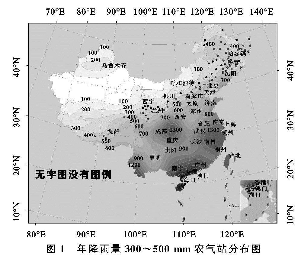
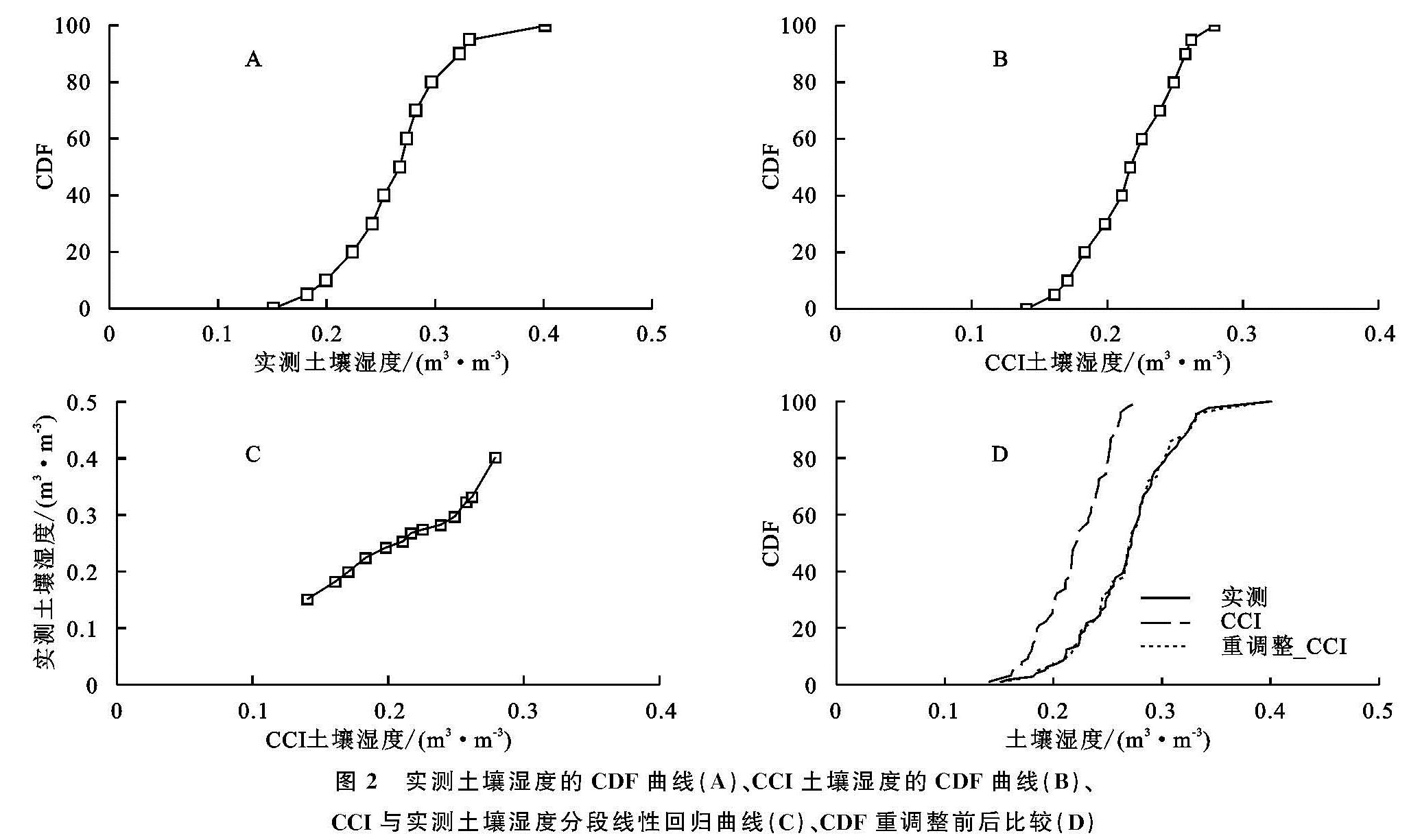
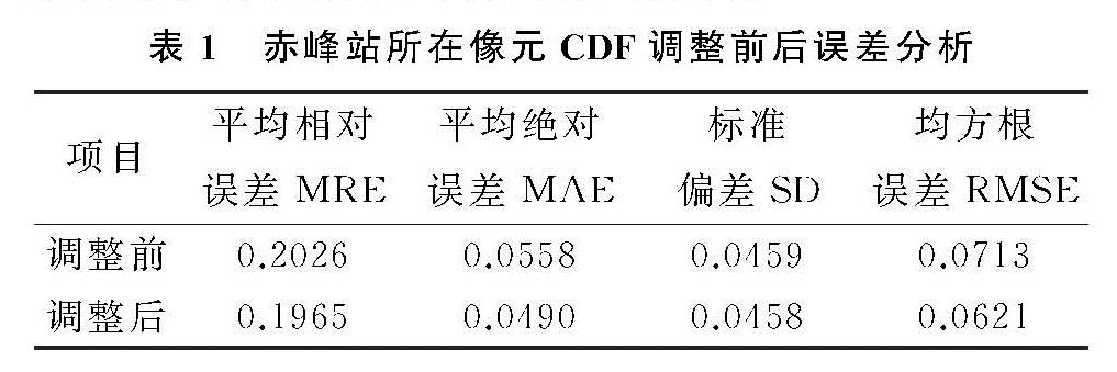
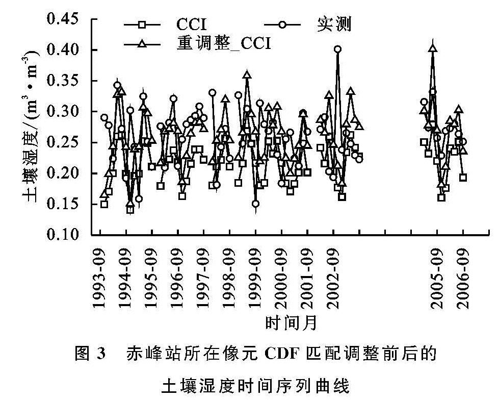
由于遥感获取的CCI土壤湿度产品和农气站实测的地表土壤湿度数据存在系统误差,导致这两组数据存在不一致性,因此为了使遥感数据与农气站实测数据更好地匹配,采用累积概率分布函数(CDF)[16]重调整方法,基于实测土壤湿度数据对遥感数据进行标准化,使其具有相同的取值范围和累积概率分布特征。CDF重调整过程是以像元点为基础进行时间序列统计并调整。在实践中,农气站的分布数量有限,且不均匀,因此需要通过对站点数据进行空间插值获取所研究区域SM的整体时空分布状况。本文选择老哈河流域周围的赤峰等8个站点的1993—2006年4—9月的有效数据进行克里金空间插值[16],以此获得老哈河流域表层实测SM的时空分布,再在此基础上利用CDF匹配技术将CCI土壤湿度产品按照与实测数据相同的时间序列进行重调整,建立研究区逐像元的CCI土壤湿度产品的改进模型。
CDF匹配技术[20]是基于分段线性匹配,研究中,调整后的土壤湿度表达式如下:
CDFsite(x')=CDFCCI(x)(1)
式中:CDFsite和CDFCCI分别表示站点和CCI土壤湿度的累积分布函数; x表示调整之前的CCI土壤湿度。
2.2 SMAR模型
Manfreda等[1]假定土壤由两层组成,第一层是几厘米深的表层(合理的假设是卫星传感器观测深度可以代表5—10 cm的表层动态),而第二层位于第一层之下,延伸到相当于植被的生根深度。两层土壤最重要的水分交换是入渗,横向流动和毛细管上升等过程则可以忽略不计[14]。Manfreda等[1]定义了一个土壤水分平衡方程,它是由半干旱环境中一个简化的土壤水分平衡方程推导出来的,在这个方程中入渗期不是表示为降雨的函数,而是表层中土壤含水量的函数,分别用“1”和“2”区分上下层的变量和参数。只有当土壤水分超过田间持水量时,表层的水分通量才能被认为是显著的。他们提出了描述从顶层到下层的瞬时入渗通量的方程:
n1Zr1y(t)=n1Zr1y(s1(t),t)=n1Zr1{(s1(t)-sc1),s1(t)sc1
0,s1(t)<sc1(2)
式中: y(t)[-]表示下层土壤饱和渗透分数; n1[-]表示第一层土壤孔隙度; Zr1表示第一层土层深度; s1((θ1)/(n1))[-]表示第一层的相对饱和度(它是由第一层土壤体积含水量与土壤孔隙度的比值决定的); sc1[-]表示第一层田间含水量相对饱和值。此公式意味着当相对饱和度高于田间含水量的任何值时,土壤的渗透性是无限大的,该模型不考虑下层的饱和效应。
第二层和深层土壤水分平衡受入渗和水土流失两个因素控制,水土流失主要又包括蒸发蒸腾损失和渗透。定义土壤第二层的“有效”土壤相对饱和度为:
x2=(s2-sw2)/(1-sw2)(3)
土壤贮水量为:
ω0=(1-sw2)n2Zr2(4)
则土壤水分平衡可以用式(5)来表述:
(1-sw2)n2Zr2(dx2(t))/(dt)=n1Zr1y(t)-V2x2(t)(5)
式中: s2[-]表示第二层的相对饱和度; sw2[-]表示凋萎点的相对饱和度; n2[-]表示第二层的土壤孔隙度; Zr2[L]表示第二层的土层深度; V2[LT-1]表示蒸散和渗透损失的土壤水分损失系数; x2[-]表示第二层土壤的“有效”相对饱和度。此方程不考虑土壤水分高值时土壤流失函数的高度非线性,这种简化,再加上渗透不考虑饱和效应,意味该方法在潮湿环境中有一定的局限性,更适用于干旱半干旱环境。
上述方程可以用归一化系数和简化为:
a=(V2)/((1-sw2)n2Zr2)
b=(n1Zr1)/((1-sw2)n2Zr2)(6)
“扩散系数”是土壤表层总可能储水量(n1Zr1)与总根区储水量((1-sw2)n2Zr2)之比确定,“水分流失系数”控制根系层水分损失,是蒸散发ET与排水损失之和与总根区储水量之比确定,这些参数的取值可直接与两土层的深度和水土流失系数之比有关。因此,土壤水分平衡方程即为式(7):
(dx2(t))/(dt)=by(t)-ax2(t)(7)
假设相对饱和度x2(t)初始条件等于0,可以推导出这种线性微分方程的解析解:
x2(t)=∫t0bea(ω-t)y(ω)dω(8)
在实际具体应用中,可能还需要离散的形式见公式(9):
x2(tj)=∑ji=0bea(ti-tj)y(ti)Δt(9)
扩展式中,假设Δt=(tj-t(j-1)),根据表层土壤湿度的时间序列可以推导出下层土壤湿度的公式(10):
x2(tj)=x2(tj-1)e-a(tj-tj-1)+by(tj)(tj-tj-1)(10)
也可以写成s2的函数:
s2(tj)=[sw2+(s2(tj-1)-sw2)e-a(tj-tj-1)]+[(1-sw2)by(tj)(tj-tj-1)](11)
式中:左半部分计算给定的时间步长中相对水分损失,水分损失函数随s2线性减小,直至达到sw2,此时水分损失为零,蒸散和排水损失假定在凋萎点值或以下可忽略不计,右半部分表示从表面到根区扩散的水分含量。Manfreda等[1]提出的方法是一种代表了两个状态变量之间土壤水分分析关系式,需要确定的4个参数分别是:sw2,a,b,sc1,所有参数均可从土壤质地分数、土层深度和土壤水分损失等估计。
2.3 遗传算法
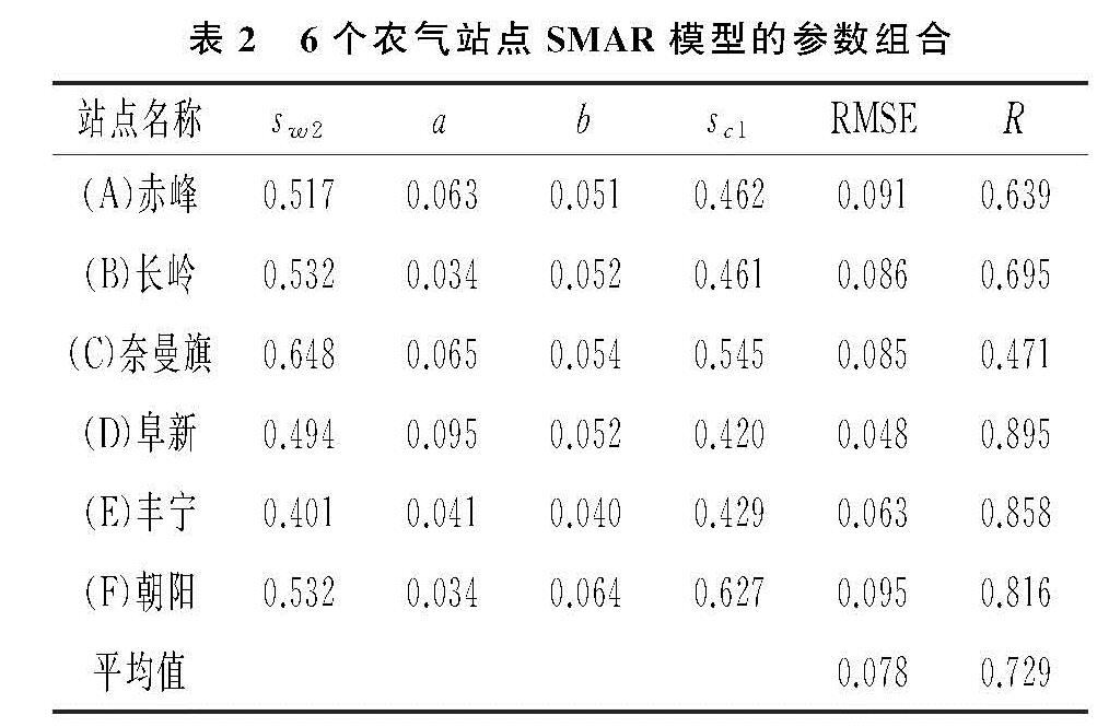
为了分别得到最优的模型参数组合,本文使用MATLAB的遗传算法工具箱GUI进行模型参数的优化估计[14,21]。MATLAB遗传算法工具,即图形用户界面GUI,它使我们可以使用遗传算法而不用命令行的方式。遗传算法[22]是一种基于自然选择、生物进化过程来求解问题的方法。在每一步中,遗传算法随机地从当前种群中选择若干个体作为父辈,并且使用它们产生下一代的子种群。在连续若干代后,种群朝着优化解的方向进化,最终得到最优解组合。本文以各站点表层SM数据模拟得到的根系层相对SM与农气站实际测量得到的根系层相对SM均值之间的RMSE最小为优化准则进行优化处理,假设每个参数的上、下边界分别相当于最大和最小可能值(例如,0≤sc1≤1)。参数估计时,第二层土壤相对饱和度s2初始值设置为各农气站实测的逐旬田间持水量相对饱和值的均值。应该注意的是,SMAR模型可能产生高于1的值,这些值需自动设置为1。