3.1 流域降雨量的基本特征
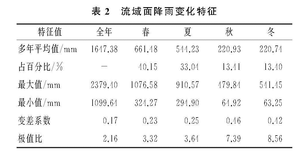
贡水流域属中亚热带湿润季风气候区,雨量充沛,四季分明。流域的多年平均降雨达1 647.38 mm,最大为2016年(2 379.40 mm),最小为2003年(1 099.64 mm)(表2)。在1957—2016年,总体年际变化较为稳定,变差系数仅为0.17。春季降雨最多,占全年降雨的40.15%; 夏季暴雨集中,降雨占全年的33.04%; 秋、冬两季降雨量较少,仅占全年降雨量的13.41%和13.40%。降雨量越少,变差系数越大。春、夏两季变差系数分别为0.23,0.25,而秋、冬季变差系数分别为0.46,0.42。与降雨量相反,降雨极值比在冬季最大,春季最小。
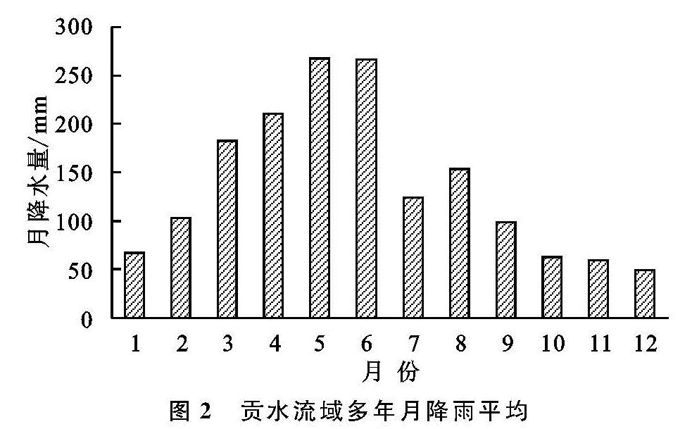
降雨年内分配不均,降雨呈双峰型(图2),其中降雨最大月出现在5月、6月,多年平均月降雨量约为267 mm,5月、6月累计降雨占全年降雨量的32%; 流域内的4—9月为汛期,汛期累计降雨占全年的68.96%; 降雨最少的月份为12月,月平均降雨量仅为49.65 mm,占全年的3.00%。流域降雨特征决定了流域春、夏多洪涝,秋、冬易遭旱灾的特点。
3.2 雨量变化趋势及周期
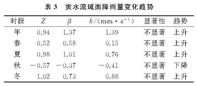
对1957—2016年贡水流域年、季雨量序列,分别采用M-K趋势检验、Sen's斜率估计和线性回归对流域各时段的降雨趋势进行计算,并取95%置信度进行显著性检验(表3)。结果表明:贡水流域在近60 a内的年际及春、夏、冬季降雨量总体呈上升趋势,但上升趋势不显著,未通过显著性检验,秋季的降雨量呈下降趋势。如按此趋势,该流域未来夏涝秋旱的问题将更为严重,应予以重视。
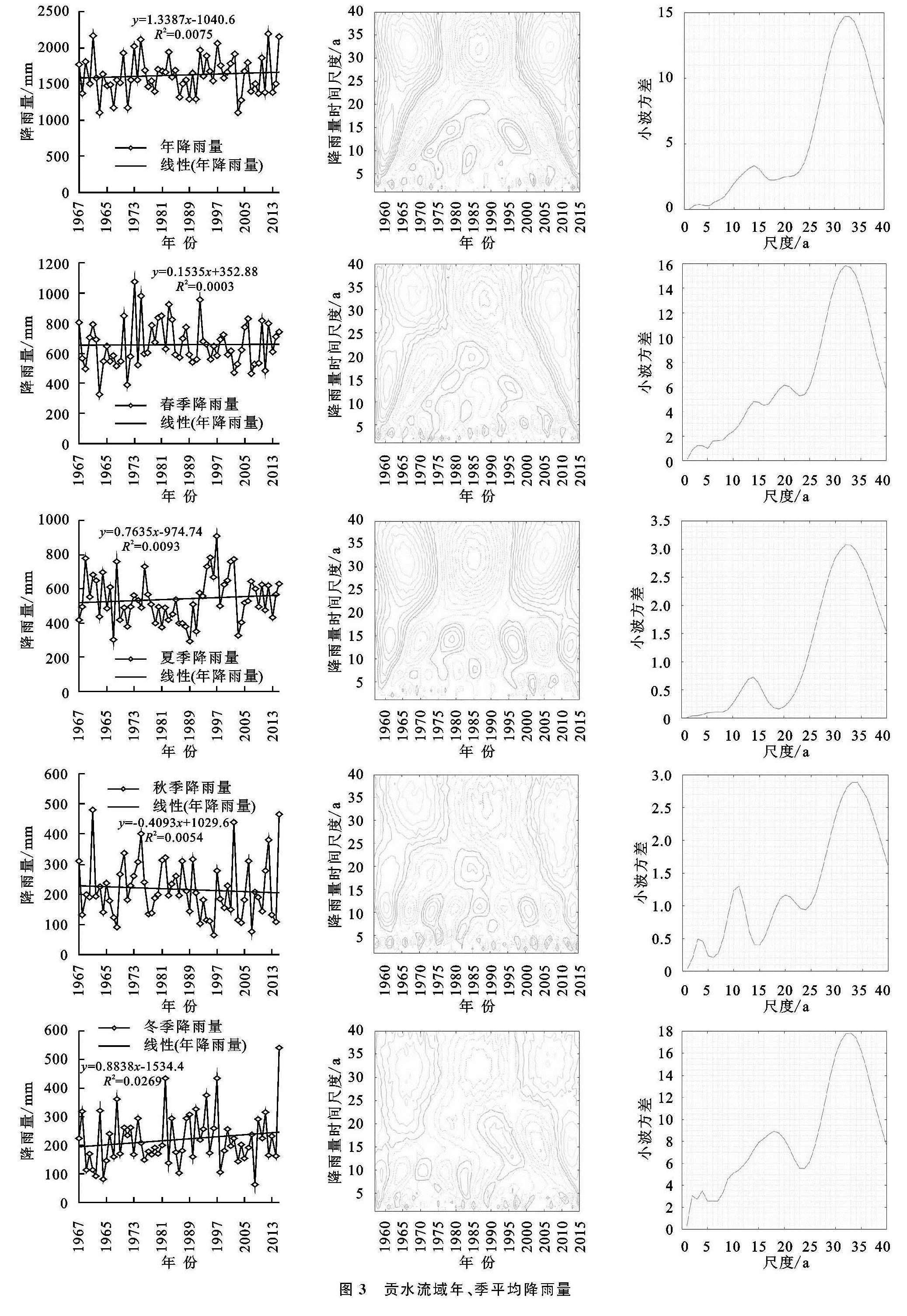
小波系数等值线图反映了降雨量序列不同时间尺度的周期变化及其时间分布,从而推断不同时间尺度下降雨量的变化趋势; 小波方差图反映了能量随时间尺度的分布,可以确定一个时间序列受到各种尺度扰动相对强度,对应峰值处的尺度称为序列的主要时间尺度,用以反映时间序列的主要周期[17]。以贡水流域1957—2016年数据为基础,绘制贡水流域年、季小波系数等值线图和小波方差图(图3)。
从年际来看,在年降雨量小波系数等值线图中存在2类尺度的周期变化,在30~35 a时间尺度上,经历“多—少—多”震荡; 在10~15 a时间尺度上表现为明显的7次“多—少”循环交替。在小波方差图中存在2个明显的峰值,其最高峰对应着32 a的时间尺度,表示32 a左右的周期震荡最强,为第一主周期; 另一峰值对应的14 a时间尺度,为第二主周期。
从季节来看,各季的周期各不相同。春季降雨量存在2类时间尺度的周期变化,在30~35 a时间尺度上具有3次“多—少”周期震荡; 在10~20 a出现7次“多—少”循环交替; 在小波方差图中呈现3处峰值,分别对应32,20,14 a的时间尺度,其中32 a为春季降雨量变化的第一主周期,20 a次之,14 a为第三主周期。夏季降雨量在小波系数等值线图和方差图中变现与年降雨量一致。秋季降雨量的变化最为复杂,存在4类时间尺度的周期变化,分别为30~35,18~22,10~15,3~5 a,其分别对应的“多—少”周期震荡为4次、5次、9次、22次,34 a,11 a,20 a,3 a分别为第一、二、三、四主周期。冬季小波系数等值线图上存在3类时间尺度,在30~35 a时间尺度上出现3次“多—少”周期震荡,在15~20 a上存在少—多循环交替6次,在3~5 a上具有20次“多—少”周期震荡; 方差图上呈现3处峰值,按峰值大小排序,对应时间尺度为34,18,4 a,分别为第一主周期、第二主周期、第三主周期。
综合可得,贡水流域春季、夏季降雨和年降雨变化趋势具有较大相似性,不同时间尺度的周期特征之间有不同程度的吻合,说明春、夏季降雨较大程度地控制着年降雨过程,与前文所提春夏两季降雨占全年比重大的结论吻合。
3.3 降雨量突变分析
从年内来看,对比Pettitt法和累积距平法的检验结果(图4),春季、夏季、秋季分别在1927年、1991年、1987年发生了降雨量增加突变,并且夏季的突变点通过了α=0.05的显著性检验; 秋季及年际降雨量在1991年发生减少突变;
分析可得,在近60 a间贡水流域在60年代降雨量在年、春、秋、冬都呈现下降趋势,调查发现在该年代发生了两次重大干旱灾害,分别为1963年和1967年。在2010年后降雨量在不同时间指标上,都呈现增加势态。流域年、季降水量总体表现为增加趋势,变化呈波动性。
3.4 流域雨量的空间分布
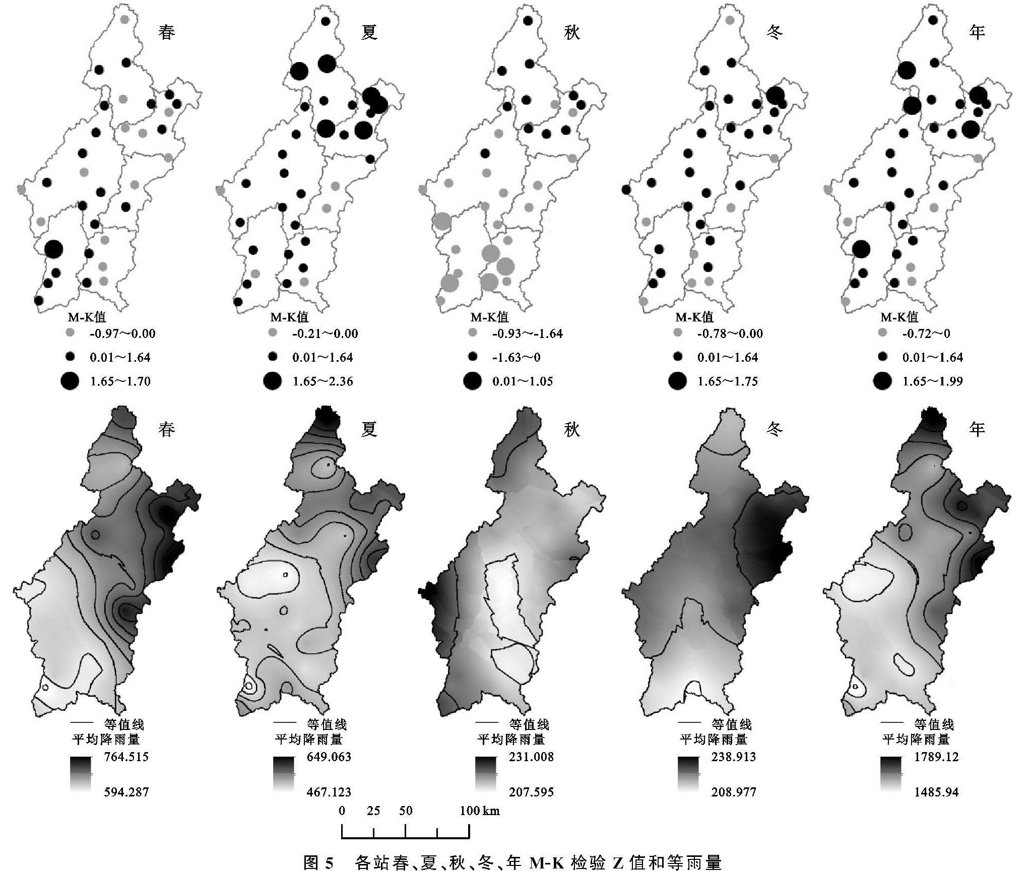
为了研究雨量在不同站点的空间分布,对全流域33个雨量站进行M-K趋势检验(图5)。
从全年来看,仅有7个站点呈现不显著的下降趋势,站点降雨趋势总体与前文的流域平均面雨量变化的趋势保持一致。
从年内各季来看,春、夏、秋、冬四季各站的雨量变化趋势总体上是符合各季流域平均面雨量变化趋势的,即上升、上升、下降、上升; 春季呈现较显著(α=0.1)变化的有1站,夏季6站,秋季5站,冬季1站,其中夏季有1站(木兰)呈现显著(α=0.05)变化趋势。
图5可知,春夏两季的各站间的点降雨量差距大,极值差分别为170.49 mm,191.47 mm,秋冬两季的各站差距较小,极值差分别为52.99 mm,56.10 mm。除秋、冬季外,空间上,降雨量总体分布特征为自东向西减少,自北向南减少。
结合各站趋势统计和等雨量图分析季节降雨量分布特征如下:
春季:春季各区总体处于上升趋势,降雨量最多的区域为梅江、琴江和绵江流域,其中以琴江和绵江流域上游等地降雨量尤为偏多。
夏季:夏季各区降雨趋势依旧为上升趋势,但是降雨量相对春季偏少,降雨量最大地区开始出现往北移动的趋势,降雨量最多区域为在梅江流域,琴江上游地区降雨量的上升趋势显著。
秋季:秋季各区降雨分布自东向西增多,降水大致呈现出下降趋势,部分呈微弱上升,主要集中在梅江、琴江流域等北部地区,而濂水、湘水流域等南部地区呈显著下降趋势。
冬季:冬季各区的降雨量分布较为均匀,中部地区相对偏多,降雨趋势总体呈现为缓慢上升,与秋季不同。
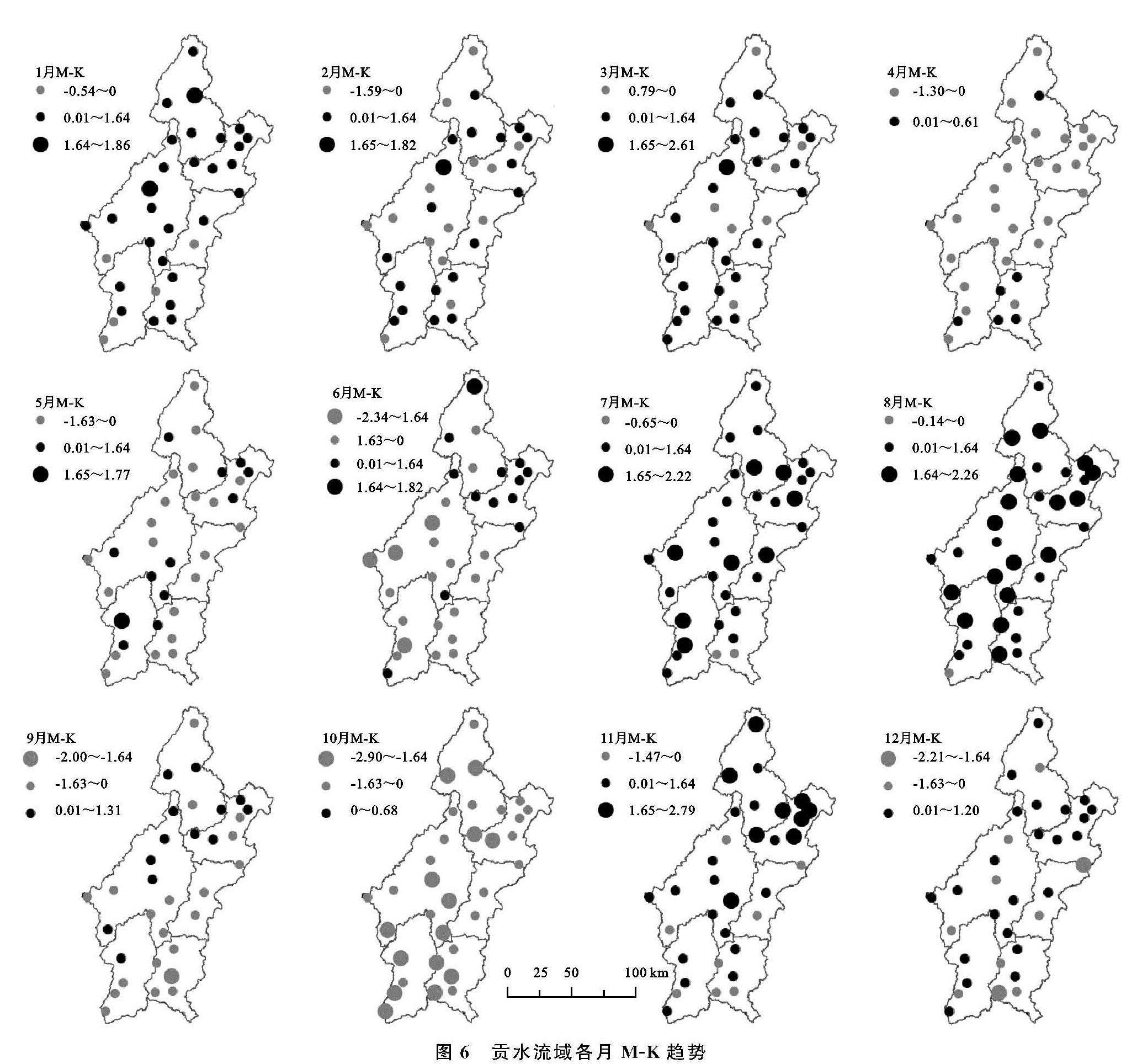
从年内各月来看,其变化趋势各有不同,将各站各月的M-K趋势检验的结果绘图,见图6。1月、3月、9月、12月的贡水流域总体呈现上升趋势,流域内各站的上升趋势较为均匀,出现下降趋势的主要集中在濂水、湘水、贡水干流区等流域较南部区域; 7月、8月、11月的流域内上升趋势分布不均匀,从东北向西南递减,其中8月份的降水显著上升,具有显著性上升趋势的站点达到9站,主要分布在梅江、琴江流域; 2月、5月流域内降水趋势分布较为均匀,没有表现出较大的地区流域差异; 4月、6月、10月流域总体呈下降趋势,在空间分布上从东北向西南降水减小趋势越来越明显,尤其以10月份为甚,具有显著性下降的站点达到7处,且这些站点基本分布在濂水和湘水等流域。
图5 各站春、夏、秋、冬、年M-K检验Z值和等雨量
3.5 贡水流域暴雨时空特征分析
本文暴雨泛指日降水量≥50 mm的降水过程,主要从时间和空间上研究暴雨的分布特性。
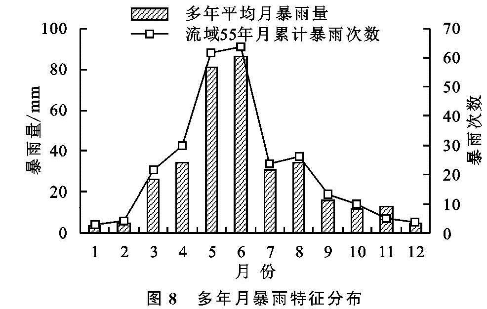
时间上,全年暴雨呈双峰状,与流域多年月降雨量线型走势大致相同(图7)。
暴雨发生频率与暴雨量分布基本统一,暴雨集中发生在每年的5月、6月,其暴雨量占到全年暴雨量的48.42%,发生暴雨的频率达到47.28%; 1月、2月、12月暴雨量几乎为零,发生频率仅为4.15%,见图8。
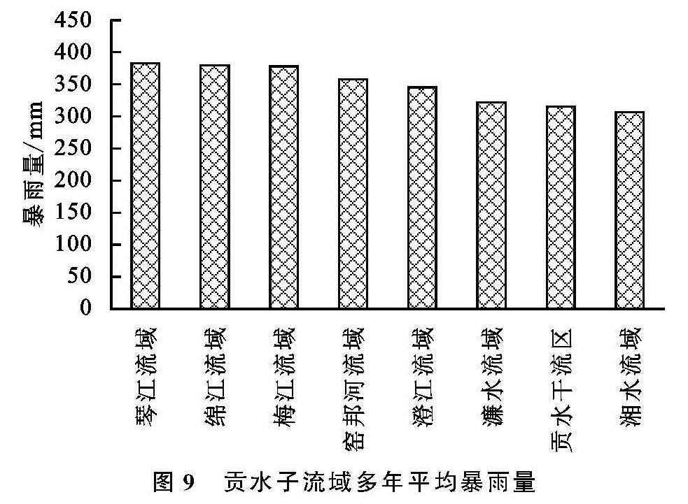
为了更好的表现暴雨的空间分布特征,以贡水流域内的子流域进行面暴雨计算(图9)。暴雨多年均值最大为琴江流域的383.41 mm,最小为湘水流域的306.94 mm,结合流域内子流域的分布图,可以发现暴雨年均值自北向南、自东向西递减,与3.4节中流域雨量空间分布结论一致。
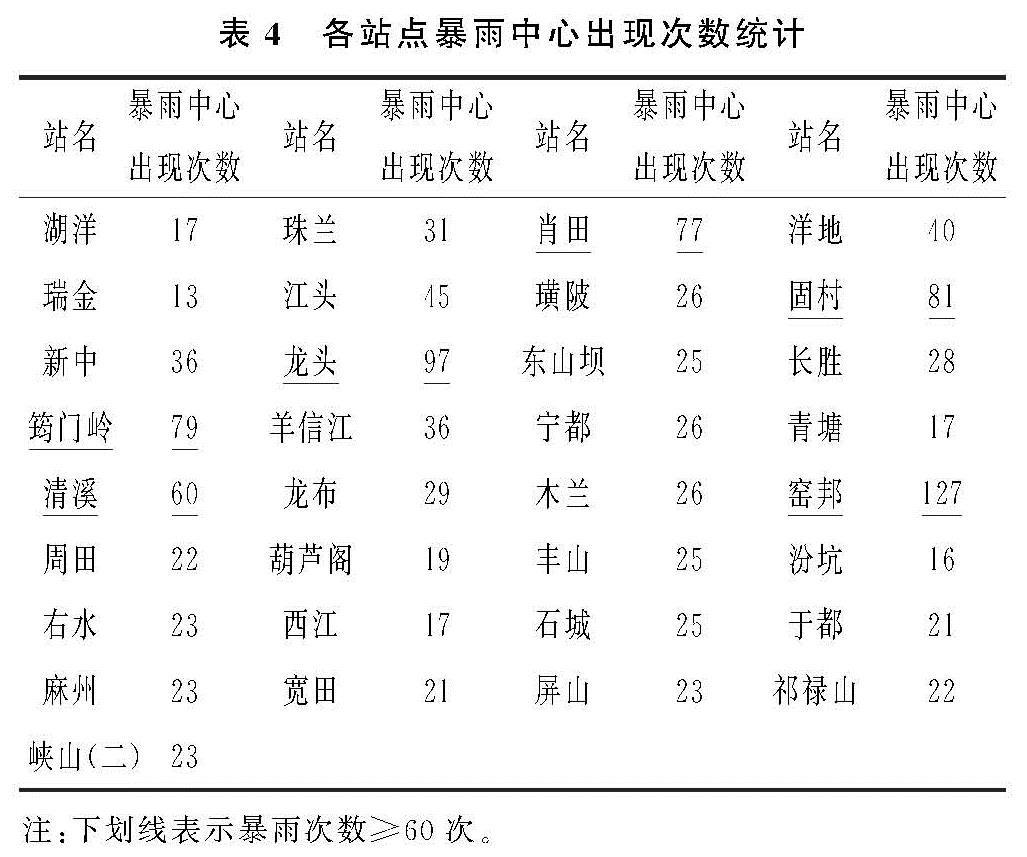
暴雨中心定义为每次暴雨发生时暴雨量最大值出现的点,以各雨量站点为单位进行点暴雨计算。为了保证研究结果的科学性,规避原始数据缺失带来的影响,选取1970—1995年资料完整的33个雨量站,统计每个站点在26 a间成为暴雨中心的次数(表4)。
从表中可以看出在1970—1995年,窑邦、龙头、固村、筠门岭、肖田、清溪成为暴雨中心的次数≥60次。然龙头、筠门岭、清溪分属于濂水、湘水流域,为暴雨量及降雨量较小的流域,尤其是龙头地区,降雨量为全流域最少,说明该地区降雨以短时强暴雨为主,极易爆发山洪; 其他站点暴雨中心出现频次与暴雨量及降雨量分布吻合,是洪涝灾害发生的高频地区。