3.1 土壤颗粒分形维数与土壤机械组成的关系
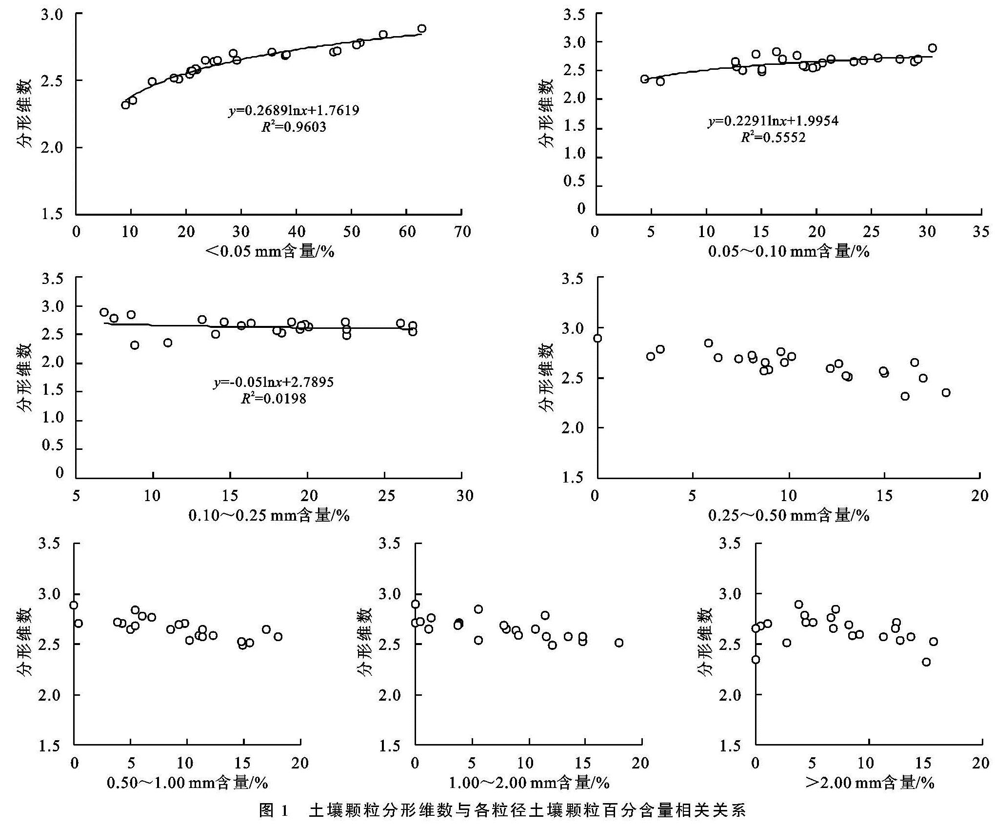
土壤颗粒机械组成与分形维数的关系,不仅与其成土母质、土壤质地、物理化学风化过程等有关,不同植被类型、土地利用方式对土壤颗粒分形维数也存在一定影响[26-27]。通过土壤颗粒分形维数与各粒径土壤颗粒百分含量相关性分析与回归分析(图1)可知,研究区土壤颗粒分形维数D值与粉砂、极细砂的百分含量呈极显著正相关关系(p<0.01),其中土壤颗粒分形维数与粉砂的百分含量之间相关系数最大,为0.960。与细砂的百分含量呈负相关关系,相关系数为-0.020,与中砂、粗砂和极粗砂的百分含量的相关关系不显著。这表明粉砂、极细砂含量越高,土壤颗粒的分形维数值越大,反之越小。这一研究结果与众多研究土壤分形维数与粉砂含量关系的结果相一致[28],而与部分研究关于土壤分形维数与粉砂关系的结果有所不同[29]。根据土壤颗粒分形维数计算过程得知,分形维数在6种不同群落的线性拟合分析方程的R2为0.019 8~0.960 3,说明分形维数拟合效果能反映土壤粒径分布情况。根据学者对土壤细颗粒含量与土壤退化的关系的研究,结合本研究土壤颗粒分形维数与土壤颗粒机械组成之间相关性,也能说明土壤颗粒分形维数可作为指示土壤退化的一个重要指标。
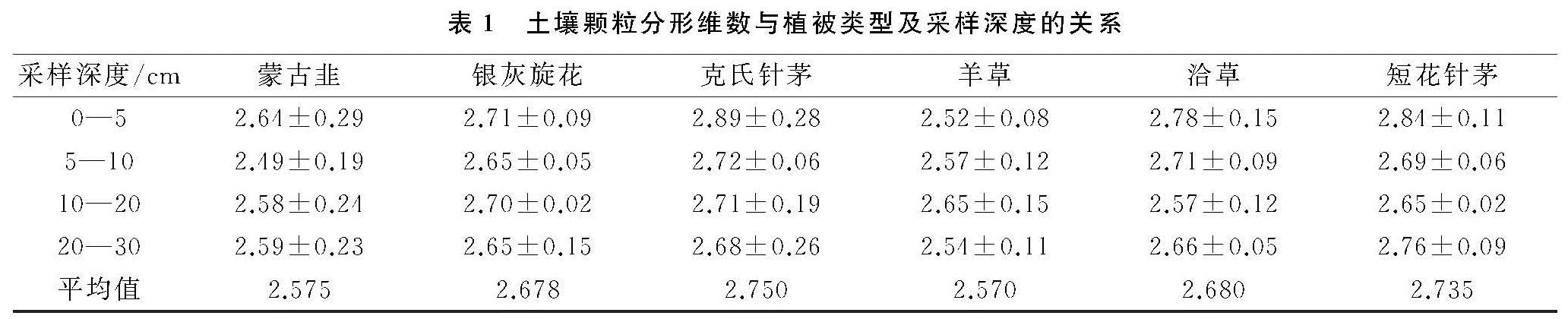
另外6种不同群落的土壤分形维数随采样深度增加呈现不同程度的波动,整体呈线性下降趋势,原因是由于该样地在实施封育措施后,易形成良好的土壤结构,植被恢复程度逐年加大,植被盖度也随之增加,地表土壤细粒物质逐渐增多,对应的土壤分形维数有增大趋势,在0—10 cm土层中改善作用较明显。另一原因由于草地上80%以上生长的是草本植物,其根系主要分布在相对较浅的土层中,由于植物根系能够有效的增加下层土壤团聚体的含量,使土壤分形维数相应减小。本研究对6种不同群落土壤颗粒分形维数计算发现,希拉穆仁天然草地不同群落类型下土壤颗粒分形维数为2.518~2.780,平均值2.649,说明研究区土壤质地比较均一。根据刘云鹏采用分形模型研究表明
[30],分形维数应在2.75左右土壤其粒径结构较良好。进一步分析发现克氏针茅、短花针茅群落土壤分形维数最接近2.75,说明该群落样地土壤结构状况最好,能够较好的保肥保水。而蒙古韭、银灰旋花、羊草群落分形维数较低,土壤结构较差,这一规律与植被盖度高和枯枝落叶层较厚易增加地表土壤养分含量和粉黏粒含量有一定关系。
3.2 土壤颗粒分形维数与土壤物理参数的关系
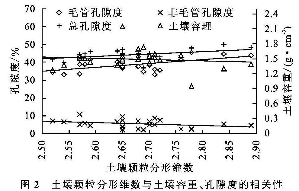
结构较为良好的土壤容重通常为1.25~1.35 g/cm3,相应的土壤总孔隙度一般为40%~50%[31]。该地区土壤容重在1.28~2.14 g/cm3,总孔隙度为34.63%~50.17%。一般来讲,土壤颗粒分形维数越高,土壤质地细颗粒物质越多,通透性越差,分形维数值越低,则土壤结构越松散[32]。但在近自然恢复状态下围封的荒漠草原区域内呈现相反的规律,土壤颗粒分形维数与总孔隙度、毛管孔隙度呈显著正相关,与土壤容重呈负相关,与非毛管孔隙度相关性不显著。表明围封区内,土壤孔隙度越大,通气透水性能越好,对应分形维数越高,规律不一致主要与该地区土壤中粗颗粒物质较细颗粒物质相对较高、分形维数总体相对较低有关,即土壤颗粒分形维数随土壤颗粒机械组成、粒径含量的不同与土壤的松散程度、通气性表现出阈值效应[25]。
3.3 土壤颗粒分形维数与土壤蓄水性能的关系
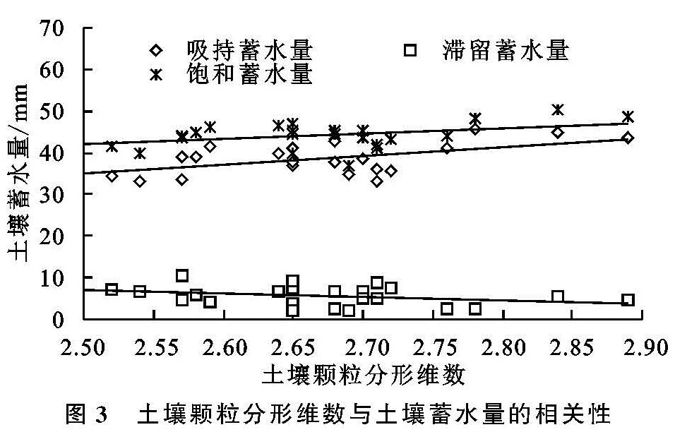
土壤颗粒分形维数在某种程度上可以表明土壤的蓄水性能,其中饱和蓄水量为吸持蓄水量和滞留蓄水量的总和,可以较好地反映植被减少地表径流和防止土壤发生侵蚀的功能,而吸持蓄水量又称为毛管持水量,滞留蓄水程为非毛管蓄水,主要反映植被的水源涵养功能[24-25]。土壤蓄水性能的差异主要与土壤孔隙的大小有关,近自然恢复状态下荒漠草原的土壤颗粒分形维数与饱和蓄水量、吸持蓄水量呈显著正相关(p<0.01),与滞留蓄水量相关性不显著。表明群落类型不同,土壤颗粒分形维数对土壤蓄水性能表现出一定的差异。土壤颗粒中粉砂、极细砂含量越高的分形维数相对较高,粉砂、极细砂含量高的土壤在改善土壤通气、透水性能的同时,增强土壤毛管孔隙度利于土壤团聚体的形成,提高水分子的吸附力,进而增强土壤的持水性能。从土壤颗粒分形及其蓄水性能特征来看,该地区6种群落改良土壤特性及蓄水功能表现为克氏针茅、短花针茅和洽草群落优于其他3种群落。