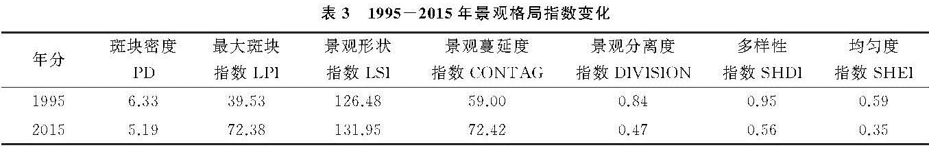
土壤侵蚀是指土壤及其母质受风蚀和水蚀等外部作用力的影响,发生剥蚀分离、输移和沉积的生态水文过程[1]。该过程中挟带的大量泥沙及营养物质(N,P,K等),造成农用地退化的同时,往往导致下游水体河床升高、湖泊富营养化等,威胁河流生态功能安全[2]。研究表明,造成土壤侵蚀的原因有:非合理耕种、过度开发等人类活动因素,以及土壤退化、高强度降水、植被覆盖度降低等自然因素。其中,土地利用带来的区域景观格局变化是近年来影响土壤侵蚀的主因[3]。例如,康磊等[4]在岷江上游发现以草地恢复为主的景观格局演变,明显降低了该区土壤侵蚀的强度; 潘竟虎等[5]在甘肃泾河小流域的相关研究中表明,坡度>25°且海拔低于1 295 m的景观破碎化程度严重区域,流域侵蚀严重,河流产沙量显著增加。此外,王计平等[6]在黄土丘陵区发现,流域景观格局的变化还会影响局部微气候,进而加重或减轻区域土壤侵蚀程度。因此,明确流域景观格局与土壤侵蚀、泥沙流失过程的关系是景观格局优化的基础,对于水土保持服务有着重要的意义。
近几十年来,遥感(RS)及地理信息系统(GIS)技术发展迅速,推动了景观生态的发展。利用景观格局指数表征格局配置与土壤流失之间的关系,定量土壤侵蚀过程对景观格局变化的响应,是评估生态水文循环的有效手段。基于多年实测气象数据,水文模型能够结合景观格局变化,在大尺度长时间水平上,定量探究流域径流产沙过程对人类活动的响应机制。刘宇[7]利用水文模型WATEM/SEDEM在延河模拟小流域输沙量时发现,在斑块类型尺度上的景观指数对河道侵蚀产沙程度的表征存在一定不确定性。廖凯涛等[8]在江西廉江河流域分析得出,景观多样性程度的加深,可减缓流域侵蚀产沙能力。李晶等[9]在延河流域通过SWAT模型划分出子流域中的水文响应单元,建立了一种新的综合景观指数,发现该指数与产沙量之间耦合关系呈负相关。以上研究将生态水文循环过程与景观格局指数相耦合,可较完善的阐释出过程与格局之间的关系。因此,利用景观格局指数表征流域土壤侵蚀程度,结合水文模型进行定量的分析流域生态水文循环机制,是未来探究趋势[10]。
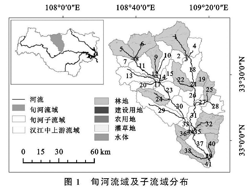
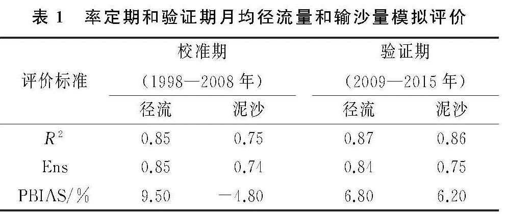
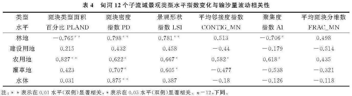
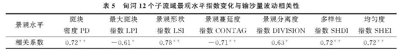
目前,对于土壤侵蚀的研究多是依靠一个或少数几个流域的监测数据进行分析[11-12],很少对流域按照区位划分,进行系统对比研究。对于较大尺度的流域,获取水文泥沙数据尚且困难,在部分小流域的泥沙监测数据更为缺乏。泥沙在河流中的运移机制主要受水量、下垫面和泥沙(属性组成,选择性迁移)等多因素共同影响。利用水文模型能够定量计算子流域输沙量的优势,结合景观格局演变特征,开展多流域多区域的对比,有利于更好的阐述泥沙输移的控制机制。基于此,本研究选取位于“南水北调(中线)工程”水源地—丹江口水库上游的旬河流域为研究区,基于SWAT模型,模拟整体流域及其子流域的输沙量,同时结合景观分析和多元线性回归分析的方法,将模型划分出的子流域分为上、中、下游,选取能够代表该流域实际生态环境情况的景观指数,分析旬河流域各景观格局指数对输沙量的相关性及解释度,探究1995—2015年景观格局的改变对流域输沙量的影响。为该流域土地利用合理规划及水土流失治理措施提供参考意见,提高生态经济效益。