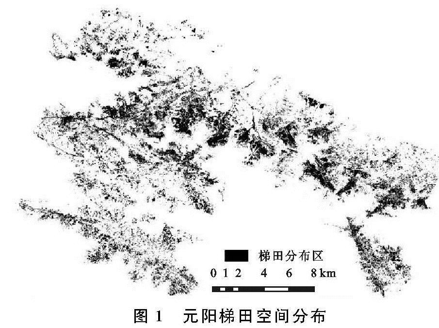
2.1 梯田空间分布
元阳中部是梯田的集中区,也是本研究的重点区域,包括全福庄、坝达、多依树等在内几个大的核心片区(图1); 面积规模大、空间集中连续,边界分明; 东南部、南部、西南部和西北部的其他区域的梯田,面积、规模均不如中部。
在地形上,海拔800~1 500 m的中部亚热带山地季风气候区因地形平缓、水热条件组合好,发育了梯田的72.23%; 中部梯田集中区海拔就位于这一范围内(附图5); 中部区域在片麻岩类母质基础上沿高线修筑了长度不一、拾级而上的层层梯田,面积达246.59 km2,占梯田的58.99%(附图6); 如同细长的银带悬挂在连绵起伏的山体上,受海拔分区影响该区土壤带谱为红壤与黄壤,共分布221.25 km2梯田,占52.93%(附图7),其中中部麻黄红土(红壤)、麻黄赤红土(赤红壤)两个土属,分布了梯田总面积的32.04%。
2.2 梯田的地形分异
作为人工生态系统的一种,水稻的生长发育受自然条件影响显著。高程适中、坡度平缓、坡向适宜的地形最适宜水稻种植,不仅表现在生长上,同时对生产管理、空间布局具有重要意义。
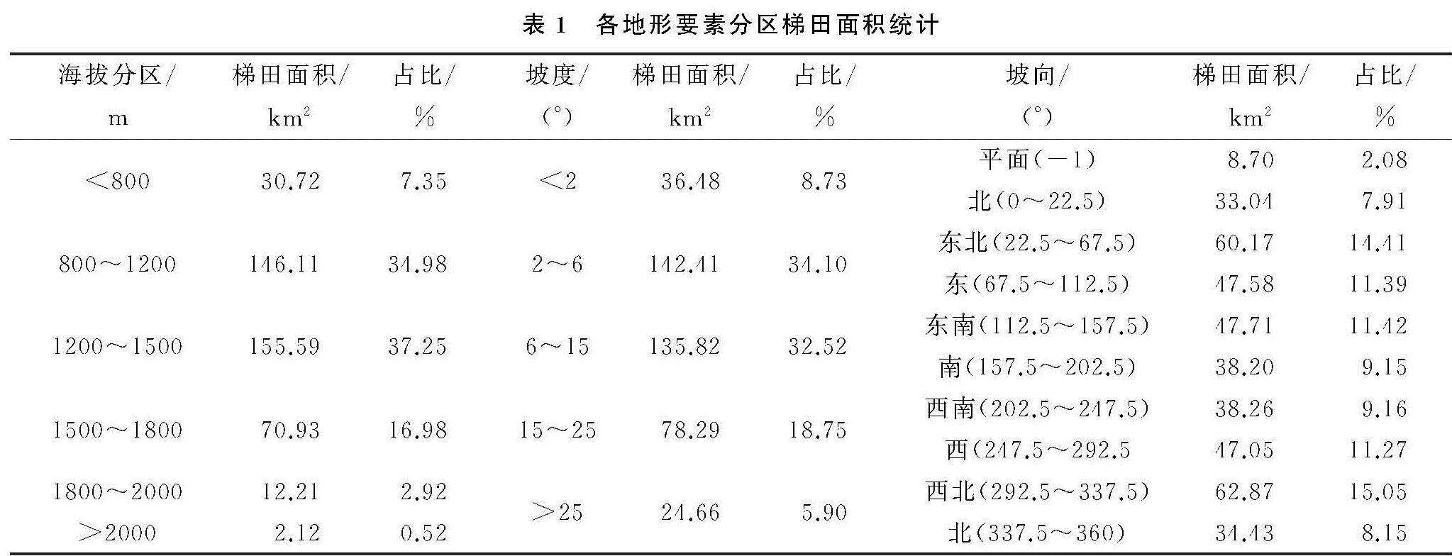
不同海拔接收的太阳辐射、大气降水具有明显差异,进而影响水稻的生长发育和空间分布。适宜的海拔利于梯田的修筑,同时方便生产管理。元阳梯田在空间上呈现出明显的分带性(附图5),海拔800~1 200 m南亚热带中山梯田区(分布34.98%),1 200~1 500 m的中亚热带中山梯田区(占37.25%)以及1 500~1 800 m的北亚热带中山梯田区(16.98%),3个亚热气候带分布了梯田的89.21%(表1),800 m以下的热带河谷区蒸发大而降水少、高于1 800 m的温带山区热量不足,尽管面积广大却只分布梯田的10.79%。
从附图5与表1可以看出,海拔区间800~1 500 m的中部分布了梯田的72.23%。从地貌等级上看,这一海拔区间属于亚热带中山地貌,水汽爬升冷凝极易产生“地形雨”,降水总量、频率明显丰于其他区间,这对需水量大的水稻是一个重要保障。此外,中间海拔区气候适宜,利于农业生产。从海拔140 m的红河谷至2 000 m的观音山上,上千级梯田依山体等高线分布,形成了全世界规模最大、分布最为集中壮观的稻作梯田地理景观。沿等高线修筑梯田是哈尼先民繁衍发展与生存的一个重要保障,逐级抬升不仅提高了太阳辐射面积、充分利用光热资源,而且避免了大面积土方搬运所需的极大投入,同时也降低了因梯田面积过大、田埂过高诱发的垮塌、滑坡几率,以及由此带来维修时的人力、物力以及时间等成本。
坡度的大小直接影响着梯田的形态和面积规模; 同时适宜的坡度亦使含水岩土有着良好的给水性,形成了梯田区广泛出露的地下水,为梯田提供了稳定补给水源。15°内为平耕地、缓坡耕地,分布了梯田的75.35%(表1),中部梯田区在坡度上就处于这一区间,地势起伏平缓、开发条件优越,梯田面积大且集中连续(附图5); 中部以外广大地区因地形起伏跨度大,只是斑块状分布了24.65%的梯田。梯田随山势地形变化,因地制宜,坡缓地大则开垦大田,坡陡地小则开垦小田,甚至在沟边坎下石隙也开田,梯田大者有数亩,小者仅有簸箕大,一坡就有成千上万亩[13]; 依据坡度的大小,设计梯田的宽窄和长度,把高处的土方往低处搬运,台地不人为拉直,而是沿山势自然弯曲伸长[14],最终形成自山脚河谷到山腰宽窄不同、层层叠叠的梯田。这种在原有自然基础上依坡度小幅度改造的稻作方式,对于生产技术落后、劳动力短缺的哈尼先民而言是因地制宜的选择,是人与自然高度和谐的典范。
坡向对梯田的影响主要表现于日照时长、接受太阳辐射的多少,以及对地下水和地表水的控制; 偏南或朝南坡向阳光辐射充足,蒸发量大,表层滞水和浅层地下水量相对较少。受南北走向山脉和地形坡度的影响,元阳梯田在分布上并不是光热较好的南坡,而是东北、东、东南、西、西北方向(附图5),分布了梯田总面积的63.54%(表1)。受平缓地势影响,一方面开发利用难度小,工程量不大; 另一方面,发生滑坡等自然灾害的概率要小得多,这是哈尼先民的现实考量。坡向偏北同时意味着太阳辐射相对不足,为弥补对水稻生长的不利影响,当地采取降低种植密度、早种晚收延长生长周期、勤施肥等措施以保障水稻产量。坡向的影响还表现在对地表水和地下水的调蓄上,偏北坡向表层滞水和浅层地下水较为丰富,为梯田提供了稳定水源; 尤其是冬季,在上部森林的调蓄下,源源不断的水流保障了泡田所需,为来年耕作做好了准备。
2.3 梯田的岩性分异
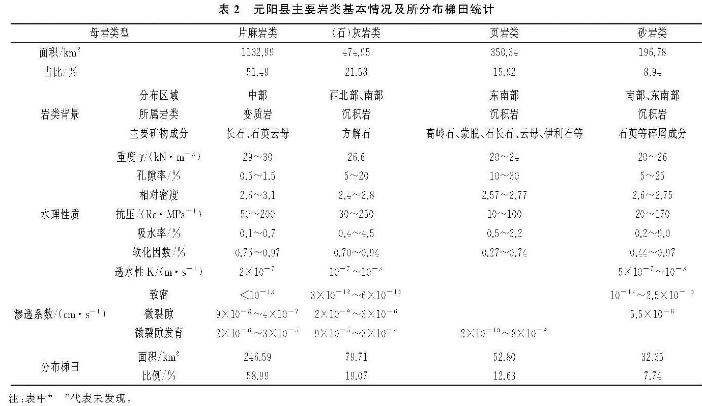
不同基岩水理性质不尽相同,所发育的土壤也不一样。片麻岩是中部主要岩类,面积达1 132.998 km2,占岩石面积的51.49%; 以片麻岩类为母质,发育土壤为单一的红壤(麻黄红土)、赤红壤(麻黄赤红土)。其他地区主要以灰岩类(474.95 km2,占总面积21.58%)、砂(砾)岩类(196.78 km2,占8.94%)以及页岩类(350.34 km2,占15.92%)等为主,土壤多为水稻土、沼泽土以及棕燥土等。从附图6可以看出,大面积的片麻岩类是中部梯田区特殊的岩石背景。其他岩石分布地区梯田面积较小,零星分布规模不大。
不同基岩水理性质,对水体保蓄能力不尽相同。片麻岩类岩石分布了246.59 km2梯田,占总面积的58.99%,是元阳县最主要岩类,也是中部梯田区特殊岩石背景。在湿热的山地立体气候环境下片麻母岩风化强烈,所含长石、云母等风化成细小颗粒物。同时,片麻岩山区是土层和风化层深厚,蓄水、保水性能好,土壤肥力高,土石方工程实施难度小,易于开发的区域[15],经过长期的人为耕作影响,上部不断熟化最终变成深厚耕作土体,颗粒细腻、粘度高、可塑性强,保蓄水能力大大提高。同时,底部基岩因上覆深厚土层、缺乏植物根系足够干扰而保持良好完整性,基岩裂隙不甚发育,相对密度大、透水性差(表2),基岩隔水性能良好。因此,中部梯田区得益于片麻岩底部隔水性和上部容水性为梯田水体起到良好的补给、调蓄作用,梯田景观的完整性从水源上得到保障。
南部、东南部、西南部的(石)灰岩类共474.95 km2,占总面积的21.58%; 分布了19.07%共79.71 km2的梯田。(石)灰岩属碳酸盐类岩石,具有很强的可溶性和渗透性; 加之区域气候湿润植被茂密,土壤和流水中有机酸的含量较高,水溶蚀作用明显,底部基岩不断受到侵蚀; 山高谷深的地形又导致水具有很强的流动性,在气候、岩性等因素综合作用下该地区的喀斯特作用强烈,岩石渗透系数大(表2),降水和地表径流以“喀斯特水”渗漏到地下深处无法有效利用,自然也就难以满足梯田所需的灌溉水源。
东南部和西南部的页岩类、砂岩类岩石,面积分别为350.34,196.78 km2,占比15.92%,8.94%,分布的梯田面积为52.80,32.35 km2,占12.63%,7.74%。与中部梯田区的片麻岩相比,砂页岩类孔隙度明显偏大,相对密度偏小(表2),渗透系数高,透水性强(表2),导致水体下渗严重不能很好保留,无法为梯田提供稳定、充足的灌溉水源。此外,砂岩和页岩的软化因数明显小于其他岩类(表2),软化因数值愈小,表示岩石在水的作用下的强度和稳定性愈差[16],这从岩性的角度说明砂岩和页岩所发育的土体缺乏足够稳定性,易于发生垮塌、滑坡等地质灾害; 尤其是砂砾岩,土体粒径大、砂性强,团聚体缺乏粘性而下渗量巨大,在利用上被用作梯田外的其他方向。
页岩类、(砾)砂岩类岩石受较高海拔的影响而抗冻性较差,尤其在冬春交替之际温度变化剧烈,岩石反复冻融基岩裂隙不断加大,原本不多的水体进一步加大了下渗量; 尤其是石灰岩类分布区,下渗更为明显。此外,这类岩石因含石英等较难风化颗粒物,风化产物大多质地偏砂、土体孔隙直径过大、团聚体结构疏松透水性能良好; 同时粘性结构弱,对水体的保持能力较差。尤其是砂岩分布区,土体良好通透性利于根系生长发育的同时,也会导致的严重透水,这对水稻生长是不利的。
2.4 梯田的土壤分异
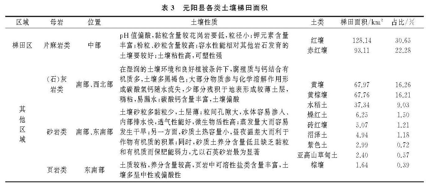
土壤性状受母岩性质影响极大,同时不同海拔分区也存在分异明显的土壤垂直带谱。中部梯田区主要受片麻岩类母质和亚热带海拔区间影响,发育为单一的红壤(麻黄红土)、赤红壤(麻黄赤红土),空间上集中连续分布(附图7)。
中部梯田集中区的麻黄红土、麻黄赤红土,土类上属红壤、赤红壤,两个土属面积为316.93,421.18 km2,分别占元阳县土壤面积的14.41%,19.16%; 所分布梯田面积为57.4,76.55 km2,占总面积的18.31%,13.73%。麻黄红土属砂质黏壤土,颗粒细小、基盐物质含量高(表3); 黏粒对钾、钙等离子养分有较强的吸附能力,降雨或灌溉时营养元素不至受淋洗而流失。本区另一种麻黄赤红土,土层深结构好,除速效磷较低外其他各种养分含量属中上,质地细腻,多粉砂质黏壤土。
从研究区范围看,红壤和赤红壤分布了221.25 km2的梯田,占52.93%(表3),两类土壤具有土层厚、黏土含量高的特性。黏土不仅阳离子养分多,而且腐殖质也较多,常常和黏粒紧密结合,增强了土壤的稳定性,进一步增强了养分的保持,是梯田可持续开发利用的重要保障。此外,黏粒粒间孔隙很小,互相联通成为曲折的毛细管而保水力强,水分进入土壤时渗漏很慢,但土壤中水分也不易蒸发,地下水能沿着毛管缓慢上升,在地下水位高时能增加土壤水分供应,抗旱力较强[17]。在长时间的生产实践中,哈尼先民逐渐探索出“三季节(冷季、暖季、雨季,每季4个月)”的劳作节律,每年除收获时短暂排水外其余大部分时间梯田都处于浸泡状态,这利于土壤中钾元素充分水解生成可溶性钾盐为作物吸收利用,同时也使得土壤内有机物与无机物不断进行迁移转化与合成,原有理化性质不断发生分异,对持水性能产生深远影响。尤其是整个冷季的蓄水泡田,使得土粒越发细腻、粘度不断增强。此外,上部森林在带来补给径流水体的同时,由于梯田修成水平面,并有一高出水平面的田埂,地表径流及其携带的泥沙在梯田中被截留,并逐级沉淀,从而达成保持水土的效果[18]。经过哈尼人民千百年的辛勤耕作,土壤自然属性发生极大变化,逐步演化成现在保水性能良好、养分含量高的黏土梯田区。
其他地区主要发育黄壤(麻黄土、棕黄泥土)、(潴育)水稻土、红壤(棕黄红土、黄红泥)以及燥红土等土壤,梯田空间上呈斑状分布面积规模不大。南部和东南部分布较多的是为黄红泥、棕黄红土、棕黄泥土,所发育的梯田面积较小(表3)。从性状上看,黄红泥土体含石英砂粒较多,多为砂质壤土或砂质黏壤土,土壤结持力较差[19]; 棕黄红土土体厚薄不一,层次分异较明显,因地处坡地水土流失较重而熟化度低。另一类棕黄泥土质地层次“下重上轻”,因缺乏有效锌、硼、铝等微量元素而供肥能力弱; 受区域地形影响灌溉条件困难,雨季未到易发生季节性干旱缺水,雨季则容易发生垮塌、滑坡等自然灾害。本区还存在一定量砂质土壤,一方面颗粒大而比表面积小,毛管水上升高度很低,水的作用难以得到充分发挥; 另一方面砂质土热容量比较小,土温昼夜温差大利于有机质积累的同时也极易引发冻害,这对水稻是一个潜在的威胁。西部、西南部和西北部土壤以麻黄土、潴育水稻土以及棕燥红土为主。麻黄土多处于坡地,土体薄、养分含量低且保水保肥力较差; 因受区域洼地地形影响,潴育水稻土亚氟化铁含量高,水面表层明显铁锈斑纹,阻挡水下气体交换,易产生硫化氢(H2 S)毒害植物根系,当地较少用于水稻种植。棕燥红土质地多为粉砂质黏土至黏土,有“晴天一把刀,下雨一包糟”的特点,耕性不良,当地多以旱地利用为主。西北部干热河谷地区降水少而蒸发大,同时干热气候会使土壤团聚体稳定性变异系数扩大; 不稳定的团聚体因形成可迁移的细小颗粒,阻断土壤水、肥、气的传输,同时加剧土壤侵蚀程度[20],加之受地形坡度影响,因此尽管位于河谷沿岸,但却没有发育为梯田。
因此,除中部以外其地区,也就没有发育大规模的梯田分布。