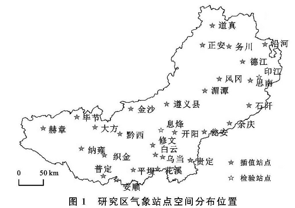
3.1 地形对气温分布的影响
乌江流域离海洋(太平洋、印度洋)较远,气温分布除经纬度影响外,地形成为重要因素,很多研究[20-21]已经涉及地形对温度影响。流域高差大,地形对气温影响不可忽视,该影响主要体现在海拔高度变化。总体看,流域气温从上游(赫章—水城)到下游(道真—沿河)逐渐升高。流域气温变化与海拔变化大致相反(图5)。流域低气温区主要分布在大于1 500 m的上游,主要包括毕节、赫章、纳雍、大方等。流域低气温区还有开阳周边,该分布与局部环境有关。流域中部海拔主要在800~1 500 m,气温低于赫章等地。较低气温区面积大,占流域面积1/3左右。流域中气温区呈北宽南窄,该特点可能与北部山地有关。中气温区南部海拔在500~1 000 m,北部部分山地1 000~1 500 m。较高气温区主要在流域中下游道真、正安、务川、余庆等地,呈南北向带状分布。相对南部,较高气温区北部宽,可能原因如下:(1)道真、正安、务川等属于小范围谷地,河谷盆地具有保温作用;(2)区域海拔降低,气温升高。气温高值区主要在流域东北部靠近重庆市附近,海拔较低,属乌江下游。综合看流域气温分布,自西南(上游)至东北(下游)逐渐升高,变化趋势与海拔相反,该变化与河流流向基本一致。
3.2 地形对降水分布的影响
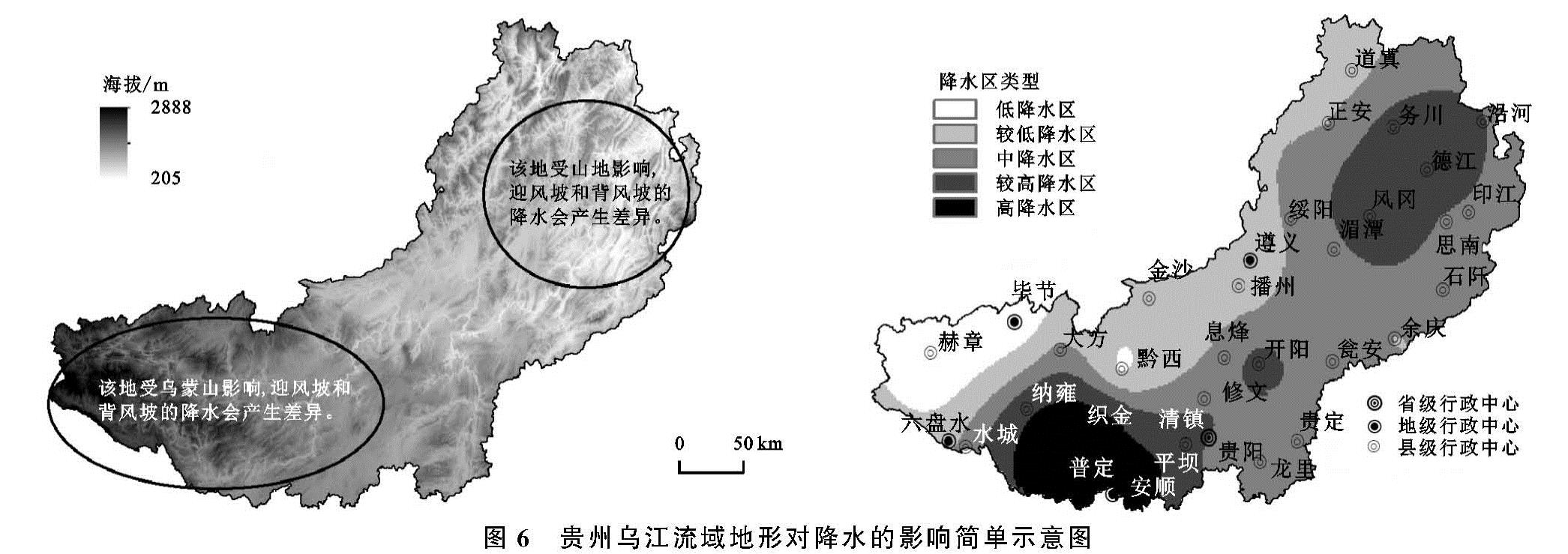
降水分布受地形影响,特别是山地迎背风坡及特殊地形对降水影响已有较多研究[22-23]。流域海拔变化复杂,迎背风坡变化较多,对降水产生显著影响。总体看,流域降水变化呈东南(南)向西北递减,西南部则由南向北递减明显(图6)。从贵定—毕节(赫章)、安顺—赫章降水总体逐渐减少且速度快,变化快与山地迎风坡有关。降水受地形阻挡,产生地形雨,地形雨形成变化较快降雨带。流域低降水区主要分布在上游北岸毕节—赫章。毕节—赫章降水相对较少,有以下原因:(1)海拔较高。(2)处于山地背风坡。(3)缺少湿润气流。毕节—赫章向东和东南,降水带呈东西向狭长分布,该特征与谷地地形、山地海拔、夏季风有关。黔西—纳雍一带属谷地,谷地使气流沿谷底上行,也对降水产生一定影响。该地属南北山地(六盘水—织金东西向山地)背风坡,多因素叠加使流域上游降水呈东西向狭长分布。普定—安顺—织金一带降水多,该带属夏季风山地迎风坡,地形阻挡增加降水。由于流域大环境相对湿润,山地东西延伸,使高降水区面积较大。另一相对较高降水区位于凤冈—德江迎风坡,降水偏多。凤冈—德江较高降水区分布大,呈东北—西南向,该特征与迎风方向和面积有关,东北—西南向迎风坡长且迎风面大,使降水与山地走向密切相关。流域中降水区面积广大,主要分布于中部。该区海拔较均匀,地形平坦,故降水分布较均匀,呈现大规模平缓降雨变化区。黔西降水少于周边,可能与谷地入口有关。黔西属气流入口带,风速相对较快,降水受此地形影响,偏少于周边。黔西周边降水呈圆形分布,该变化可能与插值方法有关。
3.3 模型参数检验
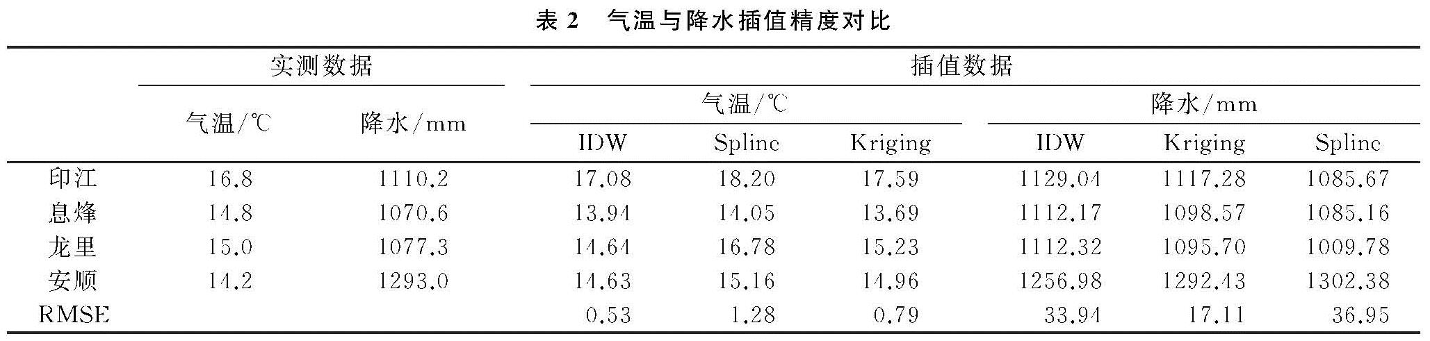
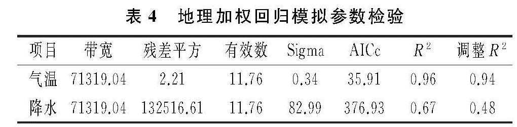
由于地形包括坡度、海拔、坡向等多种因子,坡度、坡向等虽对气温、降水具有影响,但其影响程度不如海拔明显。故本文仅模拟海拔对气温、降水的影响。气温模拟结果显示(表4),带宽为71 319.04,残差平方为2.21,有效数为11.76,拟合优度R2为0.96,调整R2为0.94。拟合效果好。利用GWR探究气温空间影响较为合适,其模拟系数具有良好参考。降水模拟结果显示,残差平方为132 516.61,带宽为71 319.04,有效数为11.76,拟合优度R2为0.67,调整R2为0.48。利用GWR探究海拔对降水影响整体尚可,空间模拟趋势具有一定的参考价值。
3.4 地形影响趋势空间特征
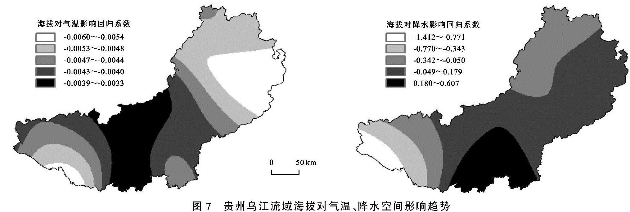
海拔对气温影响呈负相关系数,空间影响趋势并不一致(图7)。随海拔升高,气温处于下降趋势。流域海拔每上升1 000 m,气温空间下降范围3.3~6.0℃。海拔对气温影响程度下游、上游南部最明显。下游和上游南部海拔升高1 000 m,气温下降多在5℃以上。流域中部海拔对气温影响相对较低,且均匀和缓。中部海拔升高1 000 m,气温空间下降约为3.3~4.3℃。整体影响来看,海拔对气温影响程度中部低,下游和上游南部较高,空间影响程度具有异质性。出现以上变化特征,可能有以下原因:上游南岸山地为东西走向,1 800 m左右中高海拔区,海拔高气温越低,空间影响则越表现为明显。下游地形起伏大,多河谷,小尺度内气温变异明显,海拔对气温影响属于最明显区域。虽然下游影响明显,但下游变化趋势不如上游密集,这说明高大山地对降水影响程度和复杂性高于低矮山地。中游地势较为平坦,海拔影响也较为和缓,相对平坦地区对气温的影响程度和空间复杂性不如高海拔区和高起伏区明显,故空间影响趋势平缓且面积大。
海拔对降水影响正负均有,空间影响趋势并不一致(图7)。随海拔升高,降水在流域上游呈负向关系,可能是上游海拔相对较高,地形雨到一定阶段处于极限,降水不再持续增加,出现减少甚至焚风干燥效应,故表现为负影响。流域中游地形相对平坦,降水空间变化平缓,故中游地形对降水影响空间平缓分布。下游地形对降水影响呈东北—西南方向平缓变化,本文认为可能有以下原因:流域下游海拔相对较低,但地形起伏大,山脉为东北—西南方向,海拔对降水影响也呈东北—西南方向。此处地形虽起伏大,但多地区海拔不超过1 500 m,地形对降水影响有限。总体看,流域海拔每上升1 000 m,降水空间变化-1 412~607 mm,空间差异大。海拔对降水影响正负均有,流域上游影响主要为负向,流域中游大致为正向,但影响程度差异较大。定量探究海拔对降水影响需更多因素综合探究,GWR仅能反映基本趋势。