降水作为最重要的气象要素之一,是气象学、水文学、植被学和生态学等学科领域研究过程中的重要参数之一。而详尽的降水数据、特别是数字化的降水量是支撑多种生态系统模型和径流模拟最主要的设置参数,也是气候变化研究的重要指数,如何获得精度较高的栅格数据成为气候变化研究中的关键问题之一。随着地理学科的发展和GIS技术的进步,空间插值方法应运而生,空间内插就是基于某种数理方法采用已知的气象点数据来推求其未知的气象点数据,从而把矢量数据转换成栅格数据[1]。
常用的气象插值方法有克里金插值法(Kriging)、反距离加权法(Inverse Distance Weighting,IDW)和样条函数法(Spline)等。目前,国内外对气象要素插值方法的研究有很多,关于气温插值通常采用普通克里格方法[2-6],然而对于降水插值方法的使用一直处于选择阶段,没有一个确定的标准模型。
Daly等[7]对比加勒比海地区的年、月降水以及最高温和最低温插值的结果发现PRISM(Parameter-elevation Regressions on Independent Slopes Model,PRISM)模型的插值效果优于IDW方法。Marquínez等[8]基于多元回归方法和GIS技术手段对西班牙坎塔布连山区降水进行插值分析,结果表明多元回归法能够估计无气象站点地区的降水信息,并且指出地形对降水有主要的影响作用。石朋[9]、刘智勇[10]等都认为协同克里金方法的降水插值效果优于距离平方倒数法和普通克里金法。庄立伟等[11]在对东北逐日降水插值中认为IDW方法要优于克里格方法。王江[12]、谭剑波[13]、蔡福[14]等对比分析了基于Anusplin的薄盘样条法(Thin Plate Spline,TPS)与传统插值方法对降水数据进行插值比较,结果都一致认为TPS法对基本气象要素的插值误差最小。姜晓剑[15]、刘志红[16]、钱永兰[17]等针对基于薄盘样条法的Anusplin降水插值,分析了TPS的误差和应用。
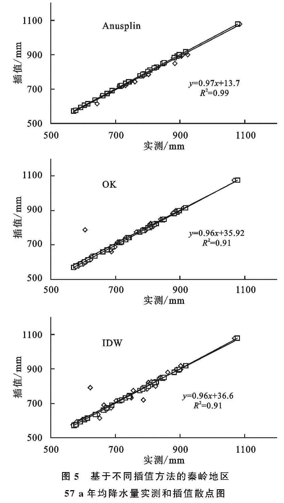
由于前人研究结果具有可靠性,但是不同的研究人员选取的研究方法不同,研究区域存在地形差异及数据时间尺度和空间尺度来源不一致,所得降水插值的精度误差也不同。就目前降水插值的研究方法来说,普通克里金方法很少考虑地形因素的影响; PRISM适宜于地形起伏较大的地方; 多元回归分析的优点在于估算的降水量不依赖于估算点周围区域气象站点的密集程度,可以直接根据地形参数求出降水量; 而基于Anusplin的薄盘样条法是一种采用平面平滑样条函数对多变量数据进行分析和插值的工具,它不仅考虑了地形对降雨量的影响,而且考虑了气象站点分布及数量对降水插值的影响,且有研究表明Anusplin对降水的插值结果优于其他几种插值方法[18-21]。
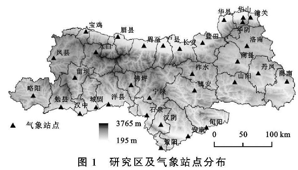
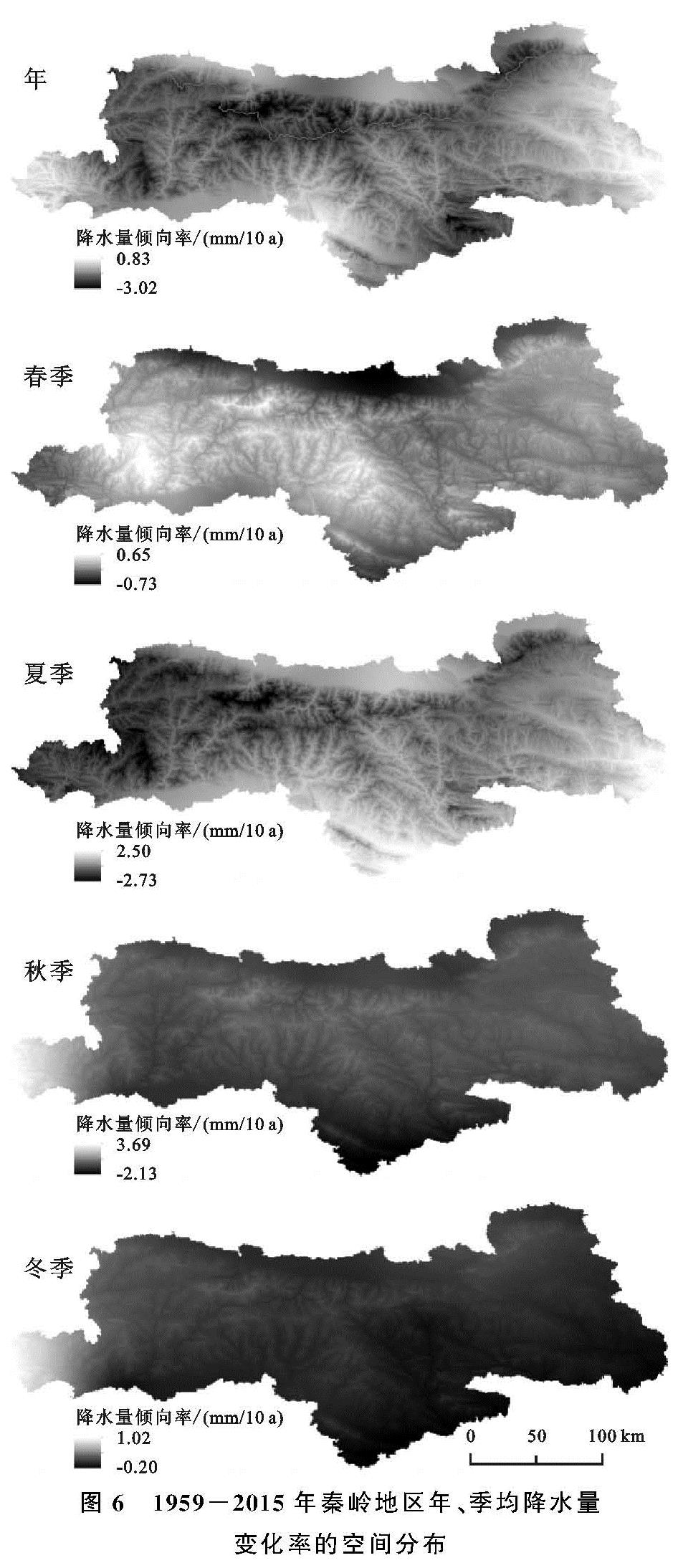
秦岭山地作为中国南北分界线,北仰南俯,相对高差大、最高海拔为3 771.2 m,由于长期缺乏高山气象站点,导致秦岭山地栅格降雨量数据难以获取。同时秦岭地区的降雨量对于全国的水热平衡、植被生长和农作物的产量等具有重要的影响作用。因此本文基于Anusplin软件以秦岭山地为研究对象,以DEM数据和31个气象站点1959—2015年的降水数据为基础,评估Anusplin插值方法在秦岭山地的适用性,阐明秦岭地区56年来降雨量的时空分布特征和变化趋势,旨在为探索全球变化和局地小气候的相关研究提供科学依据和理论支撑。