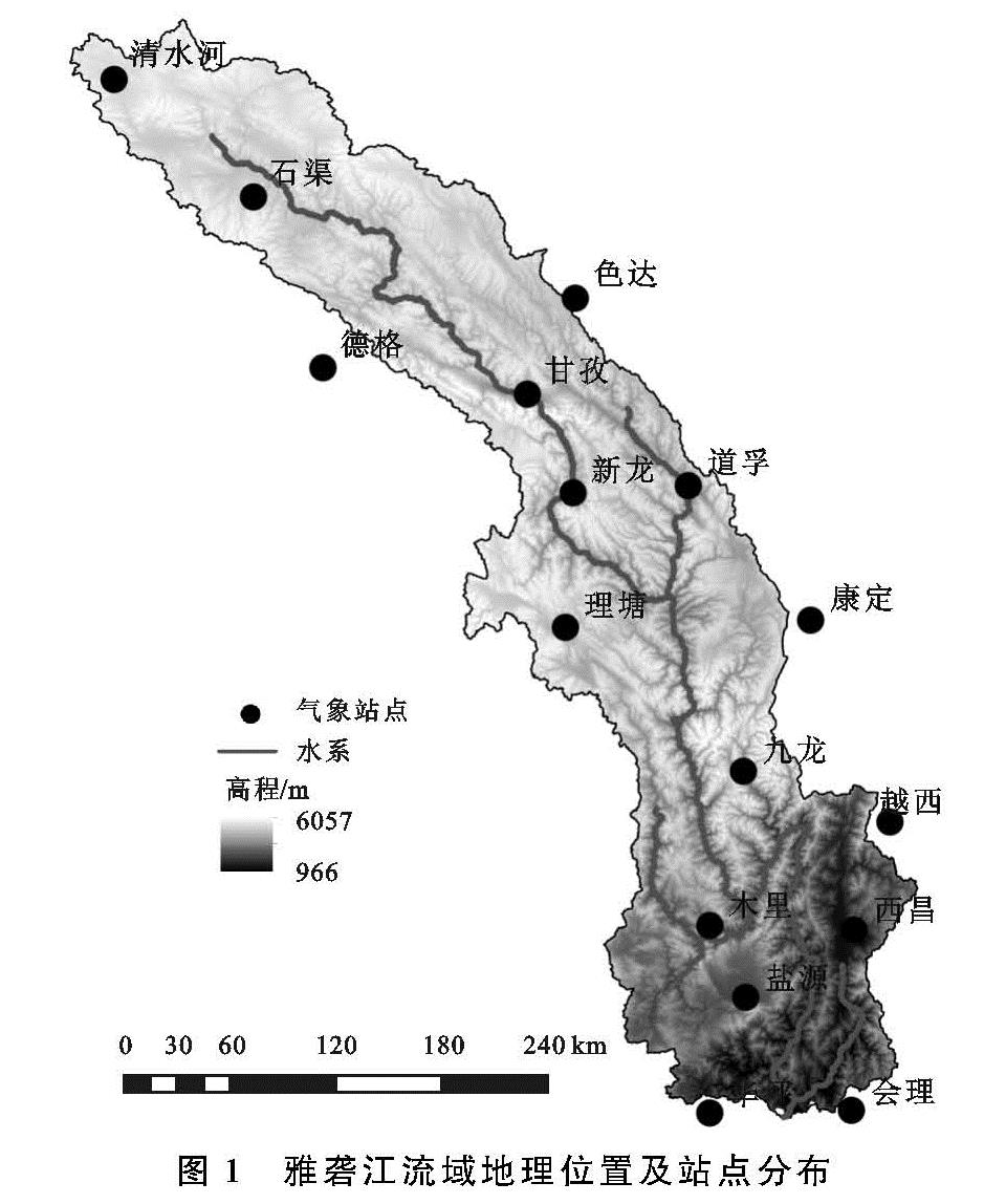
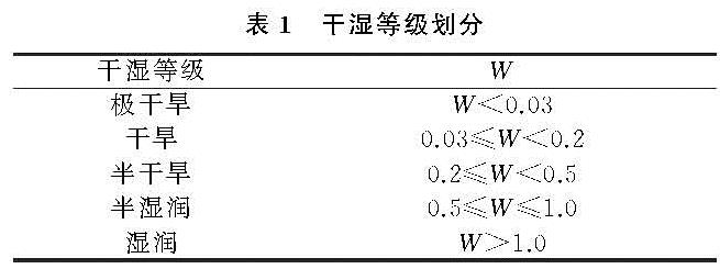
3.1 干湿指数年际变化特征
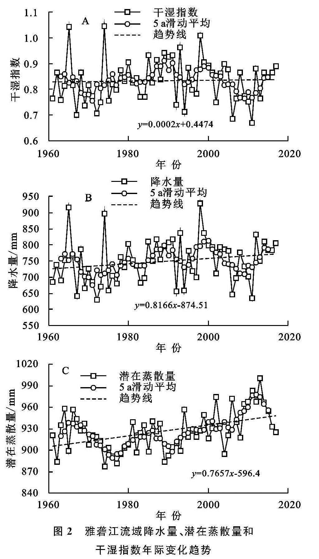
雅砻江流域1961—2017年降水量、潜在蒸散量和干湿指数的年际变化趋势如图2所示。从图2A可以看出,雅砻江流域年干湿指数整体缓慢上升,变化趋势为0.002 mm/10 a,年干湿指数最大值为1.04(1974年),最小值为0.67(2011年),多年平均干湿指数为0.88,年际波动幅度较大。从5 a滑动平均线可以看出,干湿指数在1961—1971年期间有所下降; 从1971—2009年,干湿指数呈双峰趋势,峰值分别出现在1989年、1999年; 在2009—2017年干湿指数呈上升趋势。
从图2B可以看出,雅砻江流域1961—2017年最大年降水量为929.0 mm(1998年),最小值为628.5 mm(1972年),多年平均降水量为793.2 mm,波动幅度较大,总体上呈现上升趋势,变化趋势为8.166 mm/10 a,其变化趋势与干湿指数基本一致。由图2C可知,流域年ET0最大值为1 000.8 mm(2013年),最小值为876.6 mm(1974年),多年平均ET0为924.6 mm,总体呈现上升趋势,变化趋势为7.657 mm/10 a,以1976年为界,1976年之前呈下降趋势,1976年之后呈波动上升趋势。
对比图2中降水量、潜在蒸散量和干湿指数的变化趋势,不难发现在1961—1971年、2009—2017年这两个时间段内三者的变化规律相似,分别呈整体减少和增加的趋势,这是因为在这两个时间段内降水量变化的斜率大于ET0,致使干湿指数呈减少和增加的趋势。而在1971—2009年内,降水量与干湿指数的变化趋势一致,而ET0的变化趋势不同,ET0在这段时间内总体呈波动上升趋势,而降水量同干湿指数一样呈双峰型变化趋势。降水量的第一个峰值出现在1989年,而在这个时间内ET0在总体上升过程中出现了一次回落,因此干湿指数在1989年出现了第一个峰值; 降水量的第2个峰值出现在1999年,而此时的ET0在总体上升趋势中趋于平缓,因此干湿指数在1999年出现了第2个峰值[18]。
图2 雅砻江流域降水量、潜在蒸散量和干湿指数年际变化趋势
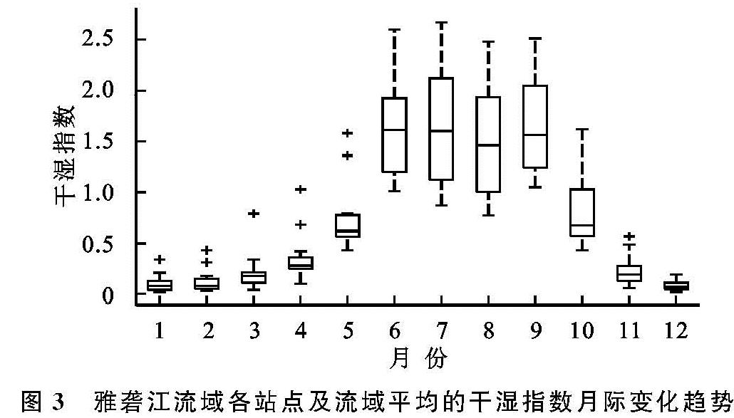
3.2 干湿指数月际变化特征
由于降水、气温、风速等因素在年内不均匀分布,因此不同月份的干湿指数存在差异[19]。雅砻江流域1961—2017年各站点及流域平均的干湿指数月变化趋势如图3所示。流域月平均干湿指数在年内整体呈单峰变化趋势,峰值出现在6—9月,最大值为1.60(出现在7月),最小值为0.08(出现在12月); 各站点的月干湿指数变化与流域总体变化一致,呈单峰型变化; 由此可见,雅砻江流域年内最湿润的时段为6—9月。流域在6—10月内每月各个站点之间的干湿指数差异较大,而在其他时间段各个站点之间的干湿指数则差异较小,产生这一现象主要是因为夏季流域大量降水和降水空间分布不均匀造成的。
图3 雅砻江流域各站点及流域平均的干湿指数月际变化趋势
3.3 干湿指数空间分布特征
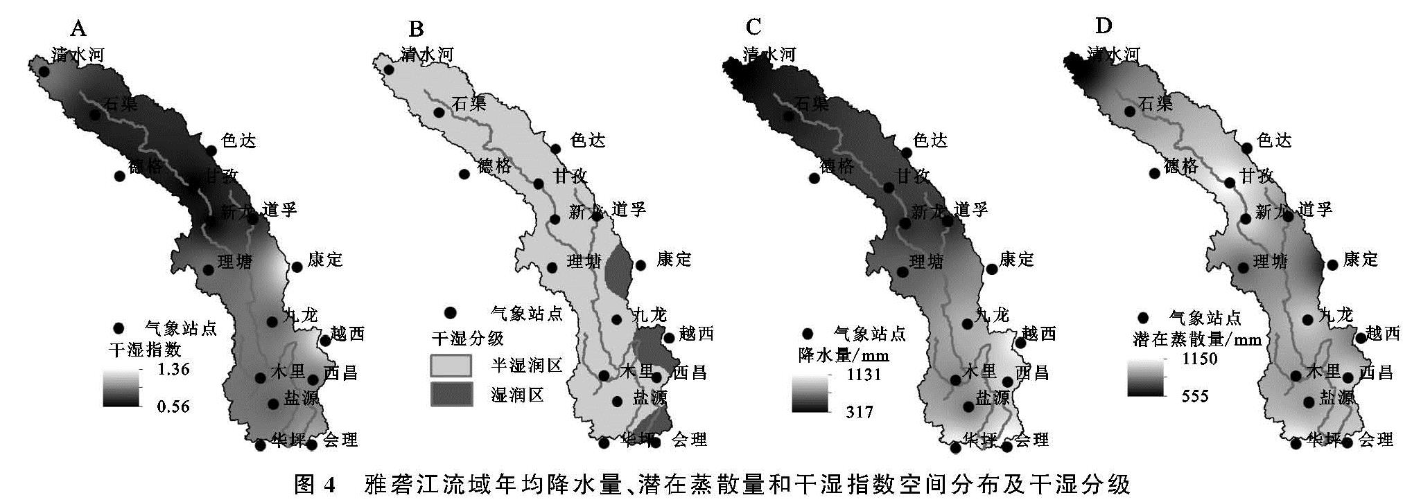
雅砻江流域1961—2017年年均降水量、潜在蒸散量和干湿指数的空间分布以及干湿分级如图4所示。从图4A中可以看出,流域干湿指数自下游向上游先减小后增加,整个流域的干湿指数在0.56~1.36范围内变化,根据中国干湿气候分区等级的划分标准,雅砻江流域属湿润和半湿润地区,半湿润地区占89.96%,湿润地区占10.04%(图4B)。干湿指数最大值为1.36,出现在流域下游的康定和越西站,最小值为0.56,出现在流域中游的甘孜和新龙站,整个流域除康定、越西和会理站外的其他区域均在半湿润区,气候偏干。
从图4C中可以看出,流域的降水自下游向上游逐渐减少,最大值为1 130.5 mm,出现在流域下游的会理站; 最小值为516.7 mm,出现在上游的清水河站,整个流域以理塘到康定一线为分界线,分界线以北年均降水在800 mm以下; 分界线以南年均降水在800 mm以上。从图4D中可以看出,流域潜在蒸散量自下游向上游先减小再增加再减小,最大值为1 149.9 mm,出现在中游的甘孜站; 最小值为555.4 mm,出现在上游的清水河站,整个流域除清水河、康定和理塘站外,其余区域的年均潜在蒸散量在750 mm以上。
对比图4C和图4D的分布图,以中游的新龙站为分界限,分界线以北降水量和潜在蒸散量都自新龙站向上游逐渐减小,但潜在蒸散量始终比降水量大,且它们之间的差值自新龙站向上游逐渐减小,所以干湿指数自新龙站向上游逐渐增大; 分界线以南降水量和潜在蒸散量都自新龙站向下游逐渐增加,但潜在蒸散量始终比降水量小,且它们之间的差值自新龙站向下游逐渐增大,所以干湿指数自新龙站向下游逐渐增大。
图4 雅砻江流域年均降水量、潜在蒸散量和干湿指数空间分布及干湿分级
3.4 干湿指数趋势分析
对雅砻江流域1961—2017年干湿指数序列进行Mann-Kendall趋势检验[20],结果见表2。
由表2可知,只有清水河、石渠和德格3个站点未通过95%置信度检验,表明3站的干湿变化并不显著。而其余13个站点中,有8个站点的倾斜度β大于0,表明干湿指数变化呈上升趋势,在倾斜度β小于0的5个站点中,越西、华坪和会理3个站的倾斜度较小,表明干湿指数呈缓慢下降趋势。将各站点的倾斜度β进行反距离权重空间插值,结果见图5。
从图5可以看出,流域69.41%的地区呈显著上升趋势,增加较明显的区域位于西昌和康定站,最大值为0.003 7; 最小值为-0.002 8,出现在下游的木里站。除西昌站外,雅砻江流域下游的干湿指数均呈下降趋势,表明气候趋于干旱; 除清水河、石渠站外,流域中上游的干湿指数呈上升趋势,表明气候趋于湿润。
综上可知,雅砻江流域的干湿指数整体呈上升趋势,整个流域总体趋于湿润化。
3.5 干湿指数突变分析
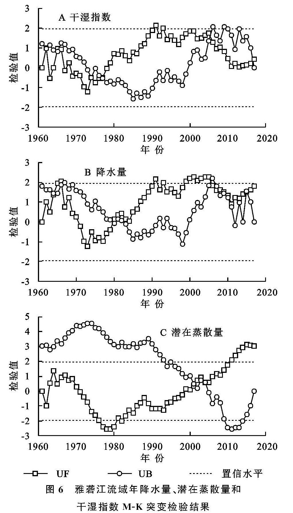
对雅砻江流域1961—2017年降水量、潜在蒸散量和干湿指数序列进行Mann-Kendall突变检验,结果见图6。由图6A可以看出雅砻江流域干湿指数存在两个突变点,突变年分别为1977年、2005年,两次突变均通过了95%置信度检验。在1977年前UF小于0,表明干湿指数呈下降趋势,而在1977—2005年UF大于0,表明干湿指数呈上升趋势,说明在1977年流域干湿指数发生了由低到高的突变。结合图6分析,流域降水量在1977年左右发生了由低到高的突变,流域潜在蒸散量UF值在1977年达到最小,由此说明1977年干湿指数发生突变主要是由降水量的增加导致。又由图6A可知,2005年后UF值迅速减小,说明在2005年流域干湿指数发生了由高到低的突变,结合图6C流域潜在蒸散量在2005年发生了由低到高的突变,说明了2005年干湿指数的突变主要是潜在蒸散量的增加引起的。
图6 雅砻江流域年降水量、潜在蒸散量和干湿指数M-K突变检验结果
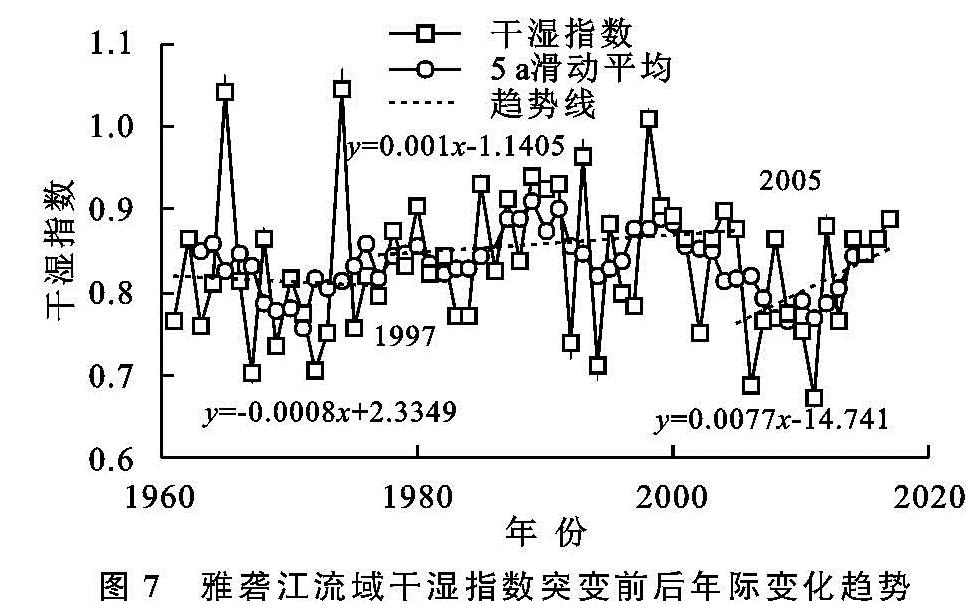
根据流域干湿指数的两个突变点可将1961—2017年干湿指数变化分为3个时期,各时期变化趋势如
图7所示。从
图7可以看出,在1977年前,干湿指数呈下降趋势,均值为0.81; 1977—2005年,干湿指数呈上升趋势,均值为0.86,流域干湿指数在1977年发生了由低到高的突变,突变量为0.05。而2005年后,干湿指数虽呈上升趋势,其均值为0.81,总体小于1977—2005年的均值,流域干湿指数在2005年发生了由高到低的突变,突变量为0.05。
3.6 干湿指数影响因素分析
由干湿指数的定义可知,其大小主要受降水量和潜在蒸散量的影响,而潜在蒸散量又与其他气象要素有关,如气温、风速、相对湿度和日照时间[21]。因此为了进一步探究气象要素对干湿状况的影响,对干湿指数与上述各气象要素进行相关分析,相关系数见表3。
从表3可以看出,干湿指数受到相对湿度的影响最大,相关系数为0.843(通过95%置信度检验),其次是降水量和潜在蒸散量,相关系数分别为0.682,-0.522(通过95%置信度检验),而干湿指数与气温、日照时数和风速的相关系数均未通过95%置信度检验,表明气温、日照时数和风速对干湿指数的影响相对较小。总体来看,干湿指数主要受相对湿度、降水量、潜在蒸散量影响,这些气象因子的共同作用同时影响着雅砻江流域气候干湿状况。