影响径流量变化的自然因素主要是气候变化,降水量和蒸散量变化是导致流域径流量变化的气候因子,随着径流量发生变化其输沙量也会发生相应的调整。近几十年来,人类活动对干旱、半干旱地区的流域径流量变化的影响逐渐加剧且往往成为主导因素[17-19]。下面,将从气候变化和人类活动两个方面来讨论它们对黄河下游输沙效率阶段性变化的影响程度。
3.1 气候变化的影响
根据黄河流域数百个气象站1950年以来的实测资料的统计分析结果表明,黄河流域蒸散量变化对流域内径流量变化的贡献率仅占4%左右[17],显然,蒸散量对于黄河流域径流量及输沙量变化的影响可以忽略不计,因此,蒸散量对于黄河下游输沙效率阶段性变化的影响也可忽略。
黄河流域百年尺度下气候的波动性变化导致降水量的变化主要是年际间的波动,而趋势性变化不明显。已有的研究结果表明,黄河源区和下游区年降水量无明显的长期变化趋势,中游在1988—2007年降水量平均值较多年平均值约下降10%,而黄河的径流量主要来源于兰州以上,表明降水量对黄河流域年径流量变化的影响不是主要控制因素[20]; 黄河流域年降水量变化率具有明显的空间差异性,总体表现为上游地区为正、中游为负的特点[21],这种不同地区降水量正负变化对流域径流量变化可以起到部分相互抵消的作用,可认为黄河流域的降水量变化对其下游年径流量变化的影响有限。还有研究结果表明,1950年以来,黄河流域径流量变化受到降水量和蒸散量变化的综合影响约占8%,而人类活动的影响高达92%左右[17],这也说明气候因素对黄河流域径流量变化影响甚微,而人类活动是黄河流域径流量变化的主控因素。
图5 黄河下游花园口-利津河段汛期排沙比年际和阶段性变化
表2 黄河下游花园口-利津河段汛期排沙比及其变化率
时期 河段排沙比 基变率/% 递变率/%1960—1965 1.341966—1981 0.78 -41.8 -41.81982—1987 1.01 17.2 29.51988—1999 0.62 -29.1 -38.62000—2015 1.48 64.2 138.7
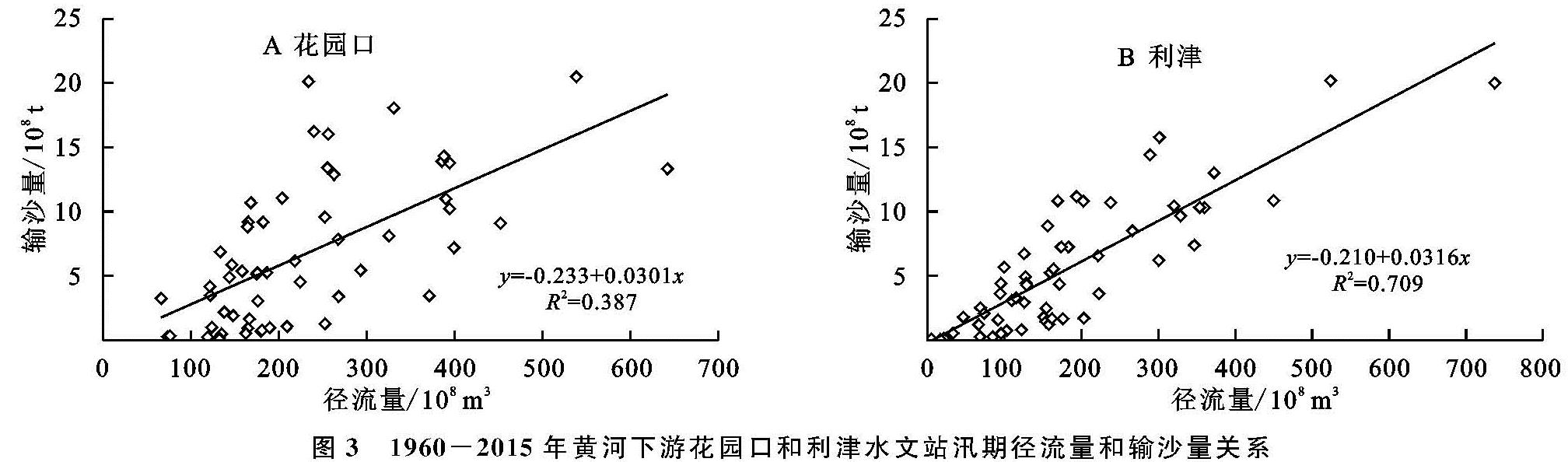
对于黄河下游汛期径流量变化来说,年际波动的汛期降水量对它会有一定的影响,但是对径流量时间尺度达年代际的阶段性变化来说,其影响同样有限。常军等[22]认为黄河流域夏季平均降水量为261.4 mm,在20世纪70年代偏多,90年代以来偏少; 秋季平均降水量为116 mm,在20世纪60年代显著偏多,90年代偏少,自21世纪00年代有增加趋势。因夏秋季基本是汛期,故黄河流域汛期降水量在20世纪60年代和70年代偏多而90年代偏小,对比黄河下游径流量年际变化(图1)可以发现,除了90年代降水量偏小与黄河下游径流量变小大致一致外,其他时期则并不相符。显然,黄河流域汛期降水量对其下游汛期径流量虽然有一定影响,但其影响程度仍然很小。汛期径流的输沙能力与径流量大小密切相关,黄河下游无论是上段的花园口站还是下段的利津站,汛期径流量与输沙量都具有明显的正相关关系(图3),因此,由黄河流域汛期降水量变化对其下游汛期径流量变化影响有限可以推知,汛期黄河流域降水量变化对其下游汛期输沙量变化的影响同样有限。
从上述讨论可知,气候因素对黄河下游汛期径流输沙效率和排沙比的阶段性变化的影响有限,因而,人类活动才是其主控因素。
3.2 人类活动的影响分析
3.2.1 水保措施的影响分析
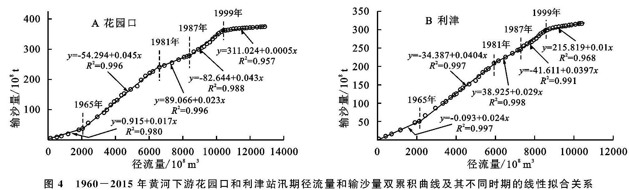
黄河流域自20世纪70年代以来实施的水保措施对于防治流域内水土流失卓有成效。这些水保措施主要有坡地地区的梯田建设和造林种草,沟道地区的淤地坝建设,以及2000年以来有效实施的坡地退耕还林措施,这些水保措施对拦水减沙影响有一定的差别。大规模的梯田建设有效减少了其分布区域的产流产沙能力,从而降低了该区域的输水输沙量,这会有效减少黄河下游的来水来沙量; 造林种草以及退耕还林都是以增加坡面植被的方法增大了土壤水分的入渗能力、减小了地表汇流能力,相应地减少了坡面产输沙能力,同样也会减少黄河下游的来水来沙量; 沟道淤地坝工程则是对径流及其携带的泥沙进行直接拦截作用,当非暴雨发生时段淤地坝上游区域的来水量往往不足以充满淤地坝,这时淤地坝拦截了全部的水沙,导致输沙量同比例减小,而当暴雨发生时,淤地坝以上区域的来水量往往会超过淤地坝库容,则有相对较多的泥沙沉积在淤地坝中,这导致流出淤地坝的径流量相对输沙量较多一些,无论如何,淤地坝的拦水拦沙作用也会明显引起其下游水沙量减少,众多淤地坝的综合拦水拦沙作用也会明显减少黄河下游的来水来沙量。上述各类水保措施所覆盖的区域基本上都是逐渐增加的,因此,其减水减沙量也有增强的趋势。因此,总体上来说,各种水土保持措施是引起黄河下游径流量和输沙量显著减小(图1)的主要原因,它们对流域内径流量和输沙量的减少基本上具有同比例特性,因而不会明显引起黄河下游输沙效率及排沙比的阶段性变化。但是,唯一例外的是,在20世纪90年代黄河中上游地区的淤地坝由于管理不善而出现了部分毁损现象,淤地坝的毁损会导致其拦截水沙量减少,而更为关键的是部分淤地坝内早年拦截的泥沙会在淤地坝毁损中被洪水侵蚀而向下游输送,这是黄河下游1987—1999年花园口和利津站输沙效率都较前一时段(1981—1987年)显著增大的主要原因。相应地,这些增加的泥沙由于在中下游河道缺乏有效的大坝拦沙库容(三门峡水库泥沙冲淤平衡无拦沙功能,小浪底水库尚未建成运行)而直接输送到黄河下游,其中相当一部分泥沙沉积在下游河段,使得1987—1999年黄河下游的排沙比相对于前一时段明显变小。
此外,黄河中上游流域水土保持工作的持续推进对于汛期小浪底入库水沙有着一定的影响,但由于库区泥沙的自然淤积和汛期出库水沙的部分人为控制,使得汛期下游河道输水输沙和水沙关系也必然受到人类活动的强烈影响,造成2000—2015年黄河下游断面径流输沙效率很低而河段排沙比很高的新现象。显然,随着人类活动尤其是大型水库的相继建成对水沙的拦蓄及调节,极大程度上改变了黄河下游汛期原有的水沙运行规律,造成断面径流输沙效率和河段排沙比的阶段性变化。
3.2.2 水库建设及其运行的影响分析
黄河下游汛期输沙效率和排沙比的阶段性变化基本与黄河主河道上几个大型水库的建成时间节点相吻合,1960年建成的三门峡水库在初期蓄水拦沙、在1962—1973年滞洪排沙[7],使得1960—1965年黄河下游来沙量小于来水量,从而形成该时期河道断面输沙效率很低、下游河段排沙比很高的特征,使得黄河下游河道普遍发生冲刷。因为三门峡水库泥沙严重淤积致使库区及库上平原区河道发生严重泥沙灾害,为了减小泥沙灾害,在1964年改造三门峡大坝、1969年开挖8个导流底孔以利于泄流排沙、1973年起的蓄清排浑[7],加之1968年建成的刘家峡水库,这两个水库运行的综合调节引起黄河下游花园口、利津站汛期的水沙关系进入新的变化阶段(1966—1981年),这时的花园口来沙量多,黄河下游沙量过载,虽然河道断面输沙效率高,但是河段排沙比较低,使得河段发生淤积。
1986年建成的龙羊峡水库,在汛期拦蓄洪水以减少黄河中下游的径流量,从而实现有效防洪的目的,加上三门峡水库在1990年又打开4个底孔排沙,使得汛期黄河下游水沙关系进入断面输沙效率高而河段排沙比很低的另一变化阶段(1988—1999年)。1997年实现截流、2001年竣工的小浪底水库,控制了92.3%的黄河流域面积、约90%的径流量和近100%的来沙量[10,23],汛期拦蓄洪水以及冲沙运行使得黄河下游水沙关系又有新的变化,从此,黄河中上游流域的来水来沙都经由小浪底水库的拦截和调节,黄河下游汛期输沙量和输沙效率则严重依赖于该水库的运行方式。小浪底水库在2002—2016年进行了19次调水调沙,使黄河下游主河道全线平均刷深1.85 m,平滩流量从1 800 m3/s增至4 310 m3/s[10,23],改变了水库运行之前黄河下游河道淤积萎缩的严峻态势。