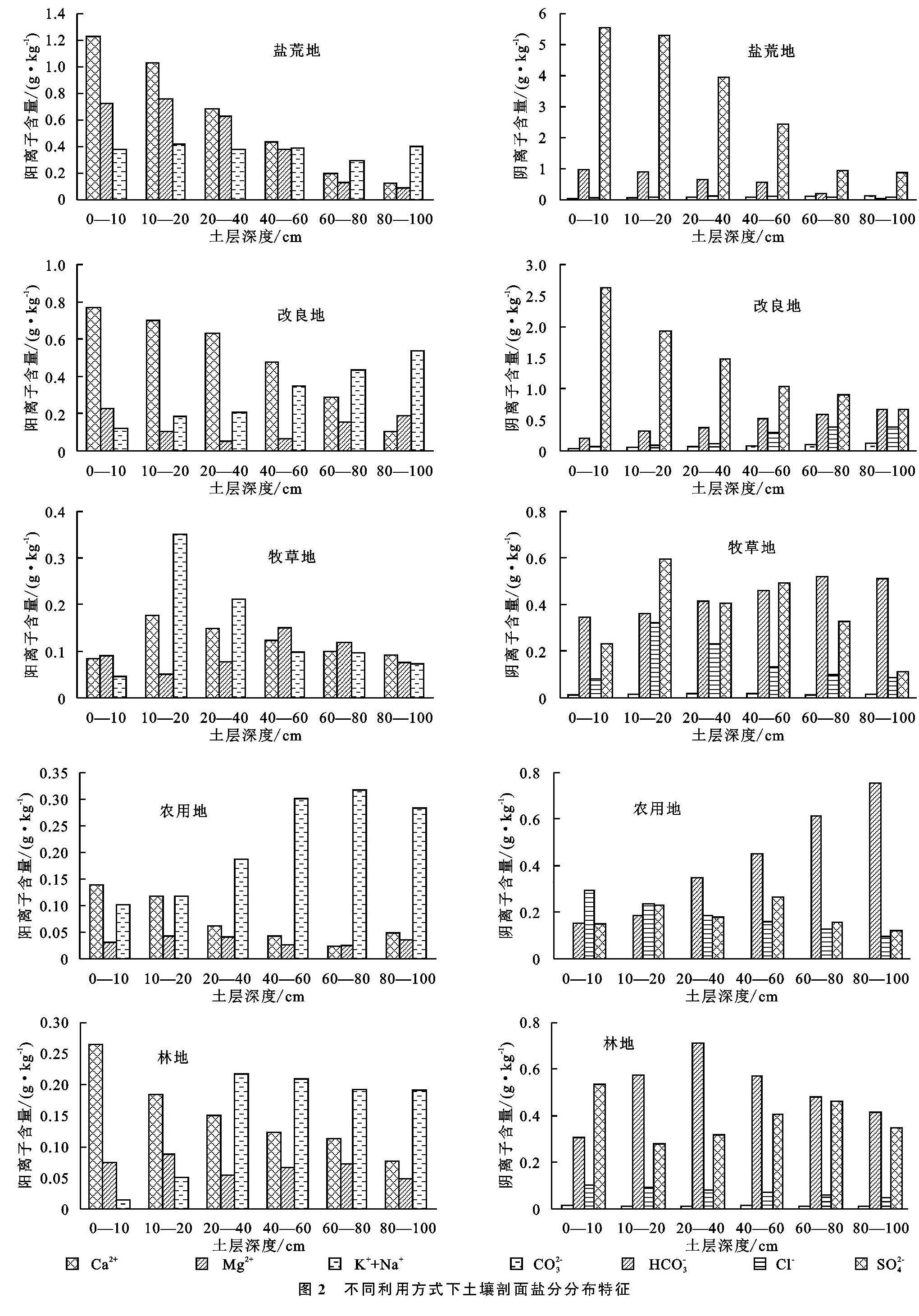
不同利用方式河套平原盐碱土盐分特征

(1.内蒙古农业大学 草原与资源环境学院, 呼和浩特 010011; 2.内蒙古自治区农牧业科学院资源环境与检测技术研究所, 呼和浩特 010031; 3.内蒙古自治区土壤肥料与节水农业工作站, 呼和浩特 010011; 4.榆林市榆阳区巴拉素区域农业技术推广站, 陕西 榆林719000)

盐碱土; 土壤盐分特征; 不同利用方式; 河套平原

Salt Characteristics of Saline-Alkali Soil in Hetao Plain with Different Utilization Methods
JING Yupeng1,2, LI Yuejin1, GAO Wa1,3, LIN Yali4 LI Xiuping2, WANG Wenxi2, ZHANG Xinxin2, DI Caixia2

(1.College of Grassland, Resources and Enviroment, Inner Mongolia Agricultural Unversity, Hohhot 010018,China; 2.Institute of Resources Environment and Detection Technology, Inner Mongolia Academy of Agriculture and Animal Husbandry Sciences, Hohhot 010031, China; 3.Inner Mongolia Soil and Fertilizer Work Station, Hohhot 010011, China; 4.Balasu Region Agricultural Technical Extension Station in Yuyang District, Yulin, Shaanxi 719000, China)

saline-alkali soil; soil salt characteristics; different utilization patterns; Hetao Plain

备注

为探讨土地利用方式对盐渍化土壤盐分特征影响,以河套平原5种利用方式(盐碱荒、改良地、牧草地、农用地、林地)下土壤为研究对象,采用野外取样与室内分析测试相结合的方法对其土壤剖面全盐量、盐分剖面类型以及盐分离子组成的变化规律进行了研究,结果表明:研究区土壤盐分离子以SO2-4,HCO-3,Ca2+,K++Na+为主; 剖面盐分离子分布不均匀,具有中、强变异性; 总体表现为:SO2-4>HCO-3>Ca2+>Na++K+>Mg2+>Cl->CO2-3; 土壤盐分变化与Ca2+,Mg2+,SO2-4变化规律基本一致,即随土层深度增加而减小。土地利用方式对土壤全盐含量及其离子组成的影响显著,盐荒地和改良地剖面土壤全盐量随土层深度增加而减少,农用地随土层深度增加而增大,牧草地随土层深度增加表现为先增加后减少,林地土壤全盐量剖面垂直变化幅度不大,且土壤剖面(0—100 cm)平均全盐含量依次为盐荒地>改良地>牧草地>林地>农用地; 人类活动使得土壤盐分含量下降了41.92%~79.33%,盐分类型由苏打氯化物型转化为苏打硫酸盐型,降低了盐碱的危害,且不同利用方式土壤全盐量与SO2-4,CO2-3,HCO-3,Ca2+,Mg2+,K++Na+均呈显著的正相关,而与Cl-成反比。本研究的结论对于提高盐渍化土地的利用潜力即耕地后备资源极其利用具有重要的理论和实际意义。

In order to explore the effect of land use patterns on salt characteristics of saline-alkali soil, the soils under five utilization modes(saline-alkali wasteland, improved land, pastoral grassland, agricultural land and forest land)in Hetao Plain were taken as the research samples. The variation of total salt content, salt profile type and salt ion composition in soil profile was studied by means of field sampling and indoor analysis. The results showed that SO2-4, HCO-3, Ca2+, K++Na+ were the main salt ions in the soils in the study area, the distribution of salt ions in the soil profile was uneven with moderate and strong variability, and the contents of the ions decreased in the order: SO2-4>HCO-3>Ca2+>Na++K+>Mg2+>Cl->CO2-3; Changes of soil salt contents were basically consistent with those of Ca2+, Mg2+ and SO2-4, the ion contents decreased with the increase of soil depth. The effects of land use patterns on soil total salt content and its ion composition were significant. Total contents of salts of wasteland and improved land decreased with the increase of soil depth, and Total contents of salts of agricultural land increased with the increase of soil depth. The soil total salt content of forest land increased at first and then decreased with the increase of soil depth, and the average total salt content of soil profile(0—100 cm)decreased in the order: saline-alkali wasteland>improved land>pastoral grassland>agricultural land>forest land, the salt content of soil were reduced by 41.92% to 79.33% due to human activities, and the salt type changed from soda chloride type to soda sulfate type, which reduced the harm of salt and alkali. The total salt contents of different utilization methods were positively correlated with SO2-4, CO2-3, HCO-3, Ca2+, Mg2+, K++ Na+, but inversely proportional to Cl-. The conclusions of this study can provide scientific basis for improving the utilization potential of salinized land and are of great theoretical and practical significance to provide scientific basis for the extreme utilization of cultivated land reserve resources.