3.1 土地利用变化分析
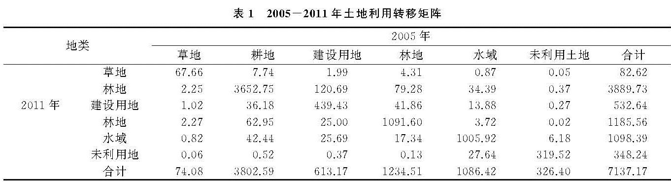
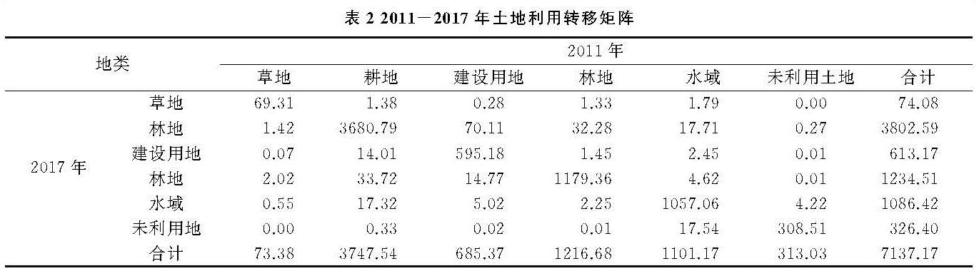
南昌市2005—2017年土地利用变化结果表明(表1,表2),林地主要分布于赣江西岸的湾里区,且东南方向随地形起伏呈带状分布。水域主要包括鄱阳湖、军山湖以及赣江等河流。耕地分布于地势较平坦的中部区域。建设用地扩张趋势明显。研究期内,土地利用数量和结构发生了显著变化,各土地利用类型间存在相互转化特征。2005—2011年,耕地面积减少了87.14 km2,其中林改耕地面积62.95 km2; 草地面积减少了8.53 km2,其中7.74 km2转化为耕地; 建设用地面积增加了80.53 km2,建设占用耕地120.69 km2,有36.18 km2建设用地复垦为耕地,这主要是因为部分农村居民点和矿山整治改良。水域和未利用地面积均有不同程度的减少,林地面积有所增长。2011—2017年,建设用地面积增加了72.20 km2,仍保持增长趋势; 林地是其他用地类型补充的主要来源; 水域面积由减少转为增加; 耕地、林地和未利用地面积仍是减少态势。
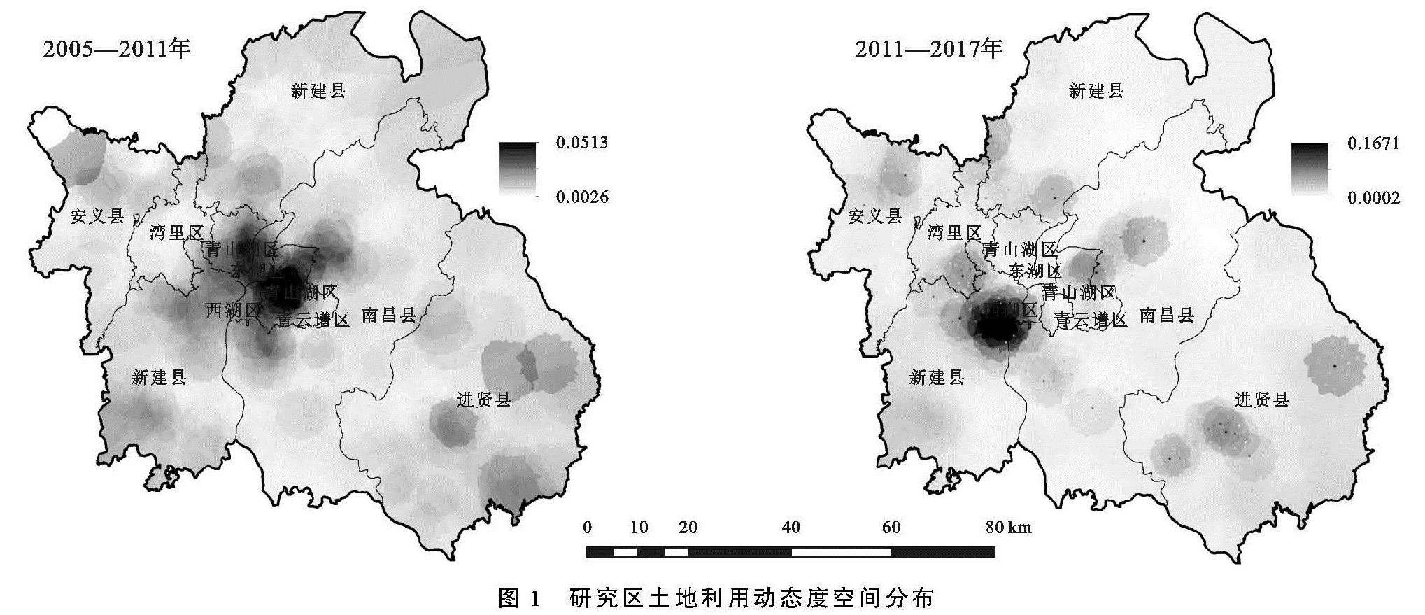
总体而言,2005—2017年生态用地呈现面积减少的趋势,尤其是草地和耕地。建设用地、林地和水域面积呈现增长态势,其中建设用地面积增长152.74 km2,增长率为28.68%; 林地面积增长31.13 km2,增长率为2.63%。草地、耕地与未利用地面积皆不同程度减少,其中耕地面积减少最大,为142.19 km2。动态度分析结果表明(图1),两时期内动态度高值区都位于南昌市中心城区,其他区域呈团状分布。与2005—2011年相比,2011—2017年动态度高值区从东湖区、西湖区向新建区转移,高值区域呈收缩态势。变异系数由2005—2011年的1.05增长至1.57,这说明不同区域的动态度分化差异更加明显,动态度空间差异性增大。
3.2 景观生态风险时空特征分析
3.2.1 变异函数分析
利用公式(1)—(3)计算得到每一个研究单元的生态风险值,然后赋值到中心点,最后基于GS+7.0软件平台进行变异函数拟合分析。经对数转换后,3个时期的生态风险值均与具有基台值的指数模型匹配度最佳,决定系数R2分别为0.987,0.998,0.912,模型拟合效果良好(表3)。块金值C0均大于0.3,且呈递减趋势,其中2011—2017年下降值更大。这说明,在某研究尺度范围内,生态风险具有内部变异性,且这种内部变异由随机性因素引起的可能性越来越低。2005年基台值最大,该时期南昌市的生态状况空间异质性最强,至2017年,基台值下降至0.604 2,说明生态风险空间分布均衡性有上升趋势,空间差异逐渐缩小。2005—2017年,块金效应值略微增长、变化不大,变程由117.6 km增大至288 km,随机性因素仍是南昌市土地利用生态风险指数空间变异的主导因素。
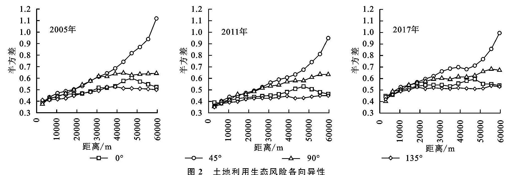
以顺时针45°为方向,对各个方向的空间变异性进行研究,结果见图2。可见,3个时期各方向的变异特征基本一致。45°方向上的变异程度最大,各方向的变异程度呈现45°>90°>0°>135°的趋势。以村为采样单元时,生态风险值具有中等水平的空间相关性,且空间自相关范围变大。土壤条件、地形差异等结构性因素与随机性因素(如尺度)引起生态风险空间变异比例相当[23]。随着社会经济的发展,土地利用、产业模式等人为活动构成的随机性因素对于生态风险空间变异的驱动力越来越大。
3.2.2 生态风险时空变化分析
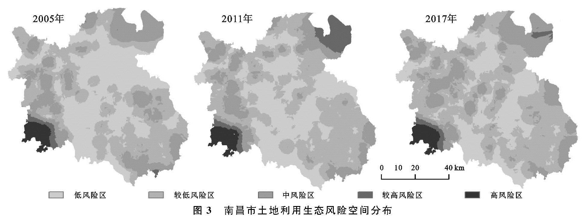
基于变异函数各参数的分析结果,在ArcGIS中利用普通克里格插值方法进行生态风险值插值(图3)。根据插值结果,按照自然断点法的原则将生态风险值分为5类[24]:低风险区(ERk<0.173)、较低风险区(0.173≤ERk<0.251)、中风险区(0.251≤ERk<0.415)、较高风险区(0.415≤ERk<0.675)和高风险区(ERk≥0.675),并统计各风险区的面积情况(表4)。
从图3可知,生态风险值呈现西南与东北两翼高、中间圈层式延伸的分布特点。2005年,南昌市辖区内处于低风险区和较低风险区的面积分别为2 631.08 km2,2 639.72 km2,共占研究区面积的73.85%,这部分区域主要以赣江为轴、向四周扩散。较高风险区和高风险区主要位于西南边陲,两个区域的总面积为291.52 km2,占比4.08%。2005—2011年,低风险区有向较低风险区转移的趋势,主要存在于毗邻鄱阳湖的昌北地区、赣江西岸,该区域是赣江新区昌九产业廊的核心发展地段,经济产业结构以农业向工业制造业转型,土地利用模式及效率发生了较大改变。同时,较高风险区的面积由98.38 km2增长至366.96 km2,变化的区域同样位于赣江新区的核心发展区。2011—2017年,中风险区的面积有较大变化,由1 158.07 km2增加至1 762.12 km2,增加了8.46%。由图3可知,这部分区域主要为南昌市中心城区,且在2011年中风险区的基础上向外蔓延。该时期内,南昌市城市的结构和功能区划发生了较大变化,城市形态从单中心、高集中向多中心、多群体的转变[25],城市建筑密度显著增加,自然景观的景观优势进一步降低。随着环鄱阳湖地区生态风险防范意识提高、生态产业体系转型升级,土地利用结构更加合理化,濒临鄱阳湖区域由较高风险区演变成中风险区,该区域土地利用生态风险状况得到好转。
总体而言,从2005—2017年,南昌市西南边陲始终处于高风险区域,未发生明显改变; 较高风险区面积起初出现大幅增长,后又回落基期年水平; 在中低风险区,生态风险值有逐渐增大趋势,低风险向较低风险或中风险恶化演替的趋势明显。
表4 南昌市土地利用生态风险各等级区域面积 km2
3.3 生态风险空间集聚特征分析
采用Geoda软件对南昌市土地利用生态风险空间自相关特征进行验证。南昌市2005年、2011年、2017年生态风险值的Moran's I值分别为0.451 9,0.424 3,0.401 0,呈波动下降趋势,结果与变异函数分析结果一致。这表明,研究期间南昌市土地利用生态风险结构和分布模式并不是随机无序的,而是具有一定的空间分布规律,即生态风险呈现空间正相关特性。具体而言,在一定距离阈值范围内,土地利用生态风险高的区域,其邻居对象生态风险值亦高,土地利用生态风险低值区域,其邻居对象生态风险值亦低。
由局部自相关分析得到LISA聚集结果(图4),3个时期的生态风险值均以HH型和LL型分布为主。其中,2005年HH型主要以组团状分布于南昌市中心城区、东北方向以及西南方向。这可能是因为中心城区经济活动较为集中,土地利用类型以建设用地为主,且中心城区的景观较为破碎,难以形成大面积集中式的生态景观,因而,这部分区域为高生态风险值。东北方向的HH区域毗邻永修县、濒临鄱阳湖,这可能是因为伴随着南昌市城市发展及经济建设、“昌九一体化”稳步推进,不得以“填湖造地”,导致具有高生态价值的水域和湿地被破坏,从而增加了该区域的生态风险。西南方向的HH区域主要是新建区石岗镇和松湖镇部分区域,此为高安市、丰城市和南昌市交界地带。石岗镇丘陵山地较多,土壤侵蚀速率较大,且水土流失严重。松湖镇地势平坦、交通便利,是重要的商品粮输出基地,土地利用趋于多样化,生态风险抗干扰性较弱。LL区域主要以带状分布于南昌县、新建县、进贤县边缘交错地带,该地带土地利用类型以林地或耕地为主,土地利用趋于稳定,景观类型受外界干扰程度较低。南昌县境内的LL区域主要为地势平坦且集中连片的耕地,景观连通性较好、抗干扰性强。LH和HL区域呈零星状分布,无明显分布规律。至2011年,HH聚集区略有收缩趋势,濒临鄱阳湖地区不再呈生态风险高值聚集区,这可能是得益于2009年鄱阳湖生态经济区纳入国家级战略发展区域,社会各界加强了对于生态保护的行为。LL聚集区收缩较为明显,但仍以带状型分布于行政区的边界处。至2017年,濒临鄱阳湖的东北区域呈现高值聚集特征,且与前两个时期相比,面积明显增大。经过十多年的发展,工业、制造业都发展较成熟,过于密集的产业发展可能使土地生态承载力处于满载或超载状态,这对于生态环境的保护是不利的。在西湖区和东湖区等中心城区,LL聚集区有向HL、HH聚集区转型的趋势,中心城区是人口较为集中的区域,城镇化水平较高,难以形成结构完整、功能齐全的景观类型,故而中心城区土地利用生态风险不容乐观。湾里区与安义县交界地带演化成为LL聚集区,该区域植被覆盖度高,人类活动对生态风险扰动影响较弱。