2.1 LRF的GCP测量精度
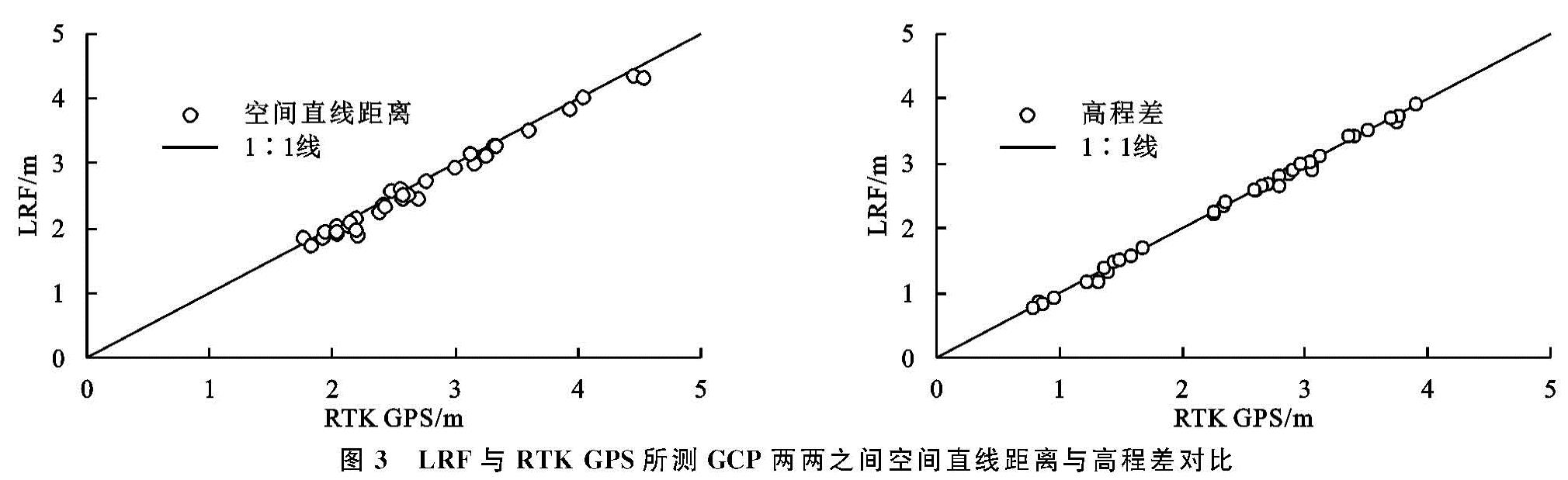
图3对比了LRF与RTK GPS所测GCP空间直线距离与高程差。结果表明,无论是空间直线距离还是高程差,LRF的测量结果与RTK GPS十分接近,对应散点均靠近1:1线分布。此外,两种方法得到的空间直线距离相关系数为0.993,高程差相关系数为0.999,均在0.01的置信水平显著。可见,LRF可有效测量GCP的空间分布与相对位置,为获取GCP坐标与重建切沟三维形态提供了另外一种可能方法。相比RTK GPS,LRF便宜、轻便,测量过程高效易行,可极大地减少SfM方法测量切沟时的设备费用,减轻野外作业负担。
2.2 SfM摄影测量法的切沟测量精度
2.2.1 RTK GPS、断面测量法、SfM摄影测量法所测切沟参数比较
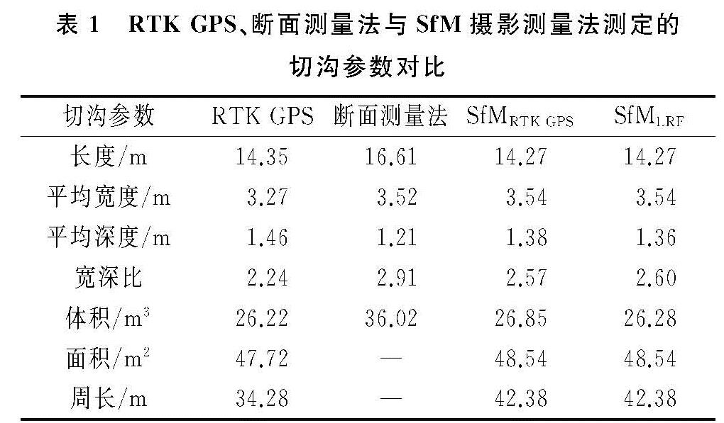
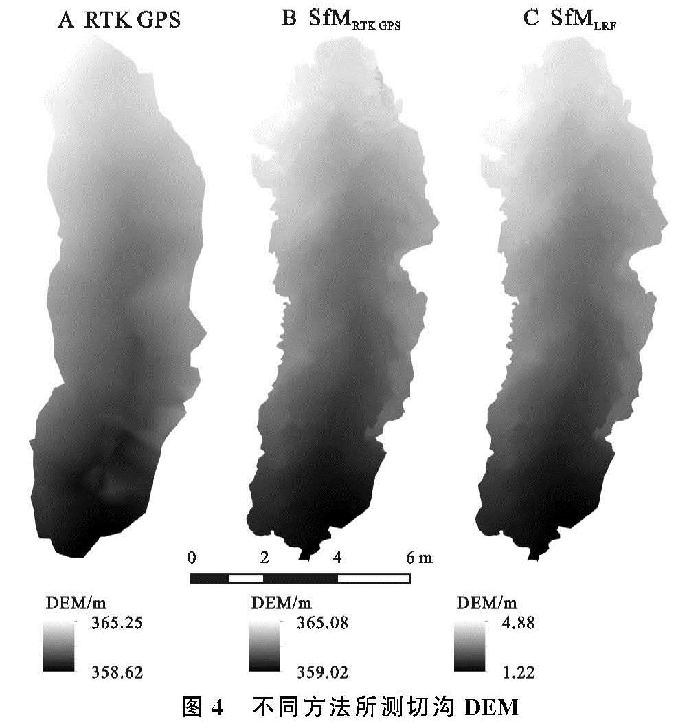
表1为RTK GPS、断面测量法与SfM摄影测量法测量得到的目标切沟主要形态参数。其中,RTK GPS通过其所测各点的坐标信息重建DEM(图4A)后提取切沟长度、平均宽度、平均深度、体积、面积与周长; 断面测量法主要测量切沟各段的横断面面积与其代表长度,用以估算切沟长度、平均宽度、平均深度与体积,并未测量切沟面积与周长; SfM摄影测量法分别利用RTK GPS所测的大地坐标(SfMRTK GPS)与LRF所测的独立空间直角坐标(SfMLRF)重建DEM(图4B,C),提取得到对应的两组结果。
除平均宽度外,断面测量法相比RTK GPS测得的各参数误差均较大。长度、体积分别高估了15.75%与37.28%,平均深度低估了17.12%。因为平均深度的影响,宽深比较RTK GPS高估了29.91%。这主要是因为断面测量法法概化了切沟形态,忽视了沟内细节,且切沟测量横断面的位置选取与卷尺读数受人为因素影响较大。相比于尹佳宜等[5]在东北黑土区切沟体积测量中得到的~10%的误差,本研究的断面测量法误差较大,这可能与选取切沟的规模有关。前者测量了3条切沟,体积均超过500 m3,在所用卷尺精度一致的情况下,总体积越大,误差百分比相应越小。
相比之下,SfM方法对切沟的测量精度高得多。由于SfMRTK GPS与SfMLRF均基于重建切沟DEM的坡度转折提取其沟缘线,所得沟缘线轮廓一致(图4B,C),对应的长度、平均宽度、周长与面积也相等。其中,长度相比RTK GPS仅低估了0.56%,平均宽度与面积分别高估了8.26%与1.72%。就体积而言,SfMRTK GPS得到的结果为26.85 m3,相对RTK GPS的误差为2.40%; SfMLRF的结果为26.28 m3,误差仅为0.23%。无论基于何种GCP坐标,SfM摄影测量法均表现出较高的切沟体积测量精度,极大地优于断面测量法(表1)。然而,SfM摄影测量法提取的切沟周长却远大于RTK GPS的结果,前者比后者长8.10 m,增幅达23.63%。这是由于RTK GPS得到的是密度较低的点数据,仅可体现沟缘的大致走向(图4A); 而SfM法基于重建的三维点云得到DEM,由此提取的坡度信息可使沟缘走向变得清晰,细节得以充分体现,经矢量化的沟缘线更加细致,周长更长(图4B,C)。
图3 LRF与RTK GPS所测GCP两两之间空间直线距离与高程差对比
表1 RTK GPS、断面测量法与SfM摄影测量法测定的切沟参数对比
2.2.2 SfM摄影测量法与RTK
GPS所测切沟DEM对比 虽然SfMRTK GPS与RTK GPS均基于大地坐标开展DEM的重建与计算,但SfMLRF采用独立空间直角坐标系,无法与RTK GPS所测切沟DEM进行直接比较。因此,将所测切沟DEM与对应沟缘面DEM作相减运算,获得切沟相对DEM后进行SfM方法与RTK GPS的比较。
图5为SfMRTK GPS,SfMLRF所得切沟相对DEM与RTK GPS所测结果的差值。显然,无论基于何种坐标系,SfM方法得到的切沟相对DEM比之RTK GPS结果总体呈西北高、东南低的态势。这可能是因为试验当天的切沟照片拍摄于上午,切沟西北岸光线充足,深处细节曝光充足,进行三维重建的三角测量计算时,相机与所摄地物的距离较实际距离偏小,高程偏大,与GPS结果相减呈正值。而切沟东南岸光线较暗,物体远近对比较不明显,相机与地物的距离较实际距离偏大,后期计算的高程偏低,与GPS结果相减呈负值。可见,摄影测量法的使用一定程度上受限于天气条件,需确保所测地物所有部分的光线条件基本一致[28]。
图5 (A)SfMRTK GPS、(B)SfMLRF与RTK GPS所测切沟相对DEM差值
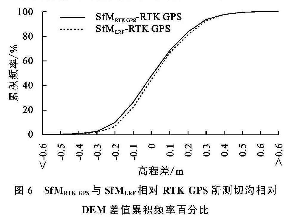
此外,基于两种方法得到的目标切沟相对DEM,对各栅格高程作配对t检验,结果显示,SfM
RTK GPS,SfM
LRF均与RTK GPS存在显著差异(p <0.01),但总体差异很小,前者与RTK GPS的平均高程差值仅为-0.02 m,后者与RTK GPS的平均高程差值略高,也仅为-0.04 m。进一步对比DEM各栅格的高程差值也发现,SfM
RTK GPS与RTK GPS所测切沟相对DEM高程差值均不超过1.00 m,且主要集中于-0.2~0.2 m范围内,对应栅格数量占比73.72%; SfM
LRF与RTK GPS的DEM相对差值不超过0.9 m,同样集中于-0.2~0.2 m范围内,对应占比74.58%(
图6)。这一结果说明SfM摄影测量法与RTK GPS所测切沟DEM总体差别不大,是一种高精度的切沟测量方法。同时,LRF也可有效替代RTK GPS应用于GCP的测量及后期切沟三维形态的重建。
2.3 不同GCP布设方案对SfM摄影测量法测量精度的影响
图7为不同沟缘与沟底GCP抽稀方案所得切沟DEM与基于所有18个GCPs(未抽稀)所得DEM的差值。由于LRF所测GCP两两之间的空间距离与高程差与RTK GPS结果无显著差异,且由此获得的切沟DEM与RTK GPS结果差别也不大,此处各方案所取GCP坐标为LRF测得的独立空间直角坐标。总体而言,不同程度的沟缘与沟底GCP抽稀对生成的切沟DEM影响不大。尽管GCP沟底不抽稀、沟缘均匀抽取1/2大范围地低估了切沟高程(图7D),GCP沟底全部缺失、沟缘均匀抽取1/3大面积高估了切沟高程(图7I),但其低估与高估程度均不超过0.15 m。
图6 SfMRTK GPS与SfMLRF相对RTK GPS所测切沟相对DEM差值累积频率百分比
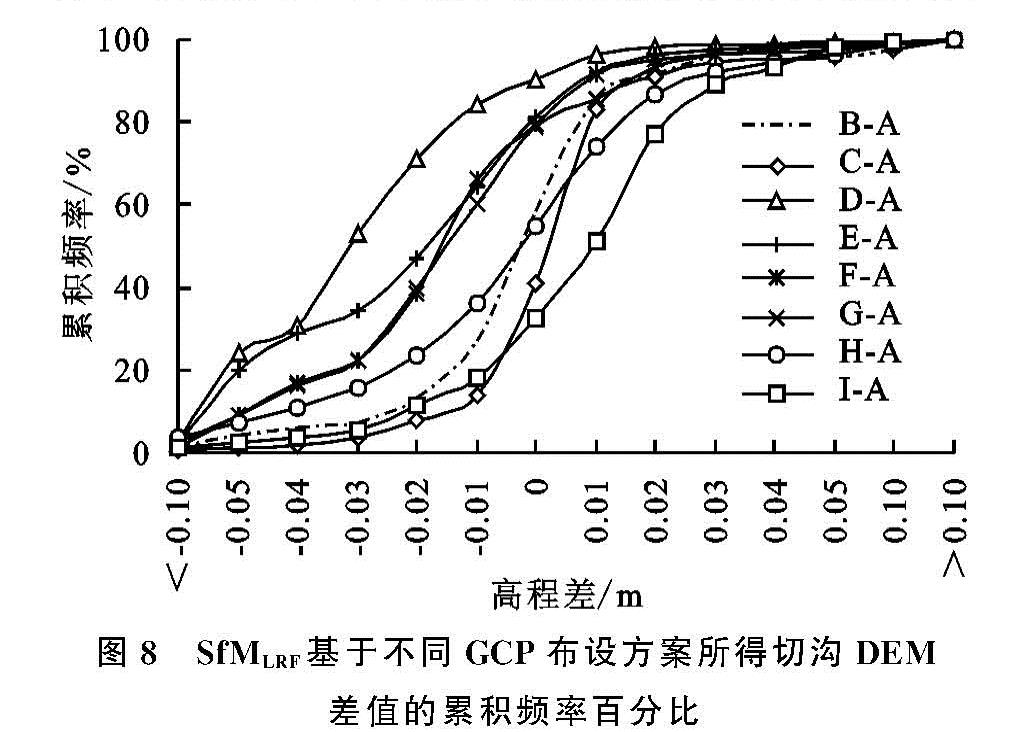
基于各抽稀方案与未抽稀方案得到的切沟DEM,对各栅格高程作配对t检验,结果显示,不同方式的GCP抽稀均显著改变了各栅格高程(p<0.01),但总体幅度不大。各抽稀方案与未抽稀情况的DEM栅格平均高程差值介于-0.03~0.01 m范围内。进一步统计DEM各栅格的高程差发现,各抽稀方案所得切沟DEM相比未抽稀结果的高程差值主要集中于-0.05~0.05 m范围内,对应栅格数量占比均超过70%(
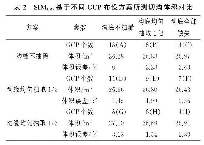
图8)。此外,各GCP抽稀方案得到的目标切沟体积介于26.43~27.10 m
3,相比未抽稀方案的误差介于0.56%~3.13%(
表2)。这一结果说明SfM摄影测量法基于不同GCP布设方案得到的切沟DEM总体误差较小,均不超过5%。因此,即使GCP数量低至4个,也可满足大多数情况下的切沟体积测量精度。
图7 SfMLRF基于不同GCP布设方案所得切沟DEM差值
图8 SfMLRF基于不同GCP布设方案所得切沟DEM差值的累积频率百分比
一般来说,GCP数量越多,所摄地物的三维形态越精确
[20,29]。并且,GCP是否均匀分布、是否在地势剧烈处进行加密,也会影响SfM方法的测量精度
[30]。但本研究中切沟DEM或体积精度并未随GCP数量,特别是沟底GCP数量明显变化。这可能与目标切沟沟底较浅、规模较小有关。一方面,目标切沟沟宽约3 m,长约15 m,少量的GCP便可满足精度需求; 另一方面,沟缘最高处与沟底最低处高程差不足7 m(
图4),在沟缘拍摄照片时也可将沟底拍摄在内,沟底的尺度信息可在后期的三维重建过程中通过提取照片中的其他地物特征信息获得,沟底有无GCP,GCP数量多少对切沟DEM重建影响较小。但当研究对象为如黄土高原地区广泛分布的体积、高差较大的切沟时,还需进一步探究GCP布设方法对切沟测量的影响。
表2 SfMLRF基于不同GCP布设方案所测切沟体积对比